- Ontario Highway 560
-
Highway 560
Route information Maintained by the Ministry of Transportation of Ontario Length: 193 km (120 mi) Major junctions East end:  Highway 11 in Englehart
West end:  Highway 144 / Sultan Industrial Road
Location Divisions: Sudbury District, Timiskaming District Villages: Shining Tree, Westree, Gowganda, Elk Lake, Mount MacDonald, Charlton, Englehart Highway system Ontario provincial highways
400-series • Former←  Hwy 559
Hwy 562  →
→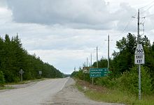 The western terminus of Highway 560 at Highway 144
Secondary Highway 560, commonly referred to as Highway 560, is a provincially maintained secondary highway in Northern Ontario. It begins in the west at Highway 144 and its eastern terminus is Highway 11 at Englehart. Having been re-aligned numerous times, the highway's current and former alignments follow each other very closely and are visible to each other for most of the length of the road, with third and fourth alignments in the nearby forests easily visible from the sky with photos from Google Earth between Highway 560A (a 10 km-long spur to Westree) and Elk Lake, for example.
Contents
Route description
The highway between Elk Lake and Highway 65 has been recently repaved, along with the new alignment being built. The old alignment of the road is still used in many areas, as a residential access to the highway.
Highway 560 is also the closest road in Ontario to the province's highest point, Ishpatina Ridge.
The road is linked to Highway 667 in Sultan via the Sultan Industrial Road, a private, gravel-surfaced logging road with public access.
There are few gas stations and services located along this route, as it travels through the most isolated parts of Northeastern Ontario. The highway is heavily travelled by logging trucks, and warning signs are posted along the route.
Highway 560A
Highway 560A is a secondary highway which serves as a short spur route from Highway 560 to the community of Westree. Its total length is approximately 10.4 kilometres (6.5 mi).
Major intersections
The following table lists the major junctions along Highway 560.[1][2]
Location km[1] Destinations Notes  Highway 560 continues west as the Sultan Industrial Road
Sudbury 0.0 Highway 144 – Sudbury, TimminsMorin Village 31.0 Highway 560A – Westree 41.7 Opikimimk River Bridge Timiskaming Gowganda 100.9 Gowganda Creek Bridge Elk Lake 143.3  Highway 65 west – Matachewan
Beginning of Highway 65 concurrency 144.3 Highway 65 east – New LiskeardEnd of Highway 65 concurrency Charlton 173.9  Highway 573 (Bay Street)
Englehart 183.1 Highway 11 – New Liskeard1.000 mi = 1.609 km; 1.000 km = 0.621 mi References
- ^ a b Ministry of Transportation of Ontario (2007). "Annual Average Daily Traffic (AADT) counts". http://www.raqsb.mto.gov.on.ca/techpubs/TrafficVolumes.nsf/tvweb?OpenForm&Seq=5. Retrieved September 2, 2011.
- ^ Peter Heiler (2010). Ontario Back Road Atlas (Map). Cartography by MapArt. p. 105, section J16–18. ISBN 978-1-55198-226-7.
External links
Secondary highways of Ontario Secondary Highways 502 · 510 · 516 · 518 · 519 · 520 · 522 · 522B · 523 · 524 · 525 · 526 · 527 · 528 · 528A · 529 · 529A · 531 · 532 · 533 · 534 · 535 · 537 · 538 · 539 · 539A · 540 · 540A · 540B · 542 · 542A · 546 · 547 · 548 · 550 · 551 · 552 · 553 · 554 · 556 · 557 · 558 · 559 · 560 · 560A · 562 · 563 · 564 · 565 · 566 · 567 · 568 · 569 · 570 · 571 · 572 · 573 · 574 · 575 · 577 · 579 · 580 · 581 · 582 · 583 · 584 · 585 · 586 · 587 · 588 · 589 · 590 · 591 · 592 · 593 · 594 · 595 · 596 · 597 · 599 · 600 · 601 · 602 · 603 · 604 · 605 · 607 · 607A · 608 · 609 · 611 · 612 · 613 · 614 · 615 · 617 · 618 · 619 · 621 · 622 · 623 · 624 · 625 · 626 · 627 · 628 · 630 · 631 · 632 · 633 · 634 · 636 · 637 · 638 · 639 · 640 · 641 · 642 · 643 · 644 · 645 · 646 · 647 · 650 · 651 · 652 · 654 · 655 · 656 · 657 · 658 · 661 · 663 · 664 · 665 · 667 · 668 · 670 · 671 · 672 · 673
By district Algoma · Cochrane · Kenora · Manitoulin · Nipissing · Parry Sound · Sudbury · Thunder Bay · TimiskamingSee also County roads · Former highways · Historic Colonization Roads · List of Ontario provincial highways · Ministry of Transportation · Northern Ontario Resource Trail · Numbered highways in Canada · Tourist Routes · Trans-Canada HighwayCounty roads in Ontario · Ontario numbered highways · Expressways and 400-series highways · King's Highways · Secondary highways · Tertiary and 7000-series highways · List of Ontario provincial highways · List of former provincial highways in Ontario · Highways in Ontario · List of Ontario expressways · Trans-Canada Highway · Connecting Link · Emergency Detour RouteCategories:- Ontario secondary highways
- Roads in Sudbury District, Ontario
- Roads in Timiskaming District, Ontario


Wikimedia Foundation. 2010.