- Ontario Highway 535
-
Highway 535
Route information Length: 48.8 km[2] (30.3 mi) Existed: 1956[1] – present Major junctions South end:  Highway 64 – Noelville
 Highway 17 – Hagar
North end: Sauve Road / Labelle Road – Riviere Veuve Location Divisions: Sudbury District Towns: Markstay-Warren, St. Charles, French River Highway system Ontario provincial highways
400-series • Former←  Hwy 534
Hwy 537  →
→Secondary Highway 535, commonly referred to as Highway 535, is a provincially maintained secondary highway in the Canadian province of Ontario. Passing through the municipalities of Markstay-Warren, St. Charles and French River, the highway extends 48.8 kilometres (30.3 mi), generally south to north, from a junction with Highway 64 at Noelville to Riviere Veuve, intersecting Highway 17 in the village of Hagar along the way.
Contents
Route description
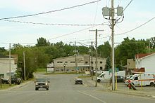 Highway 535 facing south in St. Charles
Highway 535 is a generally straight route oriented in a north–south direction through parts of the Canadian Shield and Sudbury Basin. The two lane highway begins at a junction with Highway 64 in the town of Noëlville, where it is known as David Street North. It proceeds directly north in a straight line for almost 10 kilometres (6.2 mi), crossing the Wolseley River en route. The highway eventually diverges from its straight course prior to crossing the French River at West Arm. It zigzags its way north through rough terrain for several kilometres, passing through several rock outcroppings.[3]
Eventually, the route straightens once more, then curves east and enters St. Charles. Within the village, drivers must turn at a stop sign to remain on Highway 535. From here the highway once again resumes its straight north–south alignment for 6 kilometres (3.7 mi), diverging to cross the Nepewassi River, then entering the village of Hagar, where it intersects Highway 17, the Trans Canada Highway. Immediately north of Highway 17, the route crosses the Veuve River and then a rail line. It curves through the boreal forest for over 10.3 kilometres (6.4 mi) to Rivière-Veuve, where the highway designation ends at an intersection with Sauve Road to the west and Labelle Road to the east. The roadway continues north as Boundary Road into the wilderness.[3]
History
The current route of Highway 535 was first assumed by the Department of Highways in early 1956, along with several dozen other secondary highways. It was likely maintained as a development road prior to that. It formed the final 14.2 kilometres (8.8 mi) of Highway 556.[1][4]
Major intersections
The following table lists the major junctions along Highway 535. The entirety of the route is located within Sudbury District.[3]
Location km[2] Destinations Notes Noelville 0.0 Highway 64Hagar 38.5 Highway 17 – Sudbury, Sturgeon FallsRiviere Veuve 48.8 Sauve Road / Labelle Road 1.000 mi = 1.609 km; 1.000 km = 0.621 mi References
- ^ a b "Ontario Secondary Roads Now Designated 500, 600". 112. The Globe and Mail. February 4, 1956. p. 4. "Two new Ontario road numbers appear on the province's 1956 official road map which will be ready for distribution next week. The new numbers are the 500 and 600 series and designate hundreds of miles of secondary roads which are wholly maintained by the Highways Department. More than 100 secondary roads will have their own numbers and signs this year. All of these secondary roads were taken into the province's main highways system because they form important connecting links with the King's Highways"
- ^ a b Ministry of Transportation of Ontario (2007). "Annual Average Daily Traffic (AADT) counts". http://www.raqsb.mto.gov.on.ca/techpubs/TrafficVolumes.nsf/tvweb?OpenForm&Seq=5. Retrieved May 29, 2011.
- ^ a b c Peter Heiler (2010). Ontario Back Road Atlas (Map). Cartography by MapArt. p. 105, section K17. ISBN 978-1-55198-226-7.
- ^ Ontario Department of Highways (1956). Ontario Road Map (Map). Cartography by C.P. Robins. Section O31.
Secondary highways of Ontario Secondary Highways 502 · 510 · 516 · 518 · 519 · 520 · 522 · 522B · 523 · 524 · 525 · 526 · 527 · 528 · 528A · 529 · 529A · 531 · 532 · 533 · 534 · 535 · 537 · 538 · 539 · 539A · 540 · 540A · 540B · 542 · 542A · 546 · 547 · 548 · 550 · 551 · 552 · 553 · 554 · 556 · 557 · 558 · 559 · 560 · 560A · 562 · 563 · 564 · 565 · 566 · 567 · 568 · 569 · 570 · 571 · 572 · 573 · 574 · 575 · 577 · 579 · 580 · 581 · 582 · 583 · 584 · 585 · 586 · 587 · 588 · 589 · 590 · 591 · 592 · 593 · 594 · 595 · 596 · 597 · 599 · 600 · 601 · 602 · 603 · 604 · 605 · 607 · 607A · 608 · 609 · 611 · 612 · 613 · 614 · 615 · 617 · 618 · 619 · 621 · 622 · 623 · 624 · 625 · 626 · 627 · 628 · 630 · 631 · 632 · 633 · 634 · 636 · 637 · 638 · 639 · 640 · 641 · 642 · 643 · 644 · 645 · 646 · 647 · 650 · 651 · 652 · 654 · 655 · 656 · 657 · 658 · 661 · 663 · 664 · 665 · 667 · 668 · 670 · 671 · 672 · 673
By district Algoma · Cochrane · Kenora · Manitoulin · Nipissing · Parry Sound · Sudbury · Thunder Bay · TimiskamingSee also County roads · Former highways · Historic Colonization Roads · List of Ontario provincial highways · Ministry of Transportation · Northern Ontario Resource Trail · Numbered highways in Canada · Tourist Routes · Trans-Canada HighwayCounty roads in Ontario · Ontario numbered highways · Expressways and 400-series highways · King's Highways · Secondary highways · Tertiary and 7000-series highways · List of Ontario provincial highways · List of former provincial highways in Ontario · Highways in Ontario · List of Ontario expressways · Trans-Canada Highway · Connecting Link · Emergency Detour RouteCategories:- Ontario secondary highways
- Roads in Sudbury District, Ontario


Wikimedia Foundation. 2010.