- Ontario Highway 534
-
Highway 534
Route information Length: 43.9 km[3] (27.3 mi) Existed: 1956[1][2] – present Major junctions West end: Restoule Provincial Park East end: Clark Street in Powassan Location Divisions: Nipissing District Towns: Powassan, Nipissing, Restoule Highway system Ontario provincial highways
400-series • Former←  Hwy 533
Hwy 535  →
→Secondary Highway 534, commonly referred to as Highway 534, is a provincially maintained secondary highway in the Canadian province of Ontario. The route begins at the entrance to Restoule Provincial Park and ends near Highway 11 in Powassan. The route provides access to several communities which lay south of Lake Nipissing. Between those communities, the highway travels mostly through thick boreal forest. It was assumed in 1956, following its present course and remaining unchanged since. It is a lightly travelled route accommodating, on an average day, no more than 850 vehicles.
Contents
Route description
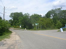 Highway 534 in Restoule, at the Restoule River bridge
Highway 534 begins in Restoule Provincial Park in Patterson Township. It travels south, curving along the eastern shore of Restoule Lake, south to the town of Restoule, where it then bends southeast and cuts through the northeast corner of Pringle Township near the community of Carr. Here it meets Highway 524, a short highway that travels south through Carr to Farleys Corners. From the junction with Highway 524, the route curves northeast into the Township of Nipissing. It passes through the community of Hotham before bending northeast to a junction with Highway 654 near the community of Nipissing. The highway then travels east through the community of Christian Valley and then Powassan, where it ends at Clark Street, east of the interchange with Highway 11.
In total, the highway is 43.9 kilometres (27.3 mi) long. The portion of the highway between Highway 524 and Highway 654 is part of the Lake Nipissing Circle Tour. The entire route is located within Parry Sound District. In 2007, the busiest section was between Highway 11 and Highway 654, which had an annual average daily traffic (AADT) count of 840, while the least busiest section was between Restoule and the western terminus, which had an AADT of 200.[3]
History
The current route of Highway 534 was first assumed by the Department of Highways in early 1956, along with several dozen other secondary highways. It was likely maintained as a development road prior to that.[2][1] The route has remained unchanged since then.[4]
Major intersections
The following table lists the major junctions along Highway 534. The entirety of the route is located within Parry Sound District.[4]
Location km[3] Destinations Notes 0.0 Patterson Lake Road Restoule Provincial Park entrance Restoule 9.0 Commanda Lake Road 13.5  Highway 524 – Carr
Nipissing 30.5 Highway 654 Powassan 43.7  Highway 11 – Toronto, North Bay
Exit 316 43.9 Clark Street 1.000 mi = 1.609 km; 1.000 km = 0.621 mi References
- ^ a b Ontario Department of Highways (1956). Ontario Road Map (Map). Cartography by C.P. Robins. Section N34–35.
- ^ a b "Ontario Secondary Roads Now Designated 500, 600". 112. The Globe and Mail. February 4, 1956. p. 4. "Two new Ontario road numbers appear on the province's 1956 official road map which will be ready for distribution next week. The new numbers are the 500 and 600 series and designate hundreds of miles of secondary roads which are wholly maintained by the Highways Department. More than 100 secondary roads will have their own numbers and signs this year. All of these secondary roads were taken into the province's main highways system because they form important connecting links with the King's Highways"
- ^ a b c Ministry of Transportation of Ontario (2007). "Annual Average Daily Traffic (AADT) counts". http://www.raqsb.mto.gov.on.ca/techpubs/TrafficVolumes.nsf/tvweb?OpenForm&Seq=5. Retrieved May 11, 2011.
- ^ a b Peter Heiler (2010). Ontario Back Road Atlas (Map). Cartography by MapArt. p. 94–95, section G29–H32. ISBN 978-1-55198-226-7.
Secondary highways of Ontario Secondary Highways 502 · 510 · 516 · 518 · 519 · 520 · 522 · 522B · 523 · 524 · 525 · 526 · 527 · 528 · 528A · 529 · 529A · 531 · 532 · 533 · 534 · 535 · 537 · 538 · 539 · 539A · 540 · 540A · 540B · 542 · 542A · 546 · 547 · 548 · 550 · 551 · 552 · 553 · 554 · 556 · 557 · 558 · 559 · 560 · 560A · 562 · 563 · 564 · 565 · 566 · 567 · 568 · 569 · 570 · 571 · 572 · 573 · 574 · 575 · 577 · 579 · 580 · 581 · 582 · 583 · 584 · 585 · 586 · 587 · 588 · 589 · 590 · 591 · 592 · 593 · 594 · 595 · 596 · 597 · 599 · 600 · 601 · 602 · 603 · 604 · 605 · 607 · 607A · 608 · 609 · 611 · 612 · 613 · 614 · 615 · 617 · 618 · 619 · 621 · 622 · 623 · 624 · 625 · 626 · 627 · 628 · 630 · 631 · 632 · 633 · 634 · 636 · 637 · 638 · 639 · 640 · 641 · 642 · 643 · 644 · 645 · 646 · 647 · 650 · 651 · 652 · 654 · 655 · 656 · 657 · 658 · 661 · 663 · 664 · 665 · 667 · 668 · 670 · 671 · 672 · 673
By district Algoma · Cochrane · Kenora · Manitoulin · Nipissing · Parry Sound · Sudbury · Thunder Bay · TimiskamingSee also County roads · Former highways · Historic Colonization Roads · List of Ontario provincial highways · Ministry of Transportation · Northern Ontario Resource Trail · Numbered highways in Canada · Tourist Routes · Trans-Canada HighwayCounty roads in Ontario · Ontario numbered highways · Expressways and 400-series highways · King's Highways · Secondary highways · Tertiary and 7000-series highways · List of Ontario provincial highways · List of former provincial highways in Ontario · Highways in Ontario · List of Ontario expressways · Trans-Canada Highway · Connecting Link · Emergency Detour RouteCategories:- Ontario secondary highways
- Roads in Parry Sound District, Ontario


Wikimedia Foundation. 2010.