- Parry Sound District
-
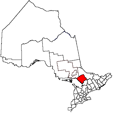
Parry Sound District — District — Location of Parry Sound District in Ontario
Coordinates: 45°42′N 79°50′W / 45.7°N 79.833°WCoordinates: 45°42′N 79°50′W / 45.7°N 79.833°W Country  Canada
Province  Ontario
Region Central Ontario Created 1870 Government – MPs Tony Clement, Jay Aspin, Claude Gravelle – MPPs Norm Miller, Monique Smith Area – Land 9,222.04 km2 (3,560.6 sq mi) Population (2006)[1] – Total 40,918 – Density 4.4/km2 (11.4/sq mi) Canada 2006 Census Time zone EST (UTC-5) – Summer (DST) EDT (UTC-4) Postal code FSA P0C, P0E, P0G, P0H, P2A Area code(s) 705 Seat Parry Sound Parry Sound District is a census division of the Canadian province of Ontario. Its seat is Parry Sound. Its boundaries are Muskoka to the south, the Sudbury District, the French River and Lake Nipissing in the north, Nipissing District, Ontario and North Bay in the north and east and parts of Algonquin Park in the northeast.
In 2006, the population was 40,918.[1] The land area is 9,222.04 square kilometres (3,561 sq mi); the population density was 4.4 per square kilometre (11 /sq mi).
Although geographically in Southern Ontario, the Parry Sound District is the only census division in the southern part of the province which does not have an incorporated county, regional municipality or district municipality level of government, instead serving as a purely territorial division like the districts of Northern Ontario.
In lieu of an upper tier of municipal administration, all government services in the district are provided either by the local municipalities or by the provincial government itself. Some communities which are not part of any incorporated municipality are served by local services boards. The district is also included in the service area of FedNor and the Northern Ontario Heritage Fund. Accordingly, in some contexts the division is grouped with the Northern Ontario region instead of Southern Ontario.
Contents
Subdivisions
Towns
- Kearney
- Parry Sound
- Powassan
Townships
- The Archipelago
- Armour
- Callander
- Carling
- Joly
- Machar
- Magnetawan
- McDougall
- McKellar
- McMurrich/Monteith
- Nipissing
- Perry
- Ryerson
- Seguin
- Strong
- Whitestone
Villages
- Burk's Falls
- South River
- Sundridge
Unorganized areas
Local services boards in the unorganized areas:
- Britt and Byng Inlet
- Laurier
- Loring, Port Loring and District
- Restoule
First Nations
- Dokis
- French River
- Henvey Inlet
- Magnetewan
- Naiscoutaing
- Parry Island or Wasauksing First Nation
- Shawanaga
Original Townships
- Armour - Still exists.
- Bethune - Annexed by the Town of Killarney.
- Blair - Still exists. Never incorporated.
- Brown - Still exists. Never incorporated.
- Burpee - Now part of the Municipality of Whitestone.
- Burton - Now part of the Municipality of Whitestone.
- Carling - Still exists.
- Chapman - Became part of the Municipality of Magnetawan.
- Christie - Now part of the Municipality of Seguin.
- Conger - Now part of the Municipality of the Archipelago and a small part is in the Municipality of Seguin.
- Cowper - Now part of the Municipality of the Archipelago.
- Croft - Most became part of the Municipality of Whitestone while a small part became part of the Municipality of Magnetawan.
- East Mills - Still exists. Never incorporated.
- Ferguson - Annexed by McDougall Township.
- Ferrie - Now part of the Municipality of Whitestone.
- Foley - Now part of the Municipality of Seguin.
- Gurd - Annexed by Nipissing Township.
- Hagerman - Now part of the Municipality of Whitestone.
- Hardy - Still exists. Never incorporated.
- Harrison - Still existsalthough most of it became part of the Municipality of the Archipelago. Never incorporated.
- Henvey - Still existsalthough its northern section was transferred to the Town of Killarney in Sudbury District. Never incorporated.
- Humphrey - Now part of the Municipality of Seguin.
- Joly - Still exists.
- Laurier - Still exists. Never incorporated.
- Lount - Still exists. Never incorporated.
- Machar - Still exists.
- McConkey - Still exists. Never incorporated.
- McDougall - Still exists, but is larger having annexed Ferguson Township.
- McKellar - Still exists.
- McKenzie - Now part of the Municipality of Whitestone.
- McMurrich - Now part of the Township of McMurrich/Monteith.
- Monteith - Western two thirds became part of the Municipality of Seguin while the eastern third became part of the Township of McMurrich/Monteith.
- Mowat - Still exists although a small section was transferred to the Town of Killarney in Sudbury District. Never incorporated.
- North Himsworth - Changed names to Callander. Now the Municipality of Callander.
- Nipissing - Still exists, but is larger having annexed Gurd Township.
- Patterson - Still exists. Never incorporated.
- Perry - Still exists.
- Pringle - Still exists. Never incorporated.
- Proudfoot - Annexed by the Town of Kearney.
- Ryerson - Still exists.
- Shawanaga - Still exists, although most of it became part of the Municipality of the Archipelago. Never incorporated.
- South Himsworth - Annexed by the Municipality of Powassan.
- Spence - Still exists. Never incorporated.
- Strong - Still exists.
- Wallbridge - Still exists. Never incorporated.
- Wilson - Still exists. Never incorporated.
Demographics
Canada census – Parry Sound District Community Profile 2006 2001 Population:
Land area:
Population density:
Median age:
Total private dwellings:
Mean household income:40,918 (3.2% from 2001)
9,222.04 km2 (3,560.65 sq mi)
4.4 /km2 (11 /sq mi)
47.9 (males: 47.3, females: 48.4)
35,404
$46,18039,665 (-0.6% from 1996)
9,222.25 km2 (3,560.73 sq mi)
4.3 /km2 (11 /sq mi)
44.2 (males: 43.7, females: 44.8)
34,931
$38,676- 93.8% White
- 5.5% Aboriginal (3.8% First Nations, 1.5% Métis)
- 0.7% Visible Minorities
Forest fire protection history
See also: wildfire suppressionThe Parry Sound Forest Fire District was founded by Ontario's former Department of Lands and Forests (now the MNR) in 1922 as one of 17 districts to help protect Ontario's forests from fire by early detection from fire towers. The headquarters for the district were housed in the town of Parry Sound. It was the central location for 21 fire tower lookouts, including the Parry Sound fire tower, which was erected in the same location as the modern lookout tower at 17 George Street. The other 20 towers in the district were: Pickerel River CPR, Byng Inlet, Still River, Pointe au Baril, Pakesley, Pickerel River CNR, Key Junction, Ardbeg, Spence, Go Home, Loring, Stormy Lake (Restoule), Nipissing, Boulter, Lount, Laurier, Strong, Proudfoot, Stisted and Draper. When a fire was spotted in the forest a towerman would get the degree bearings from his respective tower and radio back the information to headquarters. When one or more towermen from other towers in the area would also call in their bearings, the forest rangers at headquarters could get a 'triangulation' read and plot the exact location of the fire on their map. This way a team of forest firefighters could be dispatched as soon as possible to get the fire under control. In 1969 there remained only 4 actively manned towers: Ardbeg, Go Home, Stormy Lake, and Boulter. These would all be phased out shortly after when aerial fire fighting techniques were employed in the 1970s.
See also
- Canadian census divisions
- Central Ontario
References
- ^ a b Statcan 2006 Census Profile - Parry Sound District
- ^ "2006 Community Profiles". Statistics Canada. Government of Canada. 2009-02-24. http://www12.statcan.ca/census-recensement/2006/dp-pd/prof/92-591/index.cfm?Lang=E. Retrieved 2011-08-22.
- ^ "2001 Community Profiles". Statistics Canada. Government of Canada. 2007-02-01. http://www12.statcan.ca/english/profil01/CP01/Index.cfm?Lang=E. Retrieved 2011-08-22.
External links
- The Parry Sound Area Chamber of Commerce
- Parry Sound and Area information
- Map of Parry Sound District showing its municipalities
- Rooted in Stone: Reflections on West Parry Sound's Past
- Almaguin Highlands Ontario East Parry Sound's Almaguin Highlands Regional Portal
- Almaguin Highlands Digital Collection A service of Knowledge Ontario

Sudbury District Nipissing District Georgian Bay (Lake Huron) 
Nipissing District  Parry Sound District

Muskoka District Municipality Towns 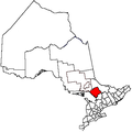
Townships The Archipelago • Armour • Callander • Carling • Joly • Machar • Magnetawan • McDougall • McKellar • McMurrich/Monteith • Nipissing • Perry • Ryerson • Seguin • Strong • WhitestoneVillages First Nations Local services boards Unorganized areas Categories:

Wikimedia Foundation. 2010.