- Frontenac County, Ontario
Infobox Settlement
name =Frontenac County
official_name =
other_name =
native_name =
nickname =
settlement_type =Upper Tier Municipality
total_type =
motto =
imagesize =
image_caption =
flag_size =
image_
seal_size =
image_shield =
shield_size =
image_blank_emblem =
blank_emblem_type =
blank_emblem_size =
imagesize =
image_caption =
flag_size =
image_
seal_size =
image_shield =
shield_size =
image_blank_emblem =
blank_emblem_type =
blank_emblem_size =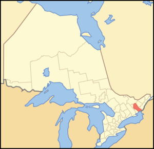
mapsize = 300px
map_caption = Location of Frontenac County
mapsize1 =
map_caption1 =
image_dot_
dot_mapsize =
dot_map_caption =
dot_x = |dot_y =
pushpin_
pushpin_label_position =
pushpin_map_caption =
pushpin_mapsize =
subdivision_type = Country
subdivision_name = CAN
subdivision_type1 = Province
subdivision_name1 = ONT
subdivision_type2 =
subdivision_name2 =
seat_type =Board HQ
seat =Kingston
parts_type =Municipalities
parts_style =
parts =
p1 =Township of Central Frontenac
p2 = Township of Frontenac Islands
p3=Township of North Frontenac
p4=Township of South Frontenac
government_footnotes =
government_type =
leader_title =
leader_name =
leader_title1 =
leader_name1 =
established_title =
established_date =
area_magnitude =
unit_pref =Imperial
area_footnotes = cite web |url=http://www12.statcan.ca/english/census06/data/profiles/community/Details/Page.cfm?Lang=E&Geo1=CD&Code1=3510&Geo2=PR&Code2=35&Data=Count&SearchText=Frontenac&SearchType=Begins&SearchPR=35&B1=All&Custom= |title=Community highlights for Frontenac |accessdate=2007-12-28 |date=2006 |work= |publisher=Government of Canada]
area_total_km2 =
area_land_km2 =3672.49
area_water_km2 =
area_total_sq_mi =
area_land_sq_mi =1417.96
area_water_sq_mi =
area_water_percent =
elevation_footnotes =
elevation_m =
elevation_ft =
elevation_max_m =
elevation_max_ft =
elevation_min_m =
elevation_min_ft =
population_as_of =2006
population_footnotes =
population_note =
population_total = 143865
population_density_km2 = 39.2
population_density_sq_mi =101.5
timezone = EST
utc_offset = -5
timezone_DST = EDT
utc_offset_DST = -4
coor_type =
latd= |latm= |lats= |latNS=
longd= |longm= |longs= |longEW=
postal_code_type =
postal_code =
area_code =613
website = [http://www.frontenaccounty.ca/ Frontenac County. Ontario, Canada]
footnotes = Frontenac County, as defined by Statistics Canada, is acensus division of theCanadian province ofOntario . The City of Kingston is included in the census division, but is separated from the County of Frontenac. Frontenac County, has a land area of convert|1417.96|sqmi|km2|2. The population in 2001 was 138,606 and in 2006 was 143,865."'The County of Frontenac, also known as Frontenac County, is an upper tier municipality in the
Canadian province ofOntario . While a traditional Ontariocounty prior to 1998, it was abolished as part of municipal restructuring and amalgamations, and replaced by a management unit with limited powers. Frontenac County does not have a county road systemFact|date=November 2007, nor does it manage social services beyond a limited scope as outlined by the province. While new development does require board approval, the board does not have the ability to outline new development themselves.The board, or "County Council", presides over these municipalities:
* Township of Central Frontenac
* Township of Frontenac Islands
* Township of North Frontenac
* Township of South FrontenacThe County has a land area of 3,220 square kilometres. The population in 2001 was 24,411 and in 2006 it was 26,658.
See also
*
List of Ontario Census Divisions References
External links
* [http://www.frontenaccounty.ca/ Frontenac County. Ontario, Canada]
Wikimedia Foundation. 2010.