North Frontenac, Ontario

North Frontenac, Ontario
North Frontenac
—  Township  —
Plevna
North Frontenac is located in Ontario
North Frontenac
Coordinates: 44°57′N 76°54′W / 44.95°N 76.9°W / 44.95; -76.9
Country  Canada
Province  Ontario
County Frontenac
Settled
Incorporated 1998
Government
 – Type Township
 – Mayor Bud Clayton
 – Federal riding Lanark—Frontenac—Lennox and Addington
 – Prov. riding Lanark—Frontenac—Lennox and Addington
Area[1]
 – Land 1,135.75 km2 (438.5 sq mi)
Population (2006)[1]
 – Total 1,904
 – Density 1.7/km2 (4.4/sq mi)
Time zone EST (UTC-5)
 – Summer (DST) EDT (UTC-4)
Postal Code K0H
Area code(s) 613
Website www.northfrontenac.com

North Frontenac is a township in Frontenac County in eastern Ontario, Canada.

North Frontenac was created in 1998 by the amalgamation of three municipalities: the Township of Barrie, the Township of Clarendon and Miller, and the Township of Palmerston, North and South Canonto.

Contents

Communities

The township includes the communities of Ardoch, Beatty, Beech Corners, Canonto, Coxvale, Donaldson, Fernleigh, Harlowe, Mississippi Station, Myers Cave, Ompah, Plevna, Robertsville, Snow Road Station and Wilbur.


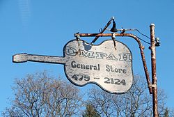
Old store sign in Ompah

Demographics

According to the 2006 Statistics Canada Census:[1]

  • Population: 1,904
  • % Change (2001-2006): 5.7
  • Area (km².): 1,135.75
  • Density (persons per km².): 1.7
  • Private dwellings occupied by usual residents: 868 (total dwellings: 3107)
  • Mother tongue:
    • English as first language: 95.3 %
    • French as first language: 0.5 %
    • English and French as first language: 0 %
    • Other as first language: 4.2 %

Population trend:[2]

  • Population in 2006: 1904
  • Population in 2001: 1801
  • Population in 1996:
    • Barrie (township): 822
    • Clarendon and Miller (township): 545
    • Palmerston and North and South Canonto (township): 406
  • Population in 1991:
    • Barrie (township): 728
    • Clarendon and Miller (township): 473
    • Palmerston and North and South Canonto (township): 393

References

  1. ^ a b c Statistics Canada 2006 Census - North Frontenac community profile
  2. ^ Statistics Canada: 1996, 2001, 2006 census

External links


Coordinates: 44°57′N 76°54′W / 44.95°N 76.9°W / 44.95; -76.9


Wikimedia Foundation. 2010.

Игры ⚽ Поможем сделать НИР

Look at other dictionaries:

  • Frontenac (Ontario electoral district) — Frontenac was a federal electoral district represented in the Canadian House of Commons from 1867 to 1925. It was located in the province of Ontario. It was created by the British North America Act of 1867. It was initially defined to consist of… …   Wikipedia

  • Central Frontenac, Ontario — Central Frontenac   Township   Road sign along Highway 7 …   Wikipedia

  • Frontenac Ventures Corporation — is a privately owned uranium mining and exploration company. Frontenac is currently working to open a new mine in North Frontenac, Ontario. [ [http://www.newsweb.ca/2007/07 34 Aug 30/judge implacable.html Judge orders Algonquin communities out] ] …   Wikipedia

  • Frontenac — ist der Name von Louis de Buade, Comté de Frontenac et de Palluau (1620 1698), Gouverneur der französischen Kolonie Neufrankreich (Kanada) Nach Frontenac wurden benannt: Orte in Kanada: Fort Frontenac, eine französische Befestigung am Ontariosee …   Deutsch Wikipedia

  • Frontenac County — Lage des Frontenac County in Ontario Provinz Ontario County Seat Kingston …   Deutsch Wikipedia

  • Frontenac Flyers — Hockey team team = Frontenac Flyers logosize = 125px city = Verona, Ontario league = Empire B Junior C Hockey League founded = 1989 arena = North Frontenac Community Centre colours = Orange, Black, and White coach = vacant GM = vacant parentclub …   Wikipedia

  • Frontenac County, Ontario — Infobox Settlement name =Frontenac County official name = other name = native name = nickname = settlement type =Upper Tier Municipality total type = motto = imagesize = image caption = flag size = image seal size = image shield = shield size =… …   Wikipedia

  • Ontario, Lake — Smallest and easternmost of the Great Lakes of North America. Bounded by New York and Ontario, and with the U.S. Canada border passing through it, the lake is roughly elliptical; its major axis, 193 mi (311 km) long, lies nearly east to west, and …   Universalium

  • Ontario electoral reform referendum, 2007 detailed results — The following tables are the detailed results of the Ontario electoral reform referendum that was held on October 10, 2007, in an attempt to establish a mixed member proportional representation (MMP) system for elections to the Legislative… …   Wikipedia

  • Ontario municipal elections, 2006 — Municipal election signs in North Bay, Ontario. In the 2006 municipal elections in Ontario, voters in the province of Ontario, elected mayors, councillors, school board trustees and all other elected officials in all of Ontario s municipalities.… …   Wikipedia

Share the article and excerpts

Direct link
Do a right-click on the link above
and select “Copy Link”