- Dufferin County, Ontario
Infobox Settlement
name =
official_name =Dufferin County
other_name =
native_name =
nickname =
settlement_type =County
total_type =
motto =
imagesize =
image_caption =
flag_size =
image_
seal_size =
image_shield =
shield_size =
image_blank_emblem =
blank_emblem_type =
blank_emblem_size =
imagesize =
image_caption =
flag_size =
image_
seal_size =
image_shield =
shield_size =
image_blank_emblem =
blank_emblem_type =
blank_emblem_size =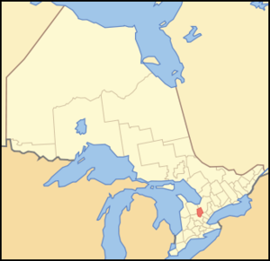
mapsize = 300px
map_caption = Location of Dufferin County
mapsize1 =
map_caption1 =
image_dot_
dot_mapsize =
dot_map_caption =
dot_x = |dot_y =
pushpin_
pushpin_label_position =
pushpin_map_caption =
pushpin_mapsize =
subdivision_type = Country
subdivision_name = CAN
subdivision_type1 = Province
subdivision_name1 = ONT
subdivision_type2 =
subdivision_name2 =
seat_type =County seat
seat =Orangeville
parts_type =Municipalities
parts_style =
parts =
p1 =Town of Mono
p2 = Town of Orangeville
p3=Town of Shelburne
p4=Township of Amaranth
p5=Township of East Garafraxa
p6=Township of East Luther Grand Valley
p7=Township of Melancthon
p8=Township of Mulmur
government_footnotes =
government_type =
leader_title =
leader_name =
leader_title1 =
leader_name1 =
established_title =
established_date =
area_magnitude =
unit_pref =Imperial
area_footnotes =
area_total_km2 =1456.1
area_land_km2 =
area_water_km2 =
area_total_sq_mi =562.2
area_land_sq_mi =
area_water_sq_mi =
area_water_percent =
elevation_footnotes =
elevation_m =
elevation_ft =
elevation_max_m =
elevation_max_ft =
elevation_min_m =
elevation_min_ft =
population_as_of =2001
population_footnotes =
population_note =
population_total =
population_density_km2 =
population_density_sq_mi =
timezone = EST
utc_offset = -5
timezone_DST = EDT
utc_offset_DST = -4
coor_type =
latd= |latm= |lats= |latNS=
longd= |longm= |longs= |longEW=
postal_code_type =
postal_code =
area_code =
website = [http://www.dufferincounty.on.ca/ www.dufferincounty.on.ca]
footnotes =
blank_name =
blank_info =
blank1_name =
blank1_info = Dufferin County is acounty andcensus division of the Canadian province ofOntario . The county seat is Orangeville, and the current Warden is MayorEarl Lennox of East Garafraxa. It covers an area of convert|359812|acre|sqmi km2|0, and its population is 54,436 (2006). The county gets its name from the Marquess of Dufferin, who wasGovernor General of Canada between 1872-1878.Dufferin County is the highest plateau immediately west of
Georgian Bay , and as such forms the watershed between the four lakes: Huron, Erie, Ontario and Simcoe. Four rivers — Saugeen, Grand, Credit and Nottawasaga — take their rise in Dufferin or in adjacent townships and drain through the county.The county is a lofty table-land that is about convert|1700|ft|m|0 above sea-level and about convert|1400|ft|m|0 above the level of
downtown Toronto . A continuation of the Caledon Mountains skirts the eastern side of the county. The highest peaks, however, are no match for the Blue Mountains north of Dufferin or the Caledon Mountains on the south.It consists of the following municipalities:
*Town of Mono
*Town of Orangeville
*Town of Shelburne
*Township of Amaranth
*Township of East Garafraxa
*Township of East Luther Grand Valley
*Township of Melancthon
*Township of MulmurHistorical townships
* Amaranth Township, area: convert|63471|acre|sqmi km2|0. Opened in 1821 and named from a common weed-plant (
Amaranth ) with green or purplish flowers, or it might be named after the "un-fading flower" of the classic poets. Settled mainly between 1840 and 1873. Communities were Orangeville, Laurel, Shelburne, Waldemar, Bowling Green
* Township of East Garafraxa, area: convert|40835|acre|sqmi km2|0. Opened in 1821. Settled mostly between 1833 and 1850. (community centre, Marsville)
* Township of East Luther, area: convert|38599|acre|sqmi km2|0. Settled mainly between 1860 and 1875. Community centres: Grand Valley, Monticello and Colbeck.
* Township of Melancthon, area: convert|74705|acre|sqmi km2|0. Opened in 1821 and named after one of the leader of the German Reformation (Philipp Melanchthon ). A swampy township like Luther so it was slow to be settled. Not generally settled until after 1850. Community centres: Melancthon, Corbetton, Riverview, Hornings Mills.
* Township of Mulmur, area: convert|70291|acre|sqmi km2|0. Opened in 1822. Origin of the name is forgotten, possibly a corruption of an Indian word or name. Settled mainly after 1867. Community centres: Mansfield, Honeywood, Terra Nova, Primrose.Source: "Province of Ontario -- A History 1615 to 1927" by Jesse Edgar Middleton & Fred Landon, copyright 1927, Dominion Publishing Company, Toronto
ee also
*
List of Ontario Census Divisions References
External links
* [http://www.dufferincounty.on.ca/ Dufferin County]
Wikimedia Foundation. 2010.