- Melancthon, Ontario
-
Melancthon — Township — Melancthon within the Dufferin County Coordinates: 44°09′N 80°16′W / 44.15°N 80.267°WCoordinates: 44°09′N 80°16′W / 44.15°N 80.267°W Country  Canada
Province  Ontario
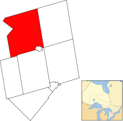
County Dufferin Settled 1818 Incorporated January 1, 1853 Government – Mayor Bill Hill – Federal riding Dufferin—Caledon – Prov. riding Dufferin—Caledon Area[1] – Land 310.88 km2 (120 sq mi) Population (2006)[1] – Total 2,895 – Density 9.3/km2 (24.1/sq mi) Time zone EST (UTC-5) – Summer (DST) EDT (UTC-4) Postal Code L0N Area code(s) 519 and 226 Website melancthontownship.ca Melancthon (2006 population 2,895) is a rural Canadian township in the northwest corner of Dufferin County, Ontario, bordered on the east by Mulmur Township, Amaranth Township and East Luther Grand Valley to the south, Southgate Township to the west, and the Municipality of Grey Highlands to the north. The township does not include the town of Shelburne on its southern border. It has one of the lowest population densities in southwestern Ontario.
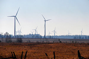
The primary industry of the township is farming, with limited beef, dairy, sheep and horse farming. It is also home to the Melancthon EcoPower Centre wind farm.
The township was founded in 1853 as a part of Grey County and transferred to Dufferin County in 1881. Township council currently comprises a mayor, a deputy mayor and three councillors.
Demographics
Population trend:[2]
- Population in 2006: 2895 (2001 to 2006 population change: 5.7 %)
- Population in 2001: 2796 (or 2739 when adjusted for 2006 boundary)
- Population in 1996: 2607
- Population in 1991: 2447
Private dwellings occupied by usual residents: 1004 (total dwellings: 1103)
References
- ^ a b "Melancthon community profile". 2006 Census data. Statistics Canada. http://www12.statcan.ca/census-recensement/2006/dp-pd/prof/92-591/details/page.cfm?Lang=E&Geo1=CSD&Code1=3522019&Geo2=PR&Code2=35&Data=Count&SearchText=Melancthon&SearchType=Begins&SearchPR=01&B1=All&Custom=. Retrieved 2011-01-18.
- ^ Statistics Canada: 1996, 2001, 2006 census
External links

Grey Highlands Clearview 
Southgate 
Mulmur  Melancthon

East Luther-Grand Valley Amaranth, Shelburne Mono Municipalities of Dufferin County, Ontario Towns Townships Categories:- Municipalities in Dufferin County, Ontario
- Township municipalities in Ontario
- Ontario geography stubs
Wikimedia Foundation. 2010.


