Nipissing District

Nipissing District
Nipissing District
—  District  —
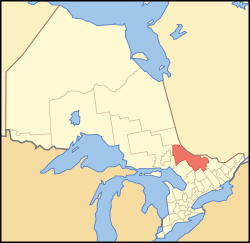
Location of Nipissing District in Ontario
Coordinates: 46°18′00″N 79°27′00″W / 46.3°N 79.45°W / 46.3; -79.45Coordinates: 46°18′00″N 79°27′00″W / 46.3°N 79.45°W / 46.3; -79.45
Country  Canada
Province  Ontario
Region Northeastern Ontario
Created 1858
Government
 - MPs Jay Aspin, Claude Gravelle, Cheryl Gallant
 - MPPs Monique Smith, David Ramsay, John Yakabuski
Area[1]
 - Total 17,065.07 km2 (6,588.9 sq mi)
Population (2006)[1]
 - Total 84,688
 - Density 5.0/km2 (12.9/sq mi)
  Canada 2006 Census
Time zone Eastern (EST) (UTC-5)
 - Summer (DST) EDT (UTC-4)
Postal code FSA P0A, P0B, P1A-P1C, P2B
Area code(s) 705
Seat North Bay

Nipissing District, Ontario is a district in Northeastern Ontario in the Canadian province of Ontario. It was created in 1858. The district seat is North Bay.

In 2006, the population was 84,688. [1] The land area is 17,065.07 km (10,603.74 mi); the population density was 5.0 people/km (8.0 people/mi), making it the most densely populated district in Northern Ontario.

Contents

Subdivisions

City

Towns

In addition, part of the town of Kearney is sometimes considered part of Nipissing District, although Statistics Canada does not consider it to be part of the census division.

Townships

Unorganized areas

First Nations

See also

References


Wikimedia Foundation. 2010.

Игры ⚽ Нужно решить контрольную?

Look at other dictionaries:

  • Nipissing District — Lage des Nipissing District in Ontario Provinz Ontario Verwaltungssitz North Bay …   Deutsch Wikipedia

  • Nipissing District, Ontario — Infobox Settlement official name = Nipissing District other name = native name = nickname = settlement type = District motto = imagesize = image caption = flag size = image seal size = image shield = shield size = city logo = citylogo size =… …   Wikipedia

  • Nipissing District municipal elections, 2010 — Elections were held in the organized municipalities in the Nipissing District of Ontario on October 25, 2010 in conjunction with municipal elections across the province. Contents 1 Bonfield 2 Calvin 3 Chisholm 4 …   Wikipedia

  • List of secondary highways in Nipissing District — This is a list of secondary highways in Nipissing District, many of which serve as logging roads or provide access to Algonquin Park and sparsely populated areas in the Nipissing District of northeastern Ontario. Contents 1 Highway 523 2 Highway… …   Wikipedia

  • Unorganized North Nipissing District — Unorganized Nipissing North Part   Unorganized territory   …   Wikipedia

  • Unorganized South Nipissing District — Unorganized Nipissing South Part   Unorganized territory   The Barron Canyon in Algonquin Park …   Wikipedia

  • Moore Creek (Nipissing District, Ontario) — For other places with the same name, see Moore Creek (disambiguation). Coordinates: 45°29′18″N 77°58′26″W / 45.48833°N 77.97389°W …   Wikipedia

  • Daisy Lake (Nipissing District, Ontario) — Coordinates: 45°39′37″N 78°56′38″W / 45.66028°N 78.94389°W / 45.66028; 78.94389 …   Wikipedia

  • Mink Lake, Nipissing District — Coordinates: 46°03′24″N 78°45′52″W / 46.05667°N 78.76444°W / 46.05667; 78.76444 …   Wikipedia

  • Sturgeon Lake (Nipissing District, Ontario) — Infobox lake lake name = Sturgeon Lake image lake = caption lake = image bathymetry = caption bathymetry= location = Nipissing District, Ontario coords = coord|46|32|41|N|79|25|05|W|region:CA ON type:waterbody|display=inline,title type = inflow …   Wikipedia

Share the article and excerpts

Direct link
Do a right-click on the link above
and select “Copy Link”