- West Nipissing
-
Coordinates: 46°22′14″N 79°55′29″W / 46.370442°N 79.924848°W
Municipality of West Nipissing — Town — Power dam on the Sturgeon River in Sturgeon Falls.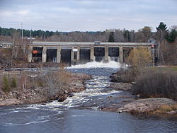

Country  Canada
Province  Ontario
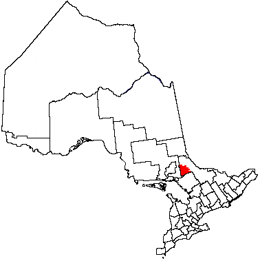
District Nipissing District Established January 1, 1999 Government – Mayor Joanne Savage – Governing Body West Nipissing Town Council – MPs Claude Gravelle (NDP) – MPPs David Ramsay (OLP) Area – Total 1,989.57 km2 (768.2 sq mi) Population (2006) – Total 13,410 – Density 6.7/km2 (17.4/sq mi) Time zone EST (UTC−5) – Summer (DST) EDT (UTC−4) Postal Code P0H, P2B Website Municipality of West Nipissing West Nipissing is a town in northeastern Ontario, Canada, on Lake Nipissing in the Nipissing District. It was formed on January 1, 1999, with the amalgamation of seventeen and a half former towns, villages, townships and unorganized communities.
It is the most bilingual community in Ontario, with 73.4% of its population fluent in both English and French.
Contents
Communities
The primary administrative and commercial centre of West Nipissing is the community of Sturgeon Falls, which is situated on the Sturgeon River, 5|km}} north of Lake Nipissing and 35 kilometres (22 mi) west of North Bay on Highway 17, part of the Trans-Canada Highway. The place got its start around 1874 as a trading post of the Hudson's Bay Company. Roughly half the entire population of West Nipissing lives in Sturgeon Falls.
 Field
Field
 Verner
Field is located on Highway 64, approximately 20 kilometres north of Sturgeon Falls. In 1979, the Sturgeon River bursted its banks, flooding the town's centre. Many houses were demolished and rebuilt on higher ground nearby. The Thistle Fire Tower is to be dismantled and re-erected here as a tourist attraction. Logging, farming and outdoor recreational activities are main village industries.
Verner is located on the Veuve River (Rivière Veuve), at the western junction of highways 17 and 64, approximately 16 kilometres (9.9 mi) west of Sturgeon Falls. The largely francophone community serves as an agricultural hub for the surrounding area and offers a consumers' cooperative and farm equipment dealers. The town was named for the wife of Canadian Pacific Railway superintendent Archer Baker, who oversaw the laying of track through the West Nipissing area in the 1880s.
Many of the francophone settlers immigrated to the area from Michigan in the late 19th century in order to preserve their language; they were concerned they would lose their language in the predominantly Anglo-centric US.
Smaller communities in the municipality include Cache Bay, Caderette, Crystal Falls, Desaulniers, Evansville, Harfred, Kirk, Lavigne, Notre Dame du Lac and River Valley. It also includes part of the North Monetville area, which straddles the boundary between West Nipissing and French River. The separate Nipissing First Nations reserve is also located near and closely associated with West Nipissing.
History
The original inhabitants of the area are the N’Biissing, an Anishinabek people, and many N’Biissing still inhabit the area today. Sturgeon Falls is the oldest community in the District of Nipissing. From 1848 to 1879, the Hudson's Bay Company operated a trading post, known as the Sturgeon River House, on the right bank of the river several hundred metres below the falls, trading with the N’Biissing for furs and other goods. James R. Holditch of Utterson, Ontario is generally credited as being the first permanent non-aboriginal settler in the area. He arrived in 1878 and built a cabin on the left bank, near the falls.
The region began to grow in the 1880s, with the arrival of the Canadian Pacific Railway (CPR) and the efforts of Fr. Charles Alfred Marie Paradis, an Oblate missionary, to develop an agricultural settlement for Franco-Ontarians in the Verner area.
The development of Sturgeon Falls began in 1881 with the arrival of Canadian Pacific Railway construction crews. The area's first post office was opened in Sturgeon Falls in 1881. Lumbering and the establishment of pulp and paper industries accelerated the village's growth and attracted many French-Canadian settlers to the area. [1]
The erection of sawmills and the rapid growth of the lumbering and pulp and paper industries stimulated the development of the village and attracted many French-Canadian settlers to the area. The town of Sturgeon Falls was incorporated on April 16, 1895. At the time, J. A. Lévis was elected the first mayor and the population was 850.
The community of Field suffered two significant natural disasters in the 1970s. On August 20, 1970, it was hit by a small tornado associated with the Sudbury, Ontario tornado event. In the spring of 1979 the Sturgeon River overflowed its banks at Field, causing massive flooding in the town's centre. Half the town that was located in the flood plain was relocated to higher ground two kilometres south of the original town centre on Highway 64. This new location is known as New Field (Val des Arbres).
Media
The region is served primarily by broadcast stations from North Bay and Sudbury. One commercial radio station, CFSF, broadcasts from Sturgeon Falls, as does a retransmitter of the SRC television affiliate CBLFT. Le5 Communications received CRTC approval on January 6, 2011 to launch a new French language radio station in the region.[2]
The area has a bilingual weekly newspaper, The West Nipissing Tribune, which was previously called The Sturgeon Falls Tribune. It is also served by the daily North Bay Nugget.
People
- Harry Bain, former paediatrician-in-chief of the Hospital for Sick Children and the University of Toronto's department chairman of paediatrics
- Jean-Jacques Blais, former cabinet member in the Canadian government
- Louise Charron, first Franco-Ontarian justice of the Supreme Court of Canada
- Jean Éthier-Blais, writer and literary critic at Le Devoir[3]
- France Gareau, 1984 Olympics athlete who won a silver medal in the 4x100 metres sprints
- François Larocque, Canadian lawyer and academic
- Carl Legault, former federal politician
- Moe Mantha, Sr., former NHL player and politician
- Moe Mantha, Jr., former NHL player, raised in Sturgeon Falls
- Denise Meehan, founder and operator of the Lick's Homeburgers hamburger chain
- André Paiement, singer and songwriter
- Lise Paiement, director of L'écho d'un Peuple, famous franco-Ontarian theatre play[4]
- Rachel Paiement, singer and songwriter
- Benoît Serré, former federal politician
- Gaetan Serré, former federal politician
References
- ^ http://www.heritagefdn.on.ca/userfiles/HTML/nts_1_6640_1.html Ontario Heritage Trust Founding of Sturgeon Falls
- ^ Broadcasting Decision CRTC 2011-2
- ^ McGill Reporter - Volume 28 Number 8
- ^ Professionally Speaking - June 2004
External links
Cities 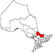
Towns Mattawa • Temagami • West NipissingTownships First Nations reserves Unorganized territories See also: Communities in Nipissing District • Census divisions of OntarioCategories:- West Nipissing
- Ontario communities with large francophone populations
- Hudson's Bay Company trading posts


Wikimedia Foundation. 2010.