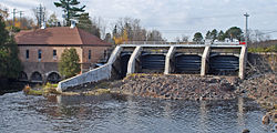
- Crystal Falls Dam and Power Plant
-
Crystal Falls Dam and Power Plant

Location: Paint River off Powerplant Road, Crystal Falls, Michigan Coordinates: 46°6′22″N 88°20′5″W / 46.10611°N 88.33472°WCoordinates: 46°6′22″N 88°20′5″W / 46.10611°N 88.33472°W Area: 1 acre (0.40 ha) Built: 1891 Governing body: Local MPS: Iron County MRA NRHP Reference#: 83003678[1] Added to NRHP: December 22, 1983 The Crystal Falls Dam and Power Plant is a utility located on the Paint River off Powerplant Road, on the north side of Crystal Falls, Michigan. It was listed on the National Register of Historic Places in 1983.[1]
History
The section of the Paint River where the dam is now located was once a the series of falls and rapids that gave Crystal Falls its name.[2] However, in 1891, the village of Crystal Falls constructed the Crystal Falls dam and power plant, effectively submerging the rapids.[2][3] They were leased to C.T. Roberts from 1891 to 1896, after which the village took over management of the plant.[3] In 1902-1903, a new power plant was constructed.[4] The plant was expanded in 1907, and new generators were installed in 1914 and 1924.[4] The plant was expanded several times; however, the output could not keep up with demand, and starting in 1929, Crystal Falls purchased supplemental power from the Wisconsin Energy Corporation.[3]
After 1929, the power plant and dam were upgraded multiple times, including a 1931 installation of a new concrete dam installed containing the rollway and tainter gates and a 1996 resurfacing of the spillway.[4] The Crystal Falls Power Plant is still operational, and is likely the oldest hydro-electric plant still in operation in the Upper Peninsula.[3] It provides roughly 1/3 of the power demanded by the residents of Crystal Falls.[2]
Description
The Crystal Falls Power Plant is a two-story structure measuring approximately thirty feet by sixty feet with a hipped roof.[3] The power plant is constructed of yellow brick with sandstone trim and sits on a concrete foundation.[3] The adjacent concrete dam spanning the Paint River measures approximately seventy-five feet long and fifteen feet high, and has four spillway sections.[3]
References
- ^ a b "National Register Information System". National Register of Historic Places. National Park Service. 2009-03-13. http://nrhp.focus.nps.gov/natreg/docs/All_Data.html.
- ^ a b c "The Falls". Crystal Falls Electric Department. http://www.crystalfalls.org/falls.htm. Retrieved November 23, 2010.
- ^ a b c d e f g "Crystal Falls Dam and Power Plant". Michigan State Housing Development Authority: Historic Sites Online. http://www.mcgi.state.mi.us/hso/sites/7003.htm. Retrieved November 20, 2010.
- ^ a b c "Power Plant History". Crystal Falls Electric Department. http://www.crystalfalls.org/Electric%20Info/History%20of%20the%20Power%20Plant.htm. Retrieved November 23, 2010.
U.S. National Register of Historic Places Topics Lists by states Alabama • Alaska • Arizona • Arkansas • California • Colorado • Connecticut • Delaware • Florida • Georgia • Hawaii • Idaho • Illinois • Indiana • Iowa • Kansas • Kentucky • Louisiana • Maine • Maryland • Massachusetts • Michigan • Minnesota • Mississippi • Missouri • Montana • Nebraska • Nevada • New Hampshire • New Jersey • New Mexico • New York • North Carolina • North Dakota • Ohio • Oklahoma • Oregon • Pennsylvania • Rhode Island • South Carolina • South Dakota • Tennessee • Texas • Utah • Vermont • Virginia • Washington • West Virginia • Wisconsin • WyomingLists by territories Lists by associated states Other  Category:National Register of Historic Places •
  Portal:National Register of Historic PlacesCategories:
- National Register of Historic Places in Michigan
- Buildings and structures completed in 1891
- Buildings and structures in Iron County, Michigan
- Dams on the National Register of Historic Places
- Dams in Michigan
Wikimedia Foundation. 2010.

