Nipissing 10, Ontario

Nipissing 10, Ontario

Coordinates: 46°20′34″N 79°49′18″W / 46.342645°N 79.821626°W / 46.342645; -79.821626

Community centre in Garden Village
Waterfront on Lake Nipissing in Garden Village

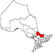
Nipissing 10 is a First Nations reserve in northeastern Ontario, Canada located on the north shores of Lake Nipissing in Nipissing District, serving as the land base for the Nipissing First Nation. The 21,007.3 hectares (51,910 acres) reserve is located west of North Bay and east of West Nipissing.

The reserve comprises the communities of Beaucage and Garden Village. Beaucage is located directly on Highway 17, while Garden Village is accessible by municipal streets in Sturgeon Falls.

Garden Village was depicted in the comic strip For Better or for Worse, as the community where Elizabeth Patterson did her practice teaching while studying education at North Bay's Nipissing University.

Demographics

According to the Canada 2006 Census[1]:

  • Population: 1,413
  • % Change (2001-2006): 2.5
  • Dwellings: 652
  • Area (km²): 61.22
  • Density (persons per km²): 23.1

References

  1. ^ Statistics Canada 2006 Community Profiles

External links


Wikimedia Foundation. 2010.

Игры ⚽ Поможем решить контрольную работу

Look at other dictionaries:

  • Nipissing District, Ontario — Infobox Settlement official name = Nipissing District other name = native name = nickname = settlement type = District motto = imagesize = image caption = flag size = image seal size = image shield = shield size = city logo = citylogo size =… …   Wikipedia

  • Moore Creek (Nipissing District, Ontario) — For other places with the same name, see Moore Creek (disambiguation). Coordinates: 45°29′18″N 77°58′26″W / 45.48833°N 77.97389°W …   Wikipedia

  • Daisy Lake (Nipissing District, Ontario) — Coordinates: 45°39′37″N 78°56′38″W / 45.66028°N 78.94389°W / 45.66028; 78.94389 …   Wikipedia

  • Sturgeon Lake (Nipissing District, Ontario) — Infobox lake lake name = Sturgeon Lake image lake = caption lake = image bathymetry = caption bathymetry= location = Nipissing District, Ontario coords = coord|46|32|41|N|79|25|05|W|region:CA ON type:waterbody|display=inline,title type = inflow …   Wikipedia

  • Canoe Lake (Nipissing District, Ontario) — Infobox lake lake name = Canoe Lake image lake = caption lake = image bathymetry = caption bathymetry= location = Algonquin Park, Nipissing District, Ontario coords = coord|45|32|56|N|78|43|4|W|region:CA ON type:waterbody|display=inline,title… …   Wikipedia

  • Nipissing District —   District   Location of Nipissing District in Ontario …   Wikipedia

  • Adanac, Nipissing District, Ontario — Adanac is a community on Lake Temagami in northeastern Ontario. Adanac is in the Town of Temagami, in the District of Nipissing. The name is derived from Canada, spelled backwards. Adanac has numerous camp sites that tourists use during the… …   Wikipedia

  • Ontario Highway 539A — Highway 539A Route information Maintained by the Ministry of Transportation of Ontario Length: 5.8 km …   Wikipedia

  • Nipissing River — Coordinates: 46°00′22″N 78°31′01″W / 46.00611°N 78.51694°W / 46.00611; 78.51694 …   Wikipedia

  • Nipissing sills — associated with Ungava magmatic event The Nipissing sills, also called the Nipissing diabase, is a large 2217– to 2210–million year old group of sills in the Superior craton of the Canadian Shield in Ontario, Canada …   Wikipedia

Share the article and excerpts

Direct link
Do a right-click on the link above
and select “Copy Link”