- Chapleau, Ontario
-
Chapleau — Township — The railway yard cuts through the centre of Chapleau.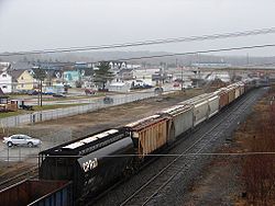
Motto: Prosperity, Industry 
 Chapleau
Coordinates: 47°50′N 83°24′W / 47.833°N 83.4°WCoordinates: 47°50′N 83°24′W / 47.833°N 83.4°W Country  Canada
Province  Ontario
District Sudbury Established 1885 Government – Type Township – Mayor Andre Byham – MP Carol Hughes (NDP) – MPP Michael Mantha (NDP) Area[1] – Land 14.27 km2 (5.5 sq mi) Population (2006)[1] – Total 2,354 – Density 165.0/km2 (427.3/sq mi) Time zone EST (UTC-5) – Summer (DST) EDT (UTC-4) Postal code span P0M 1K0 Area code(s) 705 (864 exchange) Website www.chapleau.ca Chapleau is a township in Sudbury District, Ontario, Canada. It is home to one of the world's largest wildlife preserves. Chapleau has a population of 2,354 according to the Canada 2006 Census.
The major industries within town are the logging mill, Tembec, and the Canadian Pacific Railway railyards.
Contents
Geography and location
Chapleau is located in central Northeastern Ontario, in the heart of the Canadian Shield. Chapleau is geographically isolated; the nearest cities are Sault Ste. Marie, Timmins, and Sudbury, but all are more than a two hour drive away. Highway 129 links the town with Highway 101, running east to Timmins and west to Wawa. Highway 129 also runs south, connecting with the Trans-Canada Highway, Highway 17 at Thessalon, 227 km from Chapleau.
Three First Nation reservations are located near the township: Chapleau Cree First Nation, Brunswick House First Nation, and Chapleau Ojibway First Nation.
Chapleau Crown Game Preserve
Chapleau Crown Game Preserve to the north of the town is, at over 7,000 square kilometres, the largest animal preserve in the world. Protected wildlife include moose, black bears, pygmy shrews, bald eagles and loons. The preserve is a source of tourism, drawing nature-enthusiasts and fishermen to the township. All forms of hunting and trapping have been forbidden in the preserve since the 1920s. The result is an area with abundant wildlife. In fact, over 2,500 moose and over 2,000 black bears reside within the game preserve. Logging does occur within the preserve, as does fishing. There are two provincial parks and cottages located within the preserve.
Climate
Climate data for Chapleau Month Jan Feb Mar Apr May Jun Jul Aug Sep Oct Nov Dec Year Humidex 6 9 19 27.8 34 40.8 41.8 41 37.2 29.2 18 10.7 41.8 Record high °C (°F) 5
(41)10.5
(50.9)19
(66)30
(86)32.5
(90.5)36.5
(97.7)35
(95)34
(93)31
(88)25.5
(77.9)18.3
(64.9)22
(72)36.5
(97.7)Average high °C (°F) −9.7
(14.5)−6.5
(20.3)−0.5
(31.1)7.6
(45.7)16.2
(61.2)21
(70)23.3
(73.9)21.6
(70.9)15.8
(60.4)8.4
(47.1)0.2
(32.4)−6.5
(20.3)7.6 Daily mean °C (°F) −16
(3)−13.2
(8.2)−7.2
(19.0)1.4
(34.5)9.4
(48.9)14.5
(58.1)17
(63)15.7
(60.3)10.6
(51.1)3.9
(39.0)−3.8
(25.2)−11.8
(10.8)1.7 Average low °C (°F) −22.4
(−8.3)−19.9
(−3.8)−13.8
(7.2)−4.8
(23.4)2.5
(36.5)8
(46)10.6
(51.1)9.8
(49.6)5.3
(41.5)−0.6
(30.9)−7.8
(18.0)−17.1
(1.2)−4.2 Record low °C (°F) −50
(−58)−43.5
(−46.3)−41.5
(−42.7)−24
(−11)−9.5
(14.9)−6
(21)−3
(27)−1
(30)−7.5
(18.5)−17
(1)−31
(−24)−42
(−44)−50
(−58)Wind chill −44.5 −45.7 −40.8 −30.2 −9.9 −4.4 −0.5 1 −6 −14.2 −30.2 −41.4 −45.7 Precipitation mm (inches) 55.9
(2.201)41.1
(1.618)48.5
(1.909)46.3
(1.823)72.7
(2.862)76.8
(3.024)86.7
(3.413)76.2
(3)87.8
(3.457)78.3
(3.083)60.1
(2.366)66.2
(2.606)796.6
(31.362)Rainfall mm (inches) 1.6
(0.063)2
(0.08)13.1
(0.516)24.1
(0.949)69.5
(2.736)76.8
(3.024)86.7
(3.413)76.2
(3)87.4
(3.441)69.1
(2.72)22.6
(0.89)2.6
(0.102)531.8
(20.937)Snowfall cm (inches) 58.3
(22.95)41.1
(16.18)36.8
(14.49)21.8
(8.58)3.3
(1.3)0
(0)0
(0)0
(0)0.5
(0.2)8.5
(3.35)39.4
(15.51)67.2
(26.46)276.9
(109.02)Source: Environment Canada[2] History
The first European settlement in the area was established in 1777 by the Hudson's Bay Company. The settlement was a fur trading post about 50 miles to Chapleau's north, on Big Missinabi Lake.
In 1885 the Canadian Pacific Railway was built through the area. The CPR chose this as a division point, and the town was founded. It was named in honour of Sir Joseph-Adolphe Chapleau (born November 7, 1840; died June 13, 1898), lawyer, journalist, businessman, politician, and most notably the 5th Premier of Quebec.
After a fire in 1948, the government was prompted to construct a road to Chapleau to enable logging contractors to truck timber before it rotted. The Chapleau Road (now Highway 129) was completed on January 28, 1949. In the early 1960s, Highway 101 was completed to link Chapleau with Timmins to the east, and Wawa to the west.[3][4]
Chapleau also developed logging mills, but over-exploitation of natural resources has led to many layoffs and difficult times for the town. At its largest, with large CPR and logging operations, the town had a population of 5000. However, the town has been gradually shrinking since 1950.
Demographics
Canada census – Chapleau, Ontario Community Profile 2006 2001 Population:
Land area:
Population density:
Median age:
Total private dwellings:
Mean household income:2354 (-16.9% from 2001)
14.27 km2 (5.51 sq mi)
165.0 /km2 (427 /sq mi)
40.0 (males: 39.9, females: 40.1)
1136
$58,7632832 (-3.5% from 1996)
15.02 km2 (5.80 sq mi)
188.6 /km2 (488 /sq mi)
35.9 (males: 35.9, females: 35.8)
1179
$47,941Population trend:[7]
- Population in 2006: 2354
- Population in 2001: 2832
- Population in 1996: 2934
- Population in 1991: 3077
Education
The town has two high schools, Chapleau High School and École Secondaire Catholique Trillium, and three elementary schools, Chapleau Public School, École du Sacré-Cœur, and Our Lady of Fatima. Chapleau High and Chapleau Public belong to the Algoma District School Board, the others belong to the French and English Catholic school boards.
Wireless mesh Internet
Starting on November 9, 2005, Chapleau residents began testing a wireless mesh Internet technology in a program called Project Chapleau. This Wi-Fi connection covered the entire town and was the first of its kind in Canada.
This service was designed and implemented by Bell Canada Enterprises, Nortel Networks, and the Township of Chapleau.
In April, 2007, Project Chapleau concluded without a reason being given. The Project Chapleau office (The Chapleau Innovation Center) was converted into a public internet access point, with job search and community networking facilities.
Media
All of the township's regular broadcast media are rebroadcasters of signals from Sudbury, Timmins or Wawa. The township's only purely local media service is a special station which airs information from the municipal government in the event of a weather or industrial emergency. The station does not broadcast on a regular basis; in the event of an emergency, the municipal fire service activates its fire sirens to alert residents to tune in the station.[8]
Radio
- FM 89.9 – CBCU, CBC Radio One
- FM 91.9 – CBON-28, Première Chaîne
- FM 92.7 – CHIM-8, Christian
- FM 93.7 – CFJW, emergency alert
- FM 95.9 – CHAP, community-owned rebroadcaster of CHYC-FM Sudbury[9]
- FM 100.7 – CJWA-1, adult contemporary
Television
- Channel 7: CBCU – CBC Television
- Channel 9: CITO-TV-4 – CTV
- Channel 13: CBLFT-22 – Radio-Canada
Notable people
- Floyd Curry (1925–2006), NHL player and four-time Stanley Cup winner
- Rick Norlock, federal Member of Parliament
- Jason Ward, 1997 first-round draft pick of the Montreal Canadiens
- Robert Deluce, airline executive and current president and CEO of Porter Airlines. [[1]]
References
- ^ a b "Chapleau community profile". 2006 Census data. Statistics Canada. http://www12.statcan.gc.ca/census-recensement/2006/dp-pd/prof/92-591/details/page.cfm?Lang=E&Geo1=CSD&Code1=3552092&Geo2=PR&Code2=35&Data=Count&SearchText=chapleau&SearchType=Begins&SearchPR=01&B1=All&Custom=. Retrieved 2011-04-13.
- ^ Environment Canada — Canadian Climate Normals 1971–2000, accessed 2011-04-13
- ^ "Information About Chapleau". Chapleau community portal. http://www.chapleau.ca/portal/en/visitors?paf_gear_id=1000025&itemId=2500419&returnUrl=%2Fportal%2Fen%2Fvisitors. Retrieved 2011-04-13.
- ^ Ontario Department of Highways (1956). Ontario Road Map [map]. Cartography by C.P. Robins. Section J13–14
- ^ "2006 Community Profiles". Statistics Canada. Government of Canada. 2009-02-24. http://www12.statcan.ca/census-recensement/2006/dp-pd/prof/92-591/index.cfm?Lang=E. Retrieved 2011-04-13.
- ^ "2001 Community Profiles". Statistics Canada. Government of Canada. 2007-02-01. http://www12.statcan.ca/english/profil01/CP01/Index.cfm?Lang=E. Retrieved 2011-04-13.
- ^ Statistics Canada: 1996, 2001, 2006 census
- ^ CFJW-FM launch announcement, August 31, 2007.
- ^ CRTC Decision 2007–70
External links
Towns 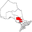
Townships First Nations Indian Reserves Chapleau 61A • Chapleau 74 • Chapleau 74A • Chapleau 75 • Duck Lake • Mattagami • Mountbatten • Whitefish Lake • Whitefish RiverUnorganized area Unorganized North PartCategories:- Township municipalities in Ontario
- Municipalities in Sudbury District, Ontario
- Ontario communities with large francophone populations
- Hudson's Bay Company trading posts


Wikimedia Foundation. 2010.