- Whitewater Region
-
Township of Whitewater Region — Township — Highway 17 through Cobden.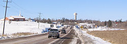
Coordinates: 45°43′N 76°50′W / 45.717°N 76.833°WCoordinates: 45°43′N 76°50′W / 45.717°N 76.833°W Country  Canada
Province  Ontario
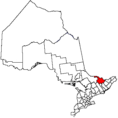
County Renfrew Established 2001 Government – Type Township – Mayor Donald Rathwell – Governing Body Township of Whitewater Region Council – MP Cheryl Gallant (CPC) – MPP John Yakabuski (OPC) Area – Total 537.96 km2 (207.7 sq mi) Population (2006)[1] – Total 6,631 – Density 12.3/km2 (31.9/sq mi) Time zone EST (UTC-5) – Summer (DST) EDT (UTC-4) Postal code span K0J Area code(s) 613 Website www.whitewaterregion.ca Whitewater Region is a township located within the scenic Ottawa Valley, in eastern Ontario, Canada on the Ottawa River in Renfrew County. Whitewater Region is made up of the former municipalities of Beachburg, Cobden, Ross and Westmeath, which were amalgamated into the current township on January 1, 2001.
Whitewater Region is named after the stretch of world famous whitewater on the Ottawa River, popular for rafting and kayaking. This section is part of the Ottawa River Provincial Park.
The township also claims a distinctive place in Canada’s history. An astrolabe bearing the date 1603 and believed to have belonged to Samuel de Champlain was discovered within the township. A monument commemorating this historic site is located just outside Cobden on Highway 17.
Contents
Communities
The township comprises the communities of Beachburg, Chenaux, Cobden, Finchley, Foresters Falls, Garden of Eden, The Glen, Grants Settlement, Haley Station, Kerr Line, La Passe, Ledgerwoods Corner, McLarens Settlement, Meath, Millars Corner, Perretton, Pleasant Valley, Queens Line, Rocher Fendu, Shields Crossing, Snake River and Westmeath.
Beachburg
 Beachburg
Beachburg (45°44′00″N 76°51′30″W / 45.7333333°N 76.85833°W) is one of the larger population centres in Whitewater Region, having a variety of stores and restaurants, an arena, several halls, a public elementary school and a public library. It was founded by and named after David Beach, and became a stop along the Canadian Northern Railway line with a station and grain elevators.1853, the entire village, except for 2 houses, was destroyed by fire. Beachburg was devastated by another fire in 1931, destroying the station, the grain elevators, the Main Hall and Dining Hall of the Exhibition Park. In 1959, the Village of Beachburg was separated from Westmeath Township and incorporated. [1]
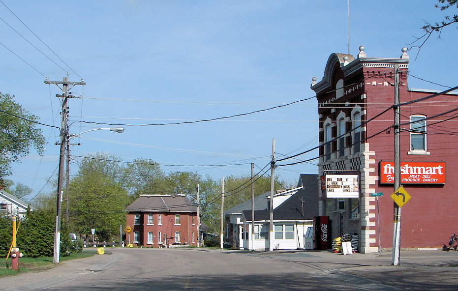
Cobden
Foresters Falls
Foresters Falls (45°40′40″N 76°47′00″W / 45.67778°N 76.7833333°W) was founded in the early 1840s by Oliver Forester, a prominent pioneer who was the community's first postmaster. By the 1870s the community had three stores, a grist mill, and a sawmill, all of which were destroyed in a fire later that same year. Foresters Falls is now a small community having regressed significantly since the invention of motorized transport. Attractions include the Ross Township Museum that is located conveniently in the heart of Foresters Falls.[2]
Haley Station
Haley Station (also known as Haley, Haleys, Haley's, with or without Station)(45°33′45″N 76°46′35″W / 45.5625°N 76.77639°W) derives its name from a station built on the CPR where the railway right of way crossed the farm of George Haley, an early settler on the second concession of Ross township (now part of Whitewater township). Haley Station once boasted a blacksmith shop, a general store, two churches (United Church and Free Methodist), two service stations, a railway station and an Orange Hall. With the advent of the automobile, people found it more convenient to go to Renfrew. Of the establishments mentioned, only the United Church remains in operation.
McLaren’s Settlement
McLaren’s Settlement (45°37′10″N 76°42′20″W / 45.61944°N 76.70556°W) originated in the 1840s when members of the McLaren family came to the area from Scotland. It was located a short distance upstream from the present OPG Cheneaux Generating Station. The McLarens arrived during the peak of the lumbering industry in the Ottawa Valley and one of their number constructed a timber slide in the Ottawa River to facilitate the movement of squared timber rafts past the Cheneaux Rapids. These slides could be described as a sluice about 50 feet wide and about 200 feet long and steeply sloped through which some river water was diverted. Floating bundles of about 25 pieces of squared timber would be steered toward the upper end of the slide. Once into the sluice, the bundle of timber would descend at a great speed, emerging undamaged into the river below the rapids. Home of the Great Nathan Clarke.
History
Founding and development
Much of the early development in Renfrew County is largely a circumstance of location. As Pembroke and Ottawa grew so, it seemed, did the gap between them. In the 1800s the easiest route between the two was the Ottawa River. However, the presence of rapids near Portage du Fort necessitated a land route. At this time the area was mostly a vast forest untouched by Europeans. A few settlers had put down near Muskrat Lake, but for the most part there had been little activity since Champlain's visit in the 17th century.
In 1849 Jason Gould built a road from what came to be called Goulds Landing to what would become Cobden on Muskrat Lake. One could catch a steamer down the lake and then go on by road to Pembroke. The traffic on the road couldn't help but cause growth. In 1850 Gould built a Post Office and named the fledgling settlement Cobden after Richard Cobden, a member of British Parliament whom Gould admired. By October 2, 1876, the railway had crept its way to Cobden. The community started to expand from the lake towards the railway station further inland. Main Street began to take shape: the Cobden Sun, the Bank of Ottawa, blacksmith shops, a bakery, a general store, a mill, a surgeon and a jewelry store were all located in the community.
In 1880 a public school as opened to accommodate the strain on nearby S.S. No 1. Cobden was soon the biggest community in Ross Township, and became an incorporated village in October 1901.
Cobden has been the victim of many fires, which have destroyed almost all of the original buildings. Main Street has suffered worst from fire including one in 1913 which destroyed the Cobden Sun building and many historical records.
A hydro electric dam began operating at the falls south of Cobden. It supplied the town, off and on, with power until it was destroyed on April 12, 1934 in a raging flood. Large blocks of ice ripped the dam apart and poured over Highway 17, tearing away sections of pavement. The plant operator, Bill Wall, was stranded in the upper section of their house until flooding subsided. The town then started receiving power from a station in Calabogie.
Council elections in 1949 were dominated by the issue of whether or not to hold another plebiscite on establishing a waterworks system. A previous plebiscite had come out 82-56 against. But times were changing quickly — after the war a new council was elected and the next vote was 124-46 in favour and by the early 1950s Cobden had water. The waterworks system required constant maintenance up until a major retooling in the 1980s. The visibly dominating water tower was built in 1988 replacing the original (built in 1951).
A bigger school was needed by 1903. The present-day school, Cobden District Public, was built in 1938 and initially served as a high school until Opeongo High School was built.
The Astrolabe
In 1613, French explorer Samuel de Champlain, traveled through an area very near Cobden while exploring the Ottawa River. Due to the Chenaux Rapids, Champlain and his men were forced to portage. They presumably took shore in Browns Bay near present day McKenzie's Hill. In 1953 a large rock was found in this area bearing a chiseled inscription. Though the inscription was hard to read it was determined that it said "Champlain Juin 2, 1613". Champlain's trail from this point is debatable. He may have cut straight across land to the southern tip of Jeffreys Lake, or he may have veered south skirting the far side of what later came to be known as the Champlain Trail Lakes. It is known that he eventually made his way to Green Lake and at this point, according to several 17th century authors, Champlain lost his astrolabe. It stayed there for 254 years, until it was found in 1867 by Edward George Lee, a 14-year-old farm boy helping his father clear trees near Green Lake (now Astrolabe Lake). Lee gave the astrolabe to Captain Comley, a steamboat captain on Muskrat Lake, but never received the ten dollars Cowley promised him, and Cowley sold the astrolabe to his employer, R.W. Cassels of the Ottawa Forwarding Company. The astrolabe eventually passed to Samuel V. Hoffman of the New York Historical Society in 1942, remaining there for 47 years until it was acquired by the Canadian Museum of Civilization in 1989.
In 1990 a special celebration was held in Cobden in honour of the astrolabe's return.
Culture
The Cobden Farmers' Market, first organized in 1991, is an outdoor market that runs from May to October. It offers a wide variety of crafts and foodstuffs and everything must be grown or handmade locally. The market has recently moved from the Memorial Hall grounds to the Fair Grounds but the Christmas Market, the grande finale for the year, is held in the Ag Hall, also on the Fair Grounds.
Overlooking Muskrat Lake, Cobden Park occupies what is thought to be the spot where Champlain met the Native Chief Nibachis. A plaque was erected in the 1960]s commemorating this. The lands for the park were donated by Thomas Robinson and his wife in 1904. In 1988 extensive work was carried out on the beach portion of the park by the Civitans.
Logos Land is a religious based water park. Built on the site of the Astrolabe's discovery, Logos Land features five water slides, paddle boats, mini-golf and a representation of Noah's Ark which was recently outfitted with a Pizza Hut Express. The water park is open mid-June to Labour Day, but Noah's Ark is open year-round. It's also home to Canada's tallest Christmas tree standing 75 feet high. Every year over 3000 local kids get together to decorate the tree. The tree is dedicated to children around the world.
Mussie is a Nessie-like creature said to reside in Muskrat Lake. It most likely doesn't exist, and if it does, is more likely a sturgeon.
Ottawa Valley Pentecostal Camp is a Christian based family and children's camp at the bottom of Muskrat Lake. It as hosted many local community events with its year round facilities. OVPC is owned and operated by the Pentecostal Assemblies of Canada.
Storyland once featured 200 animated characters set in 40 different fairy tale scenes surrounded by a natural woodland environment. Though the park has fallen into disrepair it still features two large playgrounds, paddleboats, mini-golf and picnic areas. The Champlain Lookout offers a panoramic view of the Ottawa River.
Transportation
The only provincial highway directly serving the township is Highway 17, the main route of the Trans-Canada Highway through Ontario. The planned extension of Highway 417 to Petawawa will see the highway largely rerouted onto a new alignment through Whitewater Region.
Home to The Champlain Flying Club, the Cobden/Bruce McPhail Memorial Airport is located on Highway 17.
Municipal Council
The municipal council, situated in Cobden and headed by mayor Donald Rathwell, is composed of representatives from all four wards.
- Ward 1 (formerly part of Westmeath Township) represented by Jim Labow and Jacob Rook.
- Ward 2 (also part of the former Westmeath Township) by Joseph Trimm and Izett McBride.
- Ward 3 (comprising parts of the former Westmeath and Ross townships) by Daryl McLaughlin and deputy Mayor Ron Lowe.
- Ward 4 (the remainder of the former Ross township) by Arthur Cobb and Jack Ferguson.
Demographics
According to the 2001 Statistics Canada Census:
- Population: 6,520
- % Change (1996-2001): -0.9
- Dwellings: 2,898
- Area (km²): 537.96
- Density (persons per km²): 12.1
Notable people
Cobden is the hometown of Susie Laska, former professional hockey player for the NWHL; Lee Fraser, president of Canadians Abroad and Hollywood entertainment executive; and Robert Wellington Mayhew, the first Canadian ambassador to Japan.
References
- ^ "Beachburg community profile". Township of Whitewater Region. http://www.whitewaterregion.ca/communities/beachburg.htm. Retrieved 2008-05-09.
- ^ Kennedy, Clyde C. Upper Ottawa Valley: Glimpse of History. Pembroke, Ont.: Renfrew County Council, 1970.
External links

Ottawa River /
L'Isle-aux-Allumettes, QuebecOttawa River / Waltham, Quebec Laurentian Valley 
Ottawa River / L'Île-du-Grand-Calumet, Quebec  Whitewater Region

Admaston Bromley Horton Cities Pembroke 1
Towns Townships First Nations reserves See also: Communities in Renfrew County • Census divisions of Ontario
1 Separated municipality but remains a census subdivision of the countyCategories:- Municipalities in Renfrew County, Ontario
- Township municipalities in Ontario

Wikimedia Foundation. 2010.