- Dryden, Ontario
-
Dryden — City — Dryden mill
Nickname(s): D-Town 
 Dryden
Coordinates: 49°47′N 92°50′W / 49.783°N 92.833°WCoordinates: 49°47′N 92°50′W / 49.783°N 92.833°W Country  Canada
Province  Ontario
District Kenora Settled 1895 Incorporated 1910 (town) Incorporated 1998 (city) Government – Mayor Craig Nuttall – Governing Body Dryden Council – MPs Greg Rickford – MPPs Howard Hampton Area[1] – Land 65.20 km2 (25.2 sq mi) Elevation[2] 371.90 m (1,220 ft) Population (2006)[1] – Total 8,195 – Density 125.7/km2 (325.6/sq mi) Time zone CST (UTC-6) – Summer (DST) CDT (UTC-5) Postal code P8N Area code(s) 807 Website www.dryden.ca Dryden is the second-largest city in the Kenora District of Northwestern Ontario, Canada, located on Wabigoon Lake. It is the smallest community in the province of Ontario designated as a city.[3] It and Kenora are the only two cities in Ontario located in the Central Time Zone.
Dryden is entirely surrounded by Unorganized Kenora District.
Contents
History
The Dryden area was part of the Ojibwe nation, which covered a large area from Lake Huron in the east to Lake of the Woods and beyond, disputed by Cree from the north, and Sioux from the south. The Ojibwe was a nomadic culture, groups from family to village size moving over the land with the seasons and the availability of game or the necessities of life, so lasting settlements were not made.
It is believed that the Bending Lake/Turtle River area was a meeting place for aboriginal peoples ranging from as far away as the southern US and much of central Canada for trade and cultural exchange, and there is evidence of ancient occupancy there in the form of pictographs, artifacts, burial grounds, and one might consider this our prehistoric centre. Bending Lake is in the triangle between Dryden, Ignace, and Atikokan.
The settlement was founded as an agricultural community by John Dryden, Ontario's Minister of Agriculture in 1895.[4] While his train was stopped at what was then known as Barclay Tank to re-water, he noticed clover growing and decided to found an experimental farm the following year. The farm's success brought settlers from the Uxbridge area of southern Ontario and the Bruce Peninsula and the community came to be known as New Prospect. It became a town in 1910 and a city in 1998 after merging with the neighbouring township of Barclay. Dryden's eastern boundary is located near Aaron Provincial Park on Thunder Lake.
Pulp and Paper came to the town in 1910 which today is its main industry though agriculture, tourism and some mining are also important. Paper/pulp industries in Dryden were a major contributor in its local economy. In 2008 the mill ceased production of fine paper as the second of two paper machines was shut down. The town came onto the national consciousness in the early 1970s when natives at the community of Grassy Narrows became sick with Minamata disease (mercury poisoning). Investigation determined that a chloralkali plant located at the Dryden mill was the source of the mercury in the Wabigoon and English rivers.[5]
The town was also the site of the March 10, 1989 crash of Air Ontario Flight 1363, which killed 24 people and led to the Moshansky Inquiry on airline safety.
Climate
Climate data for Dryden Month Jan Feb Mar Apr May Jun Jul Aug Sep Oct Nov Dec Year Record high °C (°F) 6.1
(43.0)11.1
(52.0)19.4
(66.9)30.6
(87.1)34.4
(93.9)36
(97)39.4
(102.9)35.6
(96.1)33.3
(91.9)26.1
(79.0)19.4
(66.9)8.9
(48.0)39.4
(102.9)Average high °C (°F) −13
(9)−8.3
(17.1)−0.6
(30.9)8.7
(47.7)17.3
(63.1)21.7
(71.1)23.9
(75.0)22.9
(73.2)15.5
(59.9)8.1
(46.6)−2
(28)−10.1
(13.8)7 Daily mean °C (°F) −18.2
(−0.8)−14
(7)−6.5
(20.3)2.6
(36.7)11
(52)16
(61)18.5
(65.3)17.1
(62.8)11
(52)4.4
(39.9)−5.4
(22.3)−14.5
(5.9)1.8 Average low °C (°F) −23.3
(−9.9)−19.7
(−3.5)−12.5
(9.5)−3.6
(25.5)4.5
(40.1)10.3
(50.5)13.1
(55.6)11.9
(53.4)6.4
(43.5)0.6
(33.1)−8.8
(16.2)−19
(−2)−3.3 Record low °C (°F) −46.1
(−51.0)−46.7
(−52.1)−41.1
(−42.0)−32.7
(−26.9)−12.8
(9.0)−3.3
(26.1)1.1
(34.0)−1.1
(30.0)−6.1
(21.0)−17.2
(1.0)−36.1
(−33.0)−42.2
(−44.0)−46.7
(−52.1)Precipitation mm (inches) 27.5
(1.083)21.6
(0.85)30.4
(1.197)35.1
(1.382)66.4
(2.614)105
(4.13)117.5
(4.626)86.4
(3.402)95.2
(3.748)56.8
(2.236)37.4
(1.472)26.2
(1.031)705.5
(27.776)Source: Environment Canada[2] Demographics
Census Population 1901 140 1911 715 1921 1,019 1931 1,326 1941 1,641 1951 2,627 1961 5,728 1971 6,939 1981 6,640 1991 6,505 2001 8,198 2006 8,195 Canada census – Dryden, Ontario Community Profile 2006 2001 Population:
Land area:
Population density:
Median age:
Total private dwellings:
Mean household income:8195 (0.0% from 2001)
65.20 km2 (25.17 sq mi)
125.7 /km2 (326 /sq mi)
41.8 (males: 41.3, females: 42.0)
3482
$64,2378198 (-1.1% from 1996)
65.31 km2 (25.22 sq mi)
125.5 /km2 (325 /sq mi)
38.2 (males: 37.8, females: 38.6)
3411
$57,384Politics and government
Dryden is currently part of the provincial electoral district of Kenora—Rainy River. Kenora—Rainy River's Member of Provincial Parliament, Howard Hampton, is the former leader of the Ontario New Democratic Party. Federally, the city is part of the Kenora riding and is represented by Greg Rickford, a Conservative.
Dryden's mayor is Craig Nuttall.
Culture
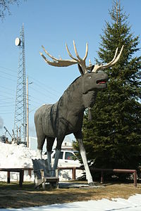 Picture of Max the Moose in Dryden
Dryden is known by people passing by as the home of "Max the Moose", Dryden's 5.6 metres (18 ft) high mascot on the Trans-Canada Highway. The city holds an annual Moosefest festival, during which musical performances, children's activities and a fishing tournament known as The Walleye Masters are held.
Several annual music concerts are held featuring local musicians. "Come Together" is an annual Christmas concert, and "Kickin' Country" is a country show featuring local acts. The "Blue Moon Festival" is a daylong event that is held on or near a blue moon calendar event in the summer months.
Dryden is home to a variety of arts groups. "Theatre 17" is a community theatre group that stages theatrical productions, including Noises Off and Tony and Tina's Wedding. The DRAC (Dryden Regional Arts Council) is an artists group that organizes yearly art tours, art shows and also operates a retail store known as Naked North Art Gallery. The Dryden Community Band is a group of musicians who perform under conductor Ryan Graham.
Media
Radio
- FM 92.7 - CKDR, adult contemporary
- FM 97.3 - CJIV, Christian
- FM 98.5 - CFCD, tourist information
- FM 100.9 - CBQH, CBC Radio One
- FM 102.7 - CKSB-6, Première Chaîne
- FM 104.5 - CKQV, hot adult contemporary
Television
- CBWFT-9 Channel 6 (Radio-Canada)
- CBWDT Channel 9 (CBC)
Print
Dryden has one community newspaper, The Dryden Observer and is also serviced by the Thunder Bay Chronicle-Journal, which operates a bureau in Dryden.
Notable natives
Dryden is the birthplace of NHL hockey player Chris Pronger.
Education
Dryden is home to Dryden High School. A secondary school which is part of the Keewatin-Patricia District School Board.
References
- ^ a b "Dryden community profile". 2006 Census data. Statistics Canada. http://www12.statcan.ca/english/census06/data/profiles/community/Details/Page.cfm?Lang=E&Geo1=CSD&Code1=3560027&Geo2=PR&Code2=35&Data=Count&SearchText=dryden&SearchType=Begins&SearchPR=01&B1=All&Custom=. Retrieved 2011-05-20.
- ^ a b Environment Canada — Canadian Climate Normals 1971–2000, accessed 6 November 2009
- ^ Statistics Canada Population and Dwelling counts, census subdivisions (municipalities), 2006 and 2001 censuses, sorted by province, then sorted by type. Dryden has the smallest population for any city (CY). Retrieved 5 September 2007.
- ^ Gerrie Noble (2001-02-16). "History of Dryden : A Chronology of Events at Dryden (from 1875 to 1945)". Dryden District Chamber of Commerce. Archived from the original on 2007-06-08. http://web.archive.org/web/20070608152256/http://www.cityofdryden.on.ca/history.shtml. Retrieved 2007-09-27.
- ^ Mercury Rising: The Poisoning of Grassy Narrows, CBC TV, November 1st, 1970. Accessed 2007-07-26.
- ^ "2006 Community Profiles". Statistics Canada. Government of Canada. 2009-02-24. http://www12.statcan.ca/census-recensement/2006/dp-pd/prof/92-591/index.cfm?Lang=E. Retrieved 2011-05-20.
- ^ "2001 Community Profiles". Statistics Canada. Government of Canada. 2007-02-01. http://www12.statcan.ca/english/profil01/CP01/Index.cfm?Lang=E. Retrieved 2011-05-20.
External links
Cities Dryden • Kenora
Towns Townships Indian reserves Attawapiskat 91A • Bearskin Lake • Cat Lake 63C • Deer Lake • Eagle Lake 27 • English River 21 • Fort Albany 67 (part) • Fort Hope 64 • Fort Severn 89 • Kasabonika Lake • Keewaywin • Kenora 38B • Kingfisher Lake 1 • Kitchenuhmaykoosib Aaki 84 • Lac Seul 28 • Lake of the Woods 31G • Lake of the Woods 37 • Marten Falls 65 • Muskrat Dam Lake • Neskantaga • North Spirit Lake • Northwest Angle 33B • Osnaburgh 63B • Pikangikum 14 • Poplar Hill • Rat Portage 38A • Sabaskong Bay 35C and 35D • Sachigo Lake 1 and 2 • Sandy Lake 88 • Shoal Lake 39A (part) • Shoal Lake 40 (part) • Shoal Lake 34B2 • The Dalles 38C • Wabaseemoong • Wabauskang 21 • Wabigoon Lake 27 • Wapekeka 1 and 2 • Wawakapewin • Weagamow Lake 87 • Whitefish Bay 32A • Whitefish Bay 33A • Whitefish Bay 34A • Wunnumin 1 and 2Indian settlements Unorganized areas Categories:


Wikimedia Foundation. 2010.