- Neebing, Ontario
-
Neebing — Township — Municipality of Neebing 
 Neebing
Coordinates: 48°11′N 89°28′W / 48.183°N 89.467°WCoordinates: 48°11′N 89°28′W / 48.183°N 89.467°W Country  Canada
Province  Ontario
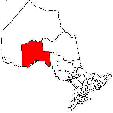
District Thunder Bay Settled Incorporated 1881 Government – Mayor Zygmunt Polkowski – Federal riding Thunder Bay—Rainy River – Prov. riding Thunder Bay—Atikokan Area[1] – Land 875.51 km2 (338 sq mi) Population (2006)[1] – Total 2,184 – Density 2.5/km2 (6.5/sq mi) Time zone EST (UTC-5) – Summer (DST) EDT (UTC-4) Postal Code FSA P7L Area code(s) 807 Website www.neebing.net Neebing is a municipality in the Canadian province of Ontario, located in the Thunder Bay District immediately south of the city of Thunder Bay. It is part of Thunder Bay's Census Metropolitan Area.
Contents
History
Neebing comprises the former geographic townships of Blake, Crooks, Pardee, Pearson and Scoble. It was incorporated in its current form on January 1, 1999. It should not be confused with the geographic township of Neebing, which was amalgamated into the City of Thunder Bay in 1970.
The Municipality of Neebing was incorporated in 1881 by the Legislative Assembly of Ontario. It included Neebing township, Neebing Additional township, Blake, Crooks and Pardee townships. In 1892 all of Neebing Additional township and a large portion of Neebing township was removed to form the City of Fort William. In 1970 the remainder of Neebing township was also removed from the Municipality of Neebing, leaving it with only the name.
Communities
The municipality includes the communities of Cloud Bay, Jarvis River, Moose Hill, Scoble West and Wamsley.
Demographics
Canada census – Neebing, Ontario Community Profile 2006 2001 Population:
Land area:
Population density:
Median age:
Total private dwellings:
Mean household income:2184 (6.6% from 2001)
875.51 km2 (338.04 sq mi)
2.5 /km2 (6.5 /sq mi)
43.1 (males: 43.7, females: 42.1)
1151
$70,1392049 (-2.5% from 1996)
873.24 km2 (337.16 sq mi)
2.3 /km2 (6.0 /sq mi)
39.0 (males: 40.0, females: 38.2)
1088
$61,783Population trend:[4]
- Population in 2006: 2184
- Population in 2001: 2049
- Population in 1996: 1021 (or 2102 when adjusted to 2001 boundaries)
- Land area: 641.03 square kilometres (247.50 sq mi)
- Population in 1991: 889
References
- ^ a b "Neebing community profile". 2006 Census data. Statistics Canada. http://www12.statcan.gc.ca/census-recensement/2006/dp-pd/prof/92-591/details/page.cfm?Lang=E&Geo1=CSD&Code1=3558001&Geo2=PR&Code2=35&Data=Count&SearchText=Neebing&SearchType=Begins&SearchPR=01&B1=All&Custom=. Retrieved 2011-04-28.
- ^ "2006 Community Profiles". Statistics Canada. Government of Canada. 2009-02-24. http://www12.statcan.ca/census-recensement/2006/dp-pd/prof/92-591/index.cfm?Lang=E. Retrieved 2011-04-28.
- ^ "2001 Community Profiles". Statistics Canada. Government of Canada. 2007-02-01. http://www12.statcan.ca/english/profil01/CP01/Index.cfm?Lang=E. Retrieved 2011-04-28.
- ^ Statistics Canada: 1996, 2001, 2006 census

O'Connor Oliver Paipoonge, Thunder Bay Fort William 52 Gillies
Unorg. Thunder Bay District
Lake Superior  Neebing

Grand Portage (U.S.A.) Cities 
Towns Townships Conmee • Dorion • Gillies • Manitouwadge • Neebing • Nipigon • O'Connor • Oliver Paipoonge • Red Rock • Schreiber • Shuniah • Terrace BayFirst Nations Aroland • Biinjitiwabik Zaaging Anishnabek (Rocky Bay) • Bingwi Neyaashi Anishinaabek (Sand Point) • Fort William • Ginoogaming • Kiashke Zaaging Anishinaabek (Gull Bay) • Lac Des Mille Lacs • Long Lake 58 • Namaygoosisagagun • Saugeen (Savant Lake) • Pays Plat • Pic River • Pic Mobert • Red Rock (Lake Helen) • Seine River • WhitesandIndian Reserves Unorganized areas Unorganized Thunder Bay (Local services boards: Armstrong • Hurkett • Kaministiquia • Lappe • Rossport • Shebandowan)Ghost towns See also: Communities in Thunder Bay District • Census divisions of OntarioCategories:- Township municipalities in Ontario
- Municipalities in Thunder Bay District

Wikimedia Foundation. 2010.