- Greenstone, Ontario
-
Greenstone — Town — Municipality of Greenstone Motto: "Spirit of the North" 
Coordinates: 49°45′N 87°17′W / 49.75°N 87.283°WCoordinates: 49°45′N 87°17′W / 49.75°N 87.283°W Country  Canada
Province  Ontario
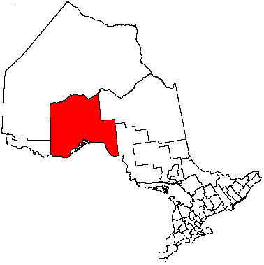
District Thunder Bay Settled Formed 2001 Government - Mayor Renald Beaulieu - Federal riding Thunder Bay—Superior North - Prov. riding Thunder Bay—Superior North Area[1] - Land 2,780.99 km2 (1,073.7 sq mi) Population (2006)[1] - Total 4,906 - Density 1.8/km2 (4.7/sq mi) Time zone EST (UTC-5) - Summer (DST) EDT (UTC-4) Postal code FSA P0T Area code(s) 807 Website www.greenstone.ca Greenstone (Canada 2006 Census population 4,906) is an amalgamated town in the Canadian province of Ontario. The area of the town is 2,780.56 square kilometres (1,073.58 sq mi), stretching along Highway 11 from Lake Nipigon to Longlac; it is one of the largest incorporated towns in Canada.
The town was formed in 2001, as part of a wave of community amalgamations under the Progressive Conservative government of Ontario.[2] It combined the former Townships of Beardmore and Nakina, the Towns of Geraldton and Longlac with large unincorporated portions of Unorganized Thunder Bay District.
Greenstone includes the communities of Nakina, Geraldton, Longlac, Beardmore, Caramat, Jellicoe, Macdiarmid, and Orient Bay. Nakina and Caramat are entirely exclaved from the rest of the municipality's territory.
Contents
History
Nakina was first established in 1923 as a station and railway yard on the National Transcontinental Railway, between the divisional points of Grant and Armstrong. Nakina was at Mile 15.9 of the NTR's Grant Sub-Division. Following the completion in 1924 of Canadian National Railways's Longlac-Nakina Cut-Off, connecting the rails of the Canadian Northern at Longlac and the NTR, Nakina became the new divisional point, and the buildings from the town of Grant (25 kilometers to the east) were moved to the new Nakina town site.
As an important railway service stop from 1923 until 1986, the town had a railway round-house as well as a watering and fueling capability. During World War II, there was also a radar base[3] on the edge of the town, intended to watch for a potential attack on the strategically important Soo Locks at Sault Ste. Marie. Research[citation needed] into the radar site in the National Archives of Canada indicates that it was largely a United States Army Air Forces operation, pre-dating the Pinetree Line radar bases that were erected to focus on the Cold War threat. The Nakina base was totally removed shortly after the war.
The Geraldton-Beardmore Gold Camp, in the heart of the Canadian Shield, hosts numerous mineralized zones which continue to be explored for potential development. Eight gold mines operated here between 1936 and 1970.
In the 1970s pulp and paper operations near the town resulted in growth in the towns population to its peak of approximately 1200. However, at this point cost controls in the railway industry meant that service and maintenance could be consolidated at points much more distant from one another than had been common in the first half of the 20th century. As a result, the value of Nakina as a railway service community was greatly diminished, to the point where it was no longer a substantial employer in the town. Also in the 1970s, a radio station was launched in Longlac as CHAP on the AM dial, which left the air by the late 70s. [4]
As of 2004[update] the town remains focussed on tourism, diminished pulp and paper operations and support of other more northern communities (food, fuel and transportation). Mining and minerals industries are often seen as a source of further growth, though the Canadian Shield geology of the area makes extraction of minerals like gold an expensive operation.
As of 2009[update], a proposed ore transport point around Nakina, as part of the Ring of Fire development, may shift the emphasis of local industry from logging back to mining. In 2010 the Ring of Fire development, proposed James Bay rail link and placement of processing plants remains of great economic interest for the region. Development is slated to move over the next three to five years in an over 1.5 billion dollar project.
On February 19, 2011, Beardmore was temporarily evacuated after a major explosion ruptured the Trans-Canada Pipeline in the community.[5]
Demographics
Canada census – Greenstone, Ontario Community Profile 2006 2001 Population:
Land area:
Population density:
Median age:
Total private dwellings:
Mean household income:4906 (-16.9% from 2001)
2,780.99 km2 (1,073.75 sq mi)
1.8 /km2 (4.7 /sq mi)
39.8 (males: 40.2, females: 39.5)
2596
$64,1535907 (-13.3% from 1996)
2,780.56 km2 (1,073.58 sq mi)
2.0 /km2 (5.2 /sq mi)
36.8 (males: 36.8, females: 36.8)
2702
$52,972References: 2006[6] 2001[7] - Population in 2006: 4906
- Population in 2001: 5907
- Population total in 1996: 6530
- Beardmore (township): 418
- Geraldton (town): 2627
- Longlac (town): 2074
- Nakina (township): 566
- Population in 1991:
- Beardmore (township): 454
- Geraldton (town): 2633
- Longlac (town): 2073
- Nakina (township): 635
Government
Greenstone's mayor is Renald Beaulieu.
The Greenstone Public Library has branches in Beardmore, Geraldton (the Elsie Dugard Centennial Branch), Longlac and Nakina (the Helen Mackie Memorial Branch).
Climate
Climate data for Greenstone Month Jan Feb Mar Apr May Jun Jul Aug Sep Oct Nov Dec Year Record high °C (°F) 5.9
(42.6)16.9
(62.4)16.6
(61.9)25.8
(78.4)32.2
(90.0)37
(99)34.3
(93.7)33.6
(92.5)30.5
(86.9)24.8
(76.6)15.2
(59.4)10.8
(51.4)37
(99)Average high °C (°F) −12.4
(9.7)−8.1
(17.4)−1.5
(29.3)7.2
(45.0)15.6
(60.1)20.9
(69.6)23.4
(74.1)22.2
(72.0)15.3
(59.5)7.5
(45.5)−1.6
(29.1)−9.3
(15.3)6.6 Daily mean °C (°F) −19.2
(−2.6)−15.5
(4.1)−9
(16)0.2
(32.4)8.5
(47.3)14.1
(57.4)16.9
(62.4)15.8
(60.4)9.9
(49.8)3.1
(37.6)−6.1
(21.0)−14.8
(5.4)0.3 Average low °C (°F) −26
(−15)−22.8
(−9.0)−16.6
(2.1)−6.8
(19.8)1.4
(34.5)7.3
(45.1)10.4
(50.7)9.4
(48.9)4.3
(39.7)−1.4
(29.5)−10.6
(12.9)−20.3
(−4.5)−6 Record low °C (°F) −50.2
(−58.4)−49.3
(−56.7)−40.4
(−40.7)−33
(−27)−11.3
(11.7)−4.6
(23.7)1.3
(34.3)0
(32)−7.8
(18.0)−14.8
(5.4)−36.4
(−33.5)−41.7
(−43.1)−50.2
(−58.4)Precipitation mm (inches) 35.7
(1.406)23.9
(0.941)30.5
(1.201)43.6
(1.717)69.1
(2.72)86.1
(3.39)111.7
(4.398)82.9
(3.264)100.4
(3.953)80.6
(3.173)59.4
(2.339)36.4
(1.433)760.4
(29.937)Source: Environment Canada[10] In film
The CBC first nations television series Spirit Bay was shot here in the mid-1980s at the Biinjitiwabik Zaaging Anishnabek First Nations Reserve.
See also
- Beardmore Relics, Viking Age artifacts 'found' near Beardmore, Ontario; originally proposed to be evidence of Vikings in Ontario. Later, the relics were proven to have been a hoax. Through a series of witnesses as well as the son of the person whom had originally found them, the relics were found to have been 'planted' in Beardmore and not, as was suggested, 'found' there.
References
- ^ a b "Greenstone community profile". 2006 Census data. Statistics Canada. http://www12.statcan.gc.ca/census-recensement/2006/dp-pd/prof/92-591/details/page.cfm?Lang=E&Geo1=CSD&Code1=3558075&Geo2=PR&Code2=35&Data=Count&SearchText=Greenstone&SearchType=Begins&SearchPR=01&B1=All&Custom=. Retrieved 2011-04-21.
- ^ Municipal Act RSO 1990 c.M.45
- ^ Dziuban, Stanley W. (1970). Military Relations Between the United States and Canada 1939 - 1945. United States Army Center of Military History. p. 196. CMH Pub 11-5. http://www.ibiblio.org/hyperwar/USA/USA-SS-Canada/USA-SS-Canada-7.html. Retrieved 2010-06-30.
- ^ CHAP AM (1970-1977) - Canadian Communications Foundation.
- ^ "Pipeline blast forces evacuation of northern Ontario town". Toronto Star, February 20, 2011.
- ^ "2006 Community Profiles". Statistics Canada. Government of Canada. 2009-02-24. http://www12.statcan.ca/census-recensement/2006/dp-pd/prof/92-591/index.cfm?Lang=E. Retrieved 2011-04-21.
- ^ "2001 Community Profiles". Statistics Canada. Government of Canada. 2007-02-01. http://www12.statcan.ca/english/profil01/CP01/Index.cfm?Lang=E. Retrieved 2011-04-21.
- ^ Statistics Canada: 1996, 2001, 2006 census
- ^ "Population and dwelling count amendments". 2001 Census data. Statistics Canada. http://www12.statcan.gc.ca/english/census06/data/popdwell/Amend.cfm. Retrieved 2011-04-21.
- ^ Environment Canada—Canadian Climate Normals 1971–2000, accessed 29 April 2010
External links
Cities 
Towns Greenstone • MarathonTownships First Nations Aroland • Biinjitiwabik Zaaging Anishnabek (Rocky Bay) • Bingwi Neyaashi Anishinaabek (Sand Point) • Fort William • Ginoogaming • Kiashke Zaaging Anishinaabek (Gull Bay) • Lac Des Mille Lacs • Long Lake 58 • Namaygoosisagagun • Saugeen (Savant Lake) • Pays Plat • Pic River • Pic Mobert • Red Rock (Lake Helen) • Seine River • WhitesandIndian Reserves Unorganized areas Unorganized Thunder Bay (Local services boards: Armstrong • Hurkett • Kaministiquia • Lappe • Rossport • Shebandowan)Ghost towns See also: Communities in Thunder Bay District • Census divisions of Ontario Categories:- Towns in Ontario
- Municipalities in Thunder Bay District
- Ontario communities with large francophone populations

Wikimedia Foundation. 2010.