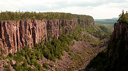
- Dorion, Ontario
-
Dorion — Township — Ouimet Canyon Coordinates: 48°47′N 88°36′W / 48.783°N 88.6°WCoordinates: 48°47′N 88°36′W / 48.783°N 88.6°W Country  Canada
Province  Ontario
District Thunder Bay Settled 1893 Incorporated 1969 Government – Reeve Dave Harris – Federal riding Thunder Bay—Superior North – Prov. riding Thunder Bay—Superior North Area[1] – Land 212.07 km2 (81.9 sq mi) Population (2006)[1] – Total 379 – Density 1.8/km2 (4.7/sq mi) Time zone EST (UTC-5) – Summer (DST) EDT (UTC-4) Postal Code FSA P0T Area code(s) 807 (857 exchange) Website www.doriontownship.ca Dorion is a township in the Canadian province of Ontario, located within the Thunder Bay District. The township had a population of 379 in the Canada 2006 Census. Ouimet Canyon and the Dorion Bible Camp are located in the community.
Demographics
Canada census – Dorion, Ontario Community Profile 2006 2001 Population:
Land area:
Population density:
Median age:
Total private dwellings:
Mean household income:379 (-14.3% from 2001)
212.07 km2 (81.88 sq mi)
1.8 /km2 (4.7 /sq mi)
45.3 (males: 45.3, females: 45.3)
188
$59,195442 (-6.4% from 1996)
212.08 km2 (81.88 sq mi)
2.1 /km2 (5.4 /sq mi)
37.0 (males: 35.9, females: 37.8)
188
$48,141Population trend:[4]
- Population in 2006: 379
- Population in 2001: 442
- Population in 1996: 472
- Population in 1991: 513
References
- ^ a b "Dorion community profile". 2006 Census data. Statistics Canada. http://www12.statcan.gc.ca/census-recensement/2006/dp-pd/prof/92-591/details/page.cfm?Lang=E&Geo1=CSD&Code1=3558034&Geo2=PR&Code2=35&Data=Count&SearchText=dorion&SearchType=Begins&SearchPR=01&B1=All&Custom=. Retrieved 2011-04-25.
- ^ "2006 Community Profiles". Statistics Canada. Government of Canada. 2009-02-24. http://www12.statcan.ca/census-recensement/2006/dp-pd/prof/92-591/index.cfm?Lang=E. Retrieved 2011-04-25.
- ^ "2001 Community Profiles". Statistics Canada. Government of Canada. 2007-02-01. http://www12.statcan.ca/english/profil01/CP01/Index.cfm?Lang=E. Retrieved 2011-04-25.
- ^ Statistics Canada: 1996, 2001, 2006 census

Unorganized Thunder Bay District (Hurkett) 
Unorganized Thunder Bay District 
Black Bay (Lake Superior)  Dorion Twp.

Shuniah Cities 
Towns Townships Conmee • Dorion • Gillies • Manitouwadge • Neebing • Nipigon • O'Connor • Oliver Paipoonge • Red Rock • Schreiber • Shuniah • Terrace BayFirst Nations Aroland • Biinjitiwabik Zaaging Anishnabek (Rocky Bay) • Bingwi Neyaashi Anishinaabek (Sand Point) • Fort William • Ginoogaming • Kiashke Zaaging Anishinaabek (Gull Bay) • Lac Des Mille Lacs • Long Lake 58 • Namaygoosisagagun • Saugeen (Savant Lake) • Pays Plat • Pic River • Pic Mobert • Red Rock (Lake Helen) • Seine River • WhitesandIndian Reserves Unorganized areas Unorganized Thunder Bay (Local services boards: Armstrong • Hurkett • Kaministiquia • Lappe • Rossport • Shebandowan)Ghost towns Categories:- Township municipalities in Ontario
- Municipalities in Thunder Bay District
- Northern Ontario geography stubs
Wikimedia Foundation. 2010.


