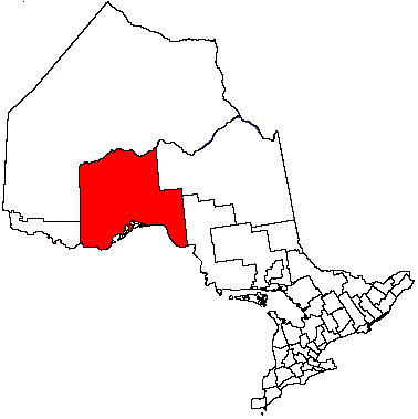
- Unorganized Thunder Bay District
-
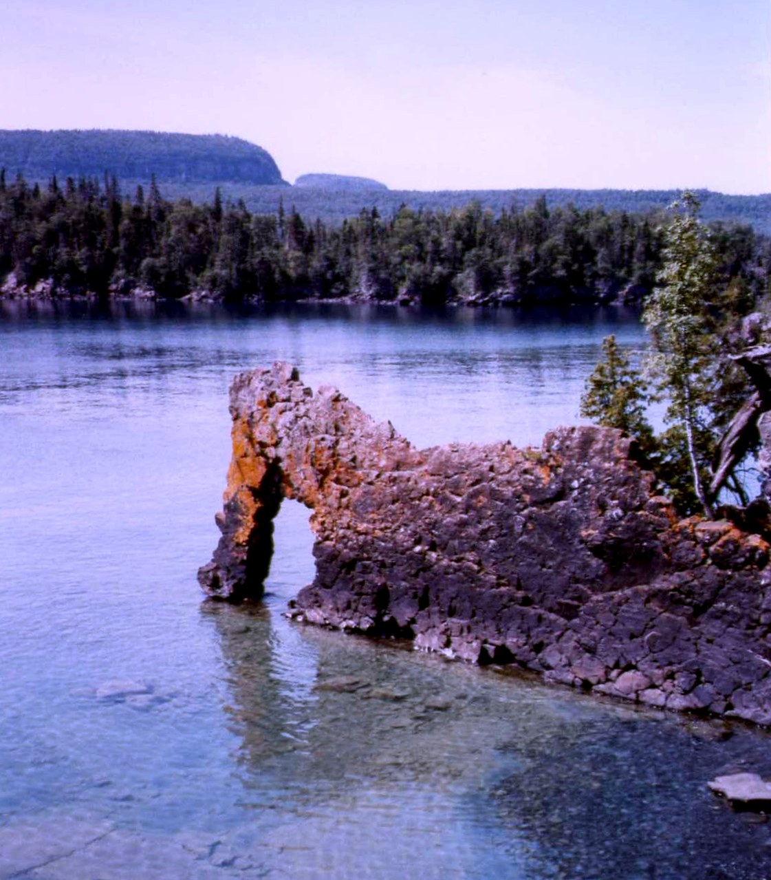
Unorganized Thunder Bay — Unorganized — Sleeping Giant Provincial Park

 Unorganized Thunder Bay
Coordinates: 50°00′N 88°00′W / 50°N 88°WCoordinates: 50°00′N 88°00′W / 50°N 88°W Country  Canada
Province  Ontario
District Thunder Bay Settled Government – Federal riding Algoma—Manitoulin—Kapuskasing
Kenora
Thunder Bay—Rainy River
Thunder Bay—Superior North– Prov. riding Algoma—Manitoulin
Kenora—Rainy River
Thunder Bay—Atikokan
Thunder Bay—Superior NorthArea[1] – Land 97,000.41 km2 (37,452.1 sq mi) Population (2006)[1] – Total 6,585 – Density 0.1/km2 (0.3/sq mi) Time zone EST (UTC-5) – Summer (DST) EDT (UTC-4) Postal Code FSA P0T Area code(s) 807 Unorganized Thunder Bay is an unorganized area in northwestern Ontario, Canada in Thunder Bay District. It comprises all parts of the district that are not part of an incorporated municipality or a First Nations reserve.
Most of the territory is within the Eastern Time Zone, but the part west of the 90th meridian is in the Central Time Zone.
Contents
Local Service Boards
Other communities
Demographics
Canada census – Thunder Bay, Unorganized Community Profile 2006 2001 Population:
Land area:
Population density:
Median age:
Total private dwellings:
Mean household income:6585 (5.8% from 2001)
97,000.41 km2 (37,452.07 sq mi)
0.1 /km2 (0.26 /sq mi)
44.7 (males: 45.2, females: 44.1)
6655
$59,1536223 (-4.8% from 1996)
97,063.48 km2 (37,476.42 sq mi)
0.1 /km2 (0.26 /sq mi)
39.9 (males: 40.9, females: 39.0)
6007
$53,114Population trend:[4]
- Population in 2006: 6585
- Population in 2001: 6223
- Population in 1996: 8460 (or 6534 when adjusted to 2001 boundaries)
- Land area: 105,454.69 square kilometres (40,716.28 sq mi)
- Population in 1991: 8168
Parks in Unorganized Thunder Bay
Provincial parks in Unorganized Thunder Bay include:
- Albany River Provincial Park
- Kopka River Provincial Park
- Neys Provincial Park
- Rainbow Falls Provincial Park
- Sleeping Giant Provincial Park
- Steel River Provincial Park
- Wabakimi Provincial Park
It is also home to one National Park of Canada: Pukaskwa National Park.
References
- ^ a b Bay&SearchType=Begins&SearchPR=01&B1=All&Custom= "Thunder Bay, Unorganized community profile". 2006 Census data. Statistics Canada. http://www12.statcan.gc.ca/census-recensement/2006/dp-pd/prof/92-591/details/page.cfm?Lang=E&Geo1=CSD&Code1=3558090&Geo2=PR&Code2=35&Data=Count&SearchText=Thunder Bay&SearchType=Begins&SearchPR=01&B1=All&Custom=. Retrieved 2011-04-18.
- ^ "2006 Community Profiles". Statistics Canada. Government of Canada. 2009-02-24. http://www12.statcan.ca/census-recensement/2006/dp-pd/prof/92-591/index.cfm?Lang=E. Retrieved 2011-04-18.
- ^ "2001 Community Profiles". Statistics Canada. Government of Canada. 2007-02-01. http://www12.statcan.ca/english/profil01/CP01/Index.cfm?Lang=E. Retrieved 2011-04-18.
- ^ Statistics Canada: 1996, 2001, 2006 census
North: Osnaburgh 63A, Kenora, Unorganized West: Kenora, Unorganized, Rainy River, Unorganized Thunder Bay Unorganized
Thunder Bay, Unorganized surrounds Ojibway Nation of Saugeen (Savant Lake), Whitesand, Gull River 55, Aroland 83, Manitouwadge, Pic Mobert North, Pic Mobert South, Pic River 50, Pays Plat 51, Seine River 22A2, Lac des Mille Lacs 22A1East: Greenstone, Cochrane, Unorganized, North Part, Algoma, Unorganized, North Part, White River, Ginoogaming First Nation, South: Neebing, Gillies, Nolalu, O'Connor, Conmee, Oliver Paipoonge, Thunder Bay, Shuniah, Dorion, Nipigon, Red Rock, Schreiber, Terrace Bay, Marathon Cities 
Towns Townships First Nations Aroland • Biinjitiwabik Zaaging Anishnabek (Rocky Bay) • Bingwi Neyaashi Anishinaabek (Sand Point) • Fort William • Ginoogaming • Kiashke Zaaging Anishinaabek (Gull Bay) • Lac Des Mille Lacs • Long Lake 58 • Namaygoosisagagun • Saugeen (Savant Lake) • Pays Plat • Pic River • Pic Mobert • Red Rock (Lake Helen) • Seine River • WhitesandIndian Reserves Unorganized areas Ghost towns See also: Communities in Thunder Bay District • Census divisions of OntarioCategories:- Thunder Bay District
- Unorganized areas in Ontario
- Northern Ontario geography stubs

Wikimedia Foundation. 2010.