- Manitouwadge, Ontario
-
Manitouwadge — Township — 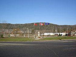

 Manitouwadge
Coordinates: 49°08′N 85°50′W / 49.133°N 85.833°WCoordinates: 49°08′N 85°50′W / 49.133°N 85.833°W Country  Canada
Province  Ontario
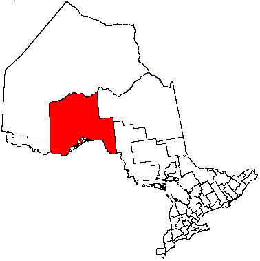
District Thunder Bay Settled 1950s Incorporated 1975 Government – Mayor John MacEachern – Federal riding Algoma—Manitoulin—Kapuskasing – Prov. riding Algoma—Manitoulin Area[1] – Land 351.97 km2 (135.9 sq mi) Population (2006)[1] – Total 2,300 – Density 6.5/km2 (16.8/sq mi) Time zone EST (UTC-5) – Summer (DST) EDT (UTC-4) Postal Code P0T 2C0 Area code(s) 807 (826 exchange) Website www.manitouwadge.ca Manitouwadge is a township in the Canadian province of Ontario. It is located in the Thunder Bay District, at the north end of Highway 614, 331 kilometres (206 mi) east of Thunder Bay and 378 kilometres (235 mi) west of Sault Ste. Marie.
Contents
History
Manitouwadge (Manidoowaazh in Ojibwe, meaning “Cave of the Great Spirit”) was originally part of the range of the nomadic Ojibwe indigenous people. The town itself was founded by Noranda (now part of Xstrata) in the early 1950s to support the company's Geco copper mine. Other mine in Manitouwadge is the Willroy mine, named after two of the "Weekend Prospectors" William Dawidowich and Roy Barker.
From 1954 to 1974 Manitouwadge was classified as an Improvement District. The community became an incorporated township in 1975.
In the early 1980s, gold was discovered at Hemlo, near the intersection of highways 614 and 17, about 50 kilometres (31 mi) south of the town. Noranda acquired the mining rights to a significant portion of the ground in that area, and built the Golden Giant Mine. It offered housing in Manitouwadge to many of the employees of the new mine, and the town boomed.
When the Geco mine closed in 1995, Manitouwadge's population decreased significantly. After peaking at nearly 4000 people in the early 1990s, it decreased to less than 3000 by 2001. With the closing of the Golden Giant Mine in 2006, the population dropped to 2,300.[1]
Today
While mining has always been at the forefront of Manitouwadge's economic activity, forestry also plays a significant part in the town's economy. The town is also turning itself into a retirement community, offering some of the lowest housing prices in the country.
Demographics
Canada census – Manitouwadge, Ontario Community Profile 2006 2001 Population:
Land area:
Population density:
Median age:
Total private dwellings:
Mean household income:2300 (-22.0% from 2001)
351.97 km2 (135.90 sq mi)
6.5 /km2 (17 /sq mi)
42.8 (males: 43.4, females: 42.2)
1212
$78,8942949 (-13.1% from 1996)
351.97 km2 (135.90 sq mi)
8.4 /km2 (22 /sq mi)
36.6 (males: 38.1, females: 35.0)
1317
$70,921Population trend:[4]
- Population in 2006: 2300
- Population in 2001: 2949
- Population in 1996: 3395
- Population in 1991: 3972
Recreation
Summer is open to many outdoor activities. Hunting, fishing and golf are the main summer attractions open to vacationers and residents. There is a nine hole Golf Course which is one of the only courses in Ontario where you don't need to book a Tee-Off. There is a fully equipped gym, a large outside track, and a family pool. Trails for hiking in the summer and trails for snowmobilers in the winter are also abundant. Nine different runs for downhill skiing are present as well as two locations with cross country ski trails managed by the Northern Trails Ski Club as well. From the top of the ski hill one can see the whole town.
Trivia
- Four Geographic Townships (Mapledoram, Leslie, Gemmel, and Gertrude) exist within the town limits.
- Willroy mine was named after two of the "Weekend Prospectors." William Dawidowich and Roy Barker.
- Manitouwadge was the first Model Town established in Ontario.
- Nearby Mose Lake is named after Moses Fisher, the native guide of James E. Thomson on his 1931 exploration of the Manitouwadge area. Name duplication required the S be dropped.
- From 1954 to 1974 Manitouwadge was classified as an Improvement District. The community attained Township classification in 1975.
- Birthplace of Stanley Cup and Olympic Gold Medal Winning Hockey Coach Mike Babcock
Climate
Climate data for Manitouwadge Month Jan Feb Mar Apr May Jun Jul Aug Sep Oct Nov Dec Year Record high °C (°F) 5
(41)8.9
(48.0)19
(66)28.5
(83.3)35
(95)39
(102)39.4
(102.9)34
(93)30.6
(87.1)25
(77)18.3
(64.9)12.5
(54.5)39.4
(102.9)Average high °C (°F) −11.4
(11.5)−8.3
(17.1)−1.1
(30.0)7.6
(45.7)16.4
(61.5)21.2
(70.2)23.9
(75.0)22.2
(72.0)15.1
(59.2)7.7
(45.9)−0.7
(30.7)−8.5
(16.7)7 Daily mean °C (°F) −17.1
(1.2)−14.5
(5.9)−7.5
(18.5)1.3
(34.3)9.7
(49.5)14.6
(58.3)17.5
(63.5)16.2
(61.2)10.2
(50.4)3.9
(39.0)−4.2
(24.4)−13.4
(7.9)1.4 Average low °C (°F) −22.8
(−9.0)−20.7
(−5.3)−13.9
(7.0)−5
(23)2.9
(37.2)8
(46)11.1
(52.0)10.2
(50.4)5.3
(41.5)0
(32)−7.7
(18.1)−18.2
(−0.8)−4.2 Record low °C (°F) −45
(−49)−42.2
(−44.0)−37.5
(−35.5)−30
(−22)−13.3
(8.1)−2.8
(27.0)−1.1
(30.0)−1.1
(30.0)−6.1
(21.0)−14.5
(5.9)−33.9
(−29.0)−38.9
(−38.0)−45
(−49)Precipitation mm (inches) 64.4
(2.535)43.7
(1.72)48.5
(1.909)44
(1.73)66.4
(2.614)80.8
(3.181)107.4
(4.228)81.9
(3.224)104.1
(4.098)81.3
(3.201)73.5
(2.894)63.2
(2.488)859.2
(33.827)Rainfall mm (inches) 0.2
(0.008)2.1
(0.083)9
(0.35)26.5
(1.043)62.6
(2.465)80.8
(3.181)107.4
(4.228)81.9
(3.224)101.9
(4.012)66.6
(2.622)22.1
(0.87)2.6
(0.102)563.6
(22.189)Snowfall cm (inches) 64.2
(25.28)41.6
(16.38)39.5
(15.55)17.4
(6.85)3.9
(1.54)0
(0)0
(0)0
(0)2.2
(0.87)14.7
(5.79)51.5
(20.28)60.6
(23.86)295.6
(116.38)Source: Environment Canada[5] References
- ^ a b c "Manitouwadge community profile". 2006 Census data. Statistics Canada. http://www12.statcan.gc.ca/census-recensement/2006/dp-pd/prof/92-591/details/page.cfm?Lang=E&Geo1=CSD&Code1=3558066&Geo2=PR&Code2=35&Data=Count&SearchText=Manitouwadge&SearchType=Begins&SearchPR=01&B1=All&Custom=. Retrieved 2011-04-21.
- ^ "2006 Community Profiles". Statistics Canada. Government of Canada. 2009-02-24. http://www12.statcan.ca/census-recensement/2006/dp-pd/prof/92-591/index.cfm?Lang=E. Retrieved 2011-04-21.
- ^ "2001 Community Profiles". Statistics Canada. Government of Canada. 2007-02-01. http://www12.statcan.ca/english/profil01/CP01/Index.cfm?Lang=E. Retrieved 2011-04-21.
- ^ Statistics Canada: 1996, 2001, 2006 census
- ^ Environment Canada — Canadian Climate Normals 1971–2000, accessed 2011-04-21
External links
- Manitouwadge tourism website
- Manitouwadge and area Local DAILY newspaper
- The Echo - Manitouwadge local weekly newspaper
- Education links
Cities 
Towns Townships First Nations Aroland • Biinjitiwabik Zaaging Anishnabek (Rocky Bay) • Bingwi Neyaashi Anishinaabek (Sand Point) • Fort William • Ginoogaming • Kiashke Zaaging Anishinaabek (Gull Bay) • Lac Des Mille Lacs • Long Lake 58 • Namaygoosisagagun • Saugeen (Savant Lake) • Pays Plat • Pic River • Pic Mobert • Red Rock (Lake Helen) • Seine River • WhitesandIndian Reserves Unorganized areas Unorganized Thunder Bay (Local services boards: Armstrong • Hurkett • Kaministiquia • Lappe • Rossport • Shebandowan)Ghost towns See also: Communities in Thunder Bay District • Census divisions of OntarioCategories:- Township municipalities in Ontario
- Municipalities in Thunder Bay District
- Mining communities in Ontario
- Company towns in Canada


Wikimedia Foundation. 2010.