- Minnesota State Highway 55
-
Trunk Highway 55
Route information Maintained by Mn/DOT Length: 220.572 mi[1] (354.976 km) Existed: 1933 – present Major junctions West end:  ND 11 at the Bois de Sioux River
 U.S. 59 , MN 79 at Elbow Lake

 MN 28 , MN 29 at Glenwood

 MN 4 , MN 23 at Paynesville
 MN 25 at Buffalo
 I-494 at Plymouth
 U.S. 169 at Plymouth , Golden Valley
 MN 100 at Golden Valley
 I-94 at Minneapolis

 MN 62 , MN 5 at Fort Snelling
 U.S. 52 at Rosemount
East end:  U.S. 61 in Hastings
Location Counties: Wilkin, Grant, Douglas, Pope, Stearns, Kandiyohi, Meeker, Wright, Hennepin, Dakota Highway system Minnesota Trunk Highways
Interstate • U.S. • State
Inter-County • County roads • Legislative routes←  MN 54
MN 54MN 56  →
→Minnesota State Highway 55 is a highway in west-central, central, and east-central Minnesota, which runs from the North Dakota state line near Tenney and continues east and southeast to its eastern terminus at its intersection with U.S. Highway 61 in Hastings.
This route, signed east–west, runs roughly diagonally across the central part of Minnesota.
Highway 55 is 221 miles (356 km) in length.
Contents
Route description
Highway 55 serves as a northwest–southeast route between Elbow Lake, Glenwood, Paynesville, Annandale, Buffalo, Plymouth, Minneapolis, Mendota Heights, and Hastings.
Highway 55 begins at the Bois de Sioux River, at the Minnesota — North Dakota state line near Tenney. North Dakota Highway 11 is its counterpoint upon crossing the state line. Highway 55 continues east to Tenney, Nashua, and Wendell. The route has a junction with U.S. Highway 59 before entering the city of Elbow Lake. Highways 55 and 59 run concurrently for 11 miles until reaching Barrett.
Highway 55 then continues independently again to Hoffman, Kensington, Farwell, and Lowry before reaching the city of Glenwood. At Glenwood, Highway 55 has an intersection with State Highway 29 and an interchange with State Highway 28.
The route continues southeast to Sedan and Brooten before reaching its junction with U.S. Highway 71 in Belgrade. Highway 55 passes through Regal before reaching its junction with State Highways 4 and 23 at the city of Paynesville.
Highway 55 continues east to Eden Valley and Watkins before reaching its junction with State Highway 15 at Kimball.
The route has a junction with State Highway 24 in Annandale. Highway 55 continues to Maple Lake and then Buffalo, where it has a junction with State Highway 25.
Highway 55 enters the Twin Cities area at Rockford and Greenfield, continuing east to Medina and Plymouth. Highway 55 has a junction with I-494 in Plymouth. Highway 55 continues east and has a junction with U.S. Highway 169 at the Plymouth / Golden Valley boundary line. Highway 55 continues through Golden Valley to its junction with State Highway 100. The route then continues east and enters the city of Minneapolis.
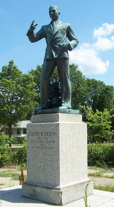
The western portion of the highway coming into downtown Minneapolis is known as Olson Memorial Highway, named for Floyd B. Olson, a popular Minnesota governor of Norwegian ancestry. The part of Highway 55 southeast of downtown is known as Hiawatha Avenue. A light rail corridor, the Hiawatha Line, runs parallel to the highway for much of the Hiawatha Avenue stretch.
 Olson Memorial Highway statue
In July 2005, the section of Highway 55 that runs through downtown Minneapolis was turned back to local maintenance. To fill the gap, Highway 55 was rerouted along Interstate 94. Westbound, 55 now exits just before downtown at the westbound I-94 exit, and leaves the concurrency at the exit for the Olson Highway, marked with the Highway 55 shield. Eastbound, 55 leaves the Olson Highway at the interchange for I-94 eastbound, and leaves the freeway at the exit for Hiawatha Avenue, which is also marked with the Highway 55 shield.
There has been some controversy with expansion of the highway. An area known as Camp Coldwater, considered by some as the "birthplace of Minnesota," was dug up during some construction. Highway 55 has a junction with State Highway 62 at this point.
Fort Snelling State Park is located near the junction of Highway 55 and State Highway 5. The park entrance is located on Highway 5 at Post Road.
Highway 55 crosses the Minnesota River via the Mendota Bridge, which was the longest continuous bridge made of poured concrete when it was completed in 1926. It is 4,119 feet (1,255 m) in length.
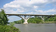 The Mendota Bridge between Fort Snelling and Mendota Heights carries Highway 55 over the Minnesota River
The route enters Mendota Heights and has a junction with State Highways 13 and 110.
Highway 55 continues southeast through Eagan, joining briefly with State Highway 149. The route then has a junction with State Highway 3 in Inver Grove Heights. Highway 55 then runs concurrent with U.S. Highway 52 through Inver Grove Heights and into Rosemount. At Rosemount, Highway 55 leaves U.S. 52. Highway 55 continues independently again to its eastern terminus at its intersection with U.S. Highway 61 in the city of Hastings.
History
Highway 55 was authorized in 1933.[2]
In late December 2006, someone added a 7-foot (2.1 m) painting of Pac-Man near one of the anti-tailgating dots on the road. This is located on the portion of Highway 55 between Buffalo and Rockford, traveling east of Buffalo.[1]
Major intersections
County Location Mile[3][4][5][1] Destinations Notes Bois de Sioux River 0.000 ND 11Wilkin Campbell Township 3.503  US 75
US 75Champion Township 10.706  MN 9
MN 9Grant Pomme de Terre Township 27.841 US 59North end of US 59 overlap Elbow Lake 31.218 MN 7931.880 MN 54Barrett 38.826 US 59South end of US 59 overlap Hoffman 45.704  MN 27
MN 27Pope Ben Wade Township 61.151  MN 114
West end of MN 114 overlap Lowry 61.814 MN 114East end of MN 114 overlap Reno Township 68.816 MN 29Glenwood 70.824-71.070 MN 28Interchange Stearns Belgrade 93.667  US 71
US 71West end of US 71 overlap Crow River Township 94.649 US 71East end of US 71 overlap Kandiyohi Roseville Township 106.064 MN 4West end of MN 4 overlap Stearns Paynesville 108.569 MN 23Meeker Union Grove Township 113.517 MN 4East end of MN 4 overlap Eden Valley 119.491  MN 22
MN 22Stearns Kimball 131.973 
 MN 15 / MN 24
West end of MN 24 overlap Wright Annandale 141.631 MN 24East end of MN 24 overlap Buffalo 155.200 MN 25 (Central Avenue)Hennepin Plymouth 180.435-180.592 I-494Interchange Plymouth / Golden Valley 183.813-184.247 US 169Interchange Golden Valley 186.487-186.746 MN 100Interchange Minneapolis 189.651 I-94West end of I-94 overlap 191.914 I-94East end of I-94 overlap 192.248-192.574  CR 152 (Cedar Avenue)
Interchange 193.163-193.464  CR 3 (Lake Street)
Interchange Fort Snelling 197.142-197.233 MN 62Interchange 197.800-198.217 MN 5Interchange Minnesota River 198.227 Mendota Bridge Dakota Mendota Heights 199.151  MN 110
199.935  MN 13
MN 13Eagan 202.163-202.171  MN 149
North end of MN 149 overlap 202.705 MN 149South end of MN 149 overlap Inver Grove Heights 204.557-204.974  MN 3 (South Robert Trail)
Interchange 205.929-205.930 CR 73 (Barnes Avenue) Interchange 206.515 US 52North end of US 52 overlap US 52: 120.705-120.943  CR 56 (Concord Boulevard)
Interchange, old MN 56 Inver Grove Heights / Rosemount US 52: 118.059-118.565 117th Street Interchange Rosemount 210.836 US 52South end of US 52 overlap Hastings 220.306-220.313 US 611.000 mi = 1.609 km; 1.000 km = 0.621 mi
Concurrency terminus • Closed/Former • Incomplete access • UnopenedReferences
- ^ a b "Trunk Highway Log Point Listing - Construction District 5" (PDF). Minnesota Department of Transportation. August 20, 2010. http://www.dot.state.mn.us/roadway/data/reports/logpoint/metrolpt.pdf. Retrieved October 23, 2010.
- ^ Riner, Steve. "Details of routes 51-75". The Unofficial Minnesota Highways Page. http://www.steve-riner.com/mnhighways/r51-75.htm#55. Retrieved October 23, 2010.[unreliable source]
- ^ "Trunk Highway Log Point Listing - Construction District 4" (PDF). Minnesota Department of Transportation. August 23, 2010. http://www.dot.state.mn.us/roadway/data/reports/logpoint/d4.pdf. Retrieved October 23, 2010.
- ^ "Trunk Highway Log Point Listing - Construction District 3" (PDF). Minnesota Department of Transportation. August 23, 2010. http://www.dot.state.mn.us/roadway/data/reports/logpoint/d3.pdf. Retrieved October 23, 2010.
- ^ "Trunk Highway Log Point Listing - Construction District 8" (PDF). Minnesota Department of Transportation. August 23, 2010. http://www.dot.state.mn.us/roadway/data/reports/logpoint/d8.pdf. Retrieved October 23, 2010.
Categories:- State highways in Minnesota


Wikimedia Foundation. 2010.