- Oakport Township, Clay County, Minnesota
-
Oakport Township, Minnesota — Township — Location within the state of Minnesota
 Oakport Township, Minnesota
Coordinates: 46°56′34″N 96°45′8″W / 46.94278°N 96.75222°WCoordinates: 46°56′34″N 96°45′8″W / 46.94278°N 96.75222°W Country United States State Minnesota County Clay Area – Total 29.2 sq mi (75.6 km2) – Land 29.2 sq mi (75.6 km2) – Water 0.0 sq mi (0.0 km2) Elevation 899 ft (274 m) Population (2000) – Total 1,689 – Density 57.9/sq mi (22.4/km2) Time zone Central (CST) (UTC-6) – Summer (DST) CDT (UTC-5) FIPS code 27-47932[1] GNIS feature ID 0665193[2] Oakport Township is a township in Clay County, Minnesota, United States. The population was 1,689 at the 2000 census. Oakport Township has reached an orderly annexation agreement to enter the city of Moorhead in 2015.
Some parts of Oakport are relatively low, and some properties have endured flooding from the Red River of the North. After a major flood in 1997, efforts were undertaken to mitigate flood damage in Oakport Township, resulting the removal of many houses in flood prone areas. Construction of a dike to protect Oakport is in the planning stages.
Oakport residents enjoy a country lifestyle just outside of city boundaries. In recent years, new housing developments have appeared in Oakport Township.
According to local historians, Oakport Township received its name because it was a stop for steam boats plying the Red River of the North between Moorhead and Winnipeg, Manitoba. Steamboat captains would stop to take on oak wood offered by a local farmer who lived in what is now Oakport Township. The stop became known as the oak port.
Geography
According to the United States Census Bureau, the township has a total area of 29.2 square miles (75.5 km²), all of it land.
Demographics
As of the census[1] of 2000, there were 1,689 people, 572 households, and 498 families residing in the township. The population density was 57.9 people per square mile (22.4/km²). There were 589 housing units at an average density of 20.2/sq mi (7.8/km²). The racial makeup of the township was 97.99% White, 0.36% African American, 0.36% Native American, 0.06% Asian, 0.12% from other races, and 1.12% from two or more races. Hispanic or Latino of any race were 0.71% of the population.
There were 572 households out of which 43.4% had children under the age of 18 living with them, 80.4% were married couples living together, 4.4% had a female householder with no husband present, and 12.9% were non-families. 11.5% of all households were made up of individuals and 4.4% had someone living alone who was 65 years of age or older. The average household size was 2.93 and the average family size was 3.13.
In the township the population was spread out with 30.0% under the age of 18, 5.9% from 18 to 24, 30.4% from 25 to 44, 24.7% from 45 to 64, and 9.1% who were 65 years of age or older. The median age was 38 years. For every 100 females there were 107.2 males. For every 100 females age 18 and over, there were 102.6 males.
The median income for a household in the township was $60,400, and the median income for a family was $62,794. Males had a median income of $41,856 versus $26,842 for females. The per capita income for the township was $21,570. About 2.8% of families and 4.5% of the population were below the poverty line, including 4.9% of those under age 18 and 7.0% of those age 65 or over.
References
- ^ a b "American FactFinder". United States Census Bureau. http://factfinder.census.gov. Retrieved 2008-01-31.
- ^ "US Board on Geographic Names". United States Geological Survey. 2007-10-25. http://geonames.usgs.gov. Retrieved 2008-01-31.
Municipalities and communities of Clay County, Minnesota Cities 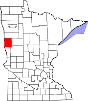
Townships Alliance | Barnesville | Cromwell | Eglon | Elkton | Elmwood | Felton | Flowing | Georgetown | Glyndon | Goose Prairie | Hagen | Hawley | Highland Grove | Holy Cross | Humboldt | Keene | Kragnes | Kurtz | Moland | Moorhead | Morken | Oakport | Parke | Riverton | Skree | Spring Prairie | Tansem | Ulen | Viding
CDP Unincorporated
communitiesGhost towns Categories:- Townships in Clay County, Minnesota


Wikimedia Foundation. 2010.