- U.S. Route 12 in Minnesota
-
This article is about the section of U.S. Route 12 in Minnesota. For the entire length of the highway, see U.S. Route 12.
U.S. Highway 12
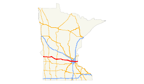
Highway 12 highlighted in red.Route information Maintained by MnDOT Length: 192.798 mi[2] (310.278 km) Existed: November 11, 1926[1] – present Major junctions West end:  U.S. 12 at the Minnesota — South Dakota state line
 U.S. 75 / MN 7 at Ortonville

 MN 9 / MN 29 at Benson

 U.S. 71 / MN 23 at Willmar

 MN 22 / MN 24 at Litchfield
 MN 15 at Dassel
 MN 25 at Montrose

 I-394 / I-494 at Minnetonka

 I-94 / I-35W at Minneapolis
 I-494 / I-694 at Woodbury
 MN 95 at Lakeland
East end: I-94/U.S. 12 at the St. Croix River,
the Minnesota — Wisconsin state lineLocation Counties: Big Stone, Swift, Kandiyohi, Meeker, Wright, Hennepin, Ramsey, Washington Highway system United States Numbered Highways
List • Bannered • Divided • ReplacedMinnesota Trunk Highways
Interstate • U.S. • State
Inter-County • County roads • Legislative routes←  MN 11
MN 11MN 13  →
→U.S. Route 12 is a highway in west-central and east-central Minnesota, which runs from the South Dakota state line at Ortonville near Big Stone Lake and continues east to the St. Croix River at the Wisconsin state line. U.S. 12 in Minnesota is 192 miles (309 km) in length. The route connects the cities of Ortonville, Benson, Willmar, Litchfield, Minneapolis, and Saint Paul.
Contents
Route description
From the South Dakota / Minnesota state line at Ortonville, to Orono in the Twin Cities area, U.S. 12 is mostly a rural two-lane highway with a 55 MPH posted speed limit, with slower speed limits through towns and a four-lane surface arterial segment through the city of Willmar.
From Orono to Wayzata, U.S. 12 is a two-lane freeway/super-2 bypass around Long Lake.
From western Wayzata to Interstate 394 in Minnetonka, U.S. 12 is a six-lane freeway. East of Interstate 494, U.S. 12 is invisibly concurrent with Interstates 394 and 94 through Minneapolis and Saint Paul to the Minnesota / Wisconsin state line at Hudson.
U.S. 12 is invisibly concurrent with Interstate 94 in Ramsey and Washington counties.
Legally, the Minnesota section of U.S. 12 is defined as unmarked Constitutional / Legislative Routes 149, 26, and 10 in Minnesota Statutes §§ 161.115(80) and 161.114(2). U.S. 12 is not marked with these legislative numbers along the actual highway.
History
U.S. Highway 12 was established on November 11, 1926.[1]
In 1929, the only sections paved were between Litchfield and Willmar; and between Wayzata through the Twin Cities to Wisconsin.[3]
The entire route was paved by 1940.[3]
From 2006 to 2008, the Highway 12 two-lane freeway bypass was constructed through Orono and Long Lake. The new bypass ties into the existing Highway 12 freeway at the western edge of Wayzata.
Major intersections
County Location Mile[2][4][5][6] Destinations Notes South Dakota-Minnesota state line 0.000 US 12Big Stone Ortonville 0.821 MN 7North end of MN 7 concurrency 0.950 MN 7South end of MN 7 concurrency 1.350 US 75Swift Shible Township 21.097  MN 119
Moyer Township 27.088  US 59
US 59Benson 42.633 MN 29South end of MN 29 concurrency 42.860 MN 29
MN 9North end of MN 29 concurrency
West end of MN 9 concurrency42.930 MN 9East end of MN 9 concurrency Kandiyohi Willmar 72.618  MN 40
MN 40Kandiyohi Township 75.696-75.793 US 71 / MN 23Meeker Grove City 91.650  MN 4
MN 4West end of MN 4 concurrency Swede Grove Township 92.261 MN 4East end of MN 4 concurrency Litchfield Township 98.757 MN 22North end of MN 22 concurrency 99.945 MN 24Litchfield 100.777 MN 22South end of MN 22 concurrency Dassel Township 111.360 MN 15Wright Montrose 132.095 MN 25West end of MN 25 concurrency Rockford Township 134.152 MN 25East end of MN 25 concurrency Hennepin Wayzata 180.158  CR 101
(old MN 101)
Minnetonka 157.014 I-494, I-394West end of I-394 concurrency, exit 1A Minneapolis 165.654 I-94East end of I-394 concurrency,
West end of I-94 concurrencyUnmarked concurrency with I-94 to Wisconsin state line St. Croix River 192.997 Interstate Bridge, I-94 / US 12 at the Minnesota-Wisconsin state line1.000 mi = 1.609 km; 1.000 km = 0.621 mi
Concurrency terminus • Closed/Former • Incomplete access • UnopenedReferences
- ^ a b Weingroff, Richard F. (January 9, 2009). "From Names to Numbers: The Origins of the U.S. Numbered Highway System". Federal Highway Administration. http://wwwcf.fhwa.dot.gov/infrastructure/numbers.cfm. Retrieved September 25, 2010.
- ^ a b "Trunk Highway Log Point Listing - Construction District 5" (PDF). Minnesota Department of Transportation. August 20, 2010. http://www.dot.state.mn.us/roadway/data/reports/logpoint/metrolpt.pdf. Retrieved September 27, 2010.
- ^ a b Riner, Steve. "Details of routes 1-25". The Unofficial Minnesota Highways Page. http://www.steve-riner.com/mnhighways/r1-25.htm#12. Retrieved September 27, 2010.[unreliable source]
- ^ "Trunk Highway Log Point Listing - Construction District 4" (PDF). Minnesota Department of Transportation. August 23, 2010. http://www.dot.state.mn.us/roadway/data/reports/logpoint/d4.pdf. Retrieved September 27, 2010.
- ^ "Trunk Highway Log Point Listing - Construction District 8" (PDF). Minnesota Department of Transportation. August 23, 2010. http://www.dot.state.mn.us/roadway/data/reports/logpoint/d8.pdf. Retrieved September 27, 2010.
- ^ "Trunk Highway Log Point Listing - Construction District 3" (PDF). Minnesota Department of Transportation. August 23, 2010. http://www.dot.state.mn.us/roadway/data/reports/logpoint/d3.pdf. Retrieved September 27, 2010.
U.S. Route 12Previous state:
South DakotaMinnesota Next state:
WisconsinCategories:- U.S. Highways in Minnesota
- U.S. Route 12


Wikimedia Foundation. 2010.