- U.S. Route 63 in Minnesota
-
This article is about the section of U.S. Route 63 in Minnesota. For the entire length of the highway, see U.S. Route 63.
U.S. Highway 63
U.S. 63 highlighted in redRoute information Maintained by Mn/DOT Length: 91.881 mi[1] (147.868 km) Existed: 1934 – present Major junctions South end:  US 63 at the Iowa state line
 I-90 near Stewartville
 US 52 in Rochester
 US 14 in Rochester
 US 61 in Lake City and Red Wing
North end:  US 63 at the Mississippi River
Location Counties: Fillmore, Mower, Olmsted, Wabasha, Goodhue Highway system United States Numbered Highways
List • Bannered • Divided • ReplacedMinnesota Trunk Highways
Interstate • U.S. • State
Inter-County • County roads • Legislative routes←  MN 62
MN 62MN 64  →
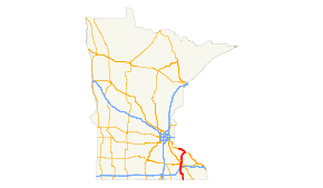
→U.S. Route 63 (US 63) is a highway in southeastern Minnesota that runs from the Minnesota-Iowa border south of Spring Valley to the Mississippi River at Red Wing. It connects the cities of Spring Valley, Stewartville, Rochester, and Lake City.
The route in Minnesota is 92 miles (148 km) in length.
Contents
Route description
U.S. 63 enters the state in Fillmore County, just north of Chester, Iowa. It travels north to Spring Valley where it becomes concurrent with State Highway 16, following it west for five miles. It continues north to Stewartville, where it becomes a divided highway.
The highway is reduced to two lanes on the north side of Rochester and continues north through Olmsted and Wabasha counties. It meets U.S. Highway 61 at Lake City and overlaps it into the city of Red Wing. U.S. 63 turns southeast on State Highway 58 for one block and then turns northeast on 3rd Street. It then curves back northwest to cross over 61, and then reaches the Red Wing Bridge where it crosses the Mississippi River and enters the state of Wisconsin.
Nearly all of the route is legally defined as Constitutional Route 59 in the Minnesota Statutes,[2] except for the part between Red Wing and the Mississippi River, which is Legislative Route 161.[3]
History
U.S. 63 was extended into Minnesota in 1934.[4][5] The route had previously been marked the year before as U.S. 59, except for the segment running from U.S. 61 to the river crossing, which had been State Highway 58.[4] U.S. 63 was an original 1926 U.S. Route and terminated in Des Moines, Iowa until it was extended north. The U.S. 59 designation was simultaneously re-assigned to a new highway running from Laredo, Texas to Pembina, North Dakota.
The route was paved when it was marked.[5]
Major intersections
County Location Mile[1] Destinations Notes Howard Chester US 63 southContinuation into Iowa 0.000 Iowa–Minnesota state line Fillmore Beaver Township 0.503  MN 56
MN 56Spring Valley 13.569  MN 16
MN 16East end of MN 16 overlap Mower Frankford Township 18.601 MN 16West end of MN 16 overlap Olmsted Stewartville 28.714  MN 30 (1st Street E.)
South end of MN 30 overlap High Forest Township 30.702–
30.954 I-90Interchange 31.206 MN 30North end of MN 30 overlap Rochester 35.514 48th Street SW/SE Interchange 36.213 40th Street SW/SE Interchange 37.144–
37.543 US 52Interchange 39.549 US 14 (12th Street SW/SE)Farmington Township 51.225  MN 247
Wabasha Zumbro Falls 59.914  MN 60 (Main Street)
Lake City 74.864 US 61 (Lake Shore Drive)South end of US 61 overlap Goodhue Red Wing 91.136 US 61 (Main Street)
 MN 58 (Plum Street)
North end of US 61 overlap
North end of MN 58 overlap91.208 MN 58South end of MN 58 overlap Mississippi River 91.632 Red Wing Bridge (Minnesota–Wisconsin state line) Pierce Hager City US 63 northContinuation into Wisconsin 1.000 mi = 1.609 km; 1.000 km = 0.621 mi
Concurrency terminus • Closed/Former • Incomplete access • UnopenedReferences
- ^ a b "Trunk Highway Log Point Listing - Construction District 6" (PDF). Minnesota Department of Transportation. August 23, 2010. http://www.dot.state.mn.us/roadway/data/reports/logpoint/d6.pdf. Retrieved February 6, 2011.
- ^ Minnesota State Legislature (2010). "§ 161.114, Constitutional Trunk Highways". Minnesota Statutes. Minnesota Office of the Revisor of Statutes. https://www.revisor.mn.gov/statutes/?id=161.114. Retrieved February 6, 2011.
- ^ "161.115, Additional Trunk Highways". Minnesota Statutes. Office of the Revisor of Statutes, State of Minnesota. 2010. https://www.revisor.mn.gov/statutes/?id=161.115. Retrieved February 6, 2011.
- ^ a b Minnesota Highway Department (May 1, 1934). 1934 Map of Trunk Highway System, State of Minnesota (Map). Section O20-O23. http://reflections.mndigital.org/cdm4/item_viewer.php?CISOROOT=/mdt&CISOPTR=210&DMSCALE=25&DMWIDTH=800&DMHEIGHT=800&DMX=858&DMY=2088&DMMODE=viewer&DMTEXT=&REC=15&DMTHUMB=1&DMROTATE=0. Retrieved February 6, 2010.
- ^ a b Minnesota Highway Department (May 1, 1934). 1935 Map of Trunk Highway System, State of Minnesota (Map). Section O20-O23. http://reflections.mndigital.org/cdm4/item_viewer.php?CISOROOT=/mdt&CISOPTR=211&CISOBOX=1&REC=16. Retrieved February 6, 2010.
External links
U.S. Route 63Previous state:
IowaMinnesota Next state:
WisconsinCategories:- U.S. Highways in Minnesota
- U.S. Route 63


Wikimedia Foundation. 2010.