- Mesquite, Texas
-
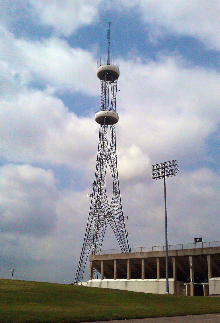
City of Mesquite — City — Mesquite Tower rises over Memorial Stadium in Mesquite.
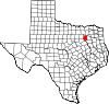
Motto: Real. Texas. Flavor. Location within Dallas County and the state of Texas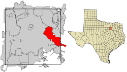
Coordinates: 32°46′58″N 96°36′36″W / 32.78278°N 96.61°WCoordinates: 32°46′58″N 96°36′36″W / 32.78278°N 96.61°W Country  United States
State  Texas
TexasCounties Dallas, Kaufman Government - Type Council-Manager - City Council Mayor John Monaco
Stan Pickett
Dennis Tarpley
Al Forsythe
Shirley Roberts
Bill Porter- City Manager Ted Barron Area - Total 43.5 sq mi (112.6 km2) - Land 43.4 sq mi (112.5 km2) - Water 0.0 sq mi (0.1 km2) Elevation 495 ft (151 m) Population (2010) - Total 139,824 - Density 3,216/sq mi (1,241.7/km2) Time zone CST (UTC-6) - Summer (DST) CDT (UTC-5) ZIP codes 75149, 75150, 75180, 75181, 75185, 75187 Area code(s) 214, 469, 972 FIPS code 48-47892[1] GNIS feature ID 1341400[2] Website http://www.cityofmesquite.com/ Mesquite is a city located within the Dallas/Ft.Worth area of Texas. As of the 2010 US Census, the population was 139,824.
Contents
History
The city was founded May 22, 1873, by a Texas & Pacific Railway engineer who purchased land along the Texas & Pacific line outside of Dallas. The railroad, which ran from Dallas to Shreveport, began stopping at the newly-created town shortly thereafter, and the city began to grow around the railroad. The city was officially incorporated on December 3, 1887.
Mesquite prospered through the late 19th century and early 20th century as a farming community growing cotton, hay, corn and sugar and using the railroad to ship raw goods. The town remained predominantly agrarian until after World War II when the suburban boom also took root in Mesquite. The city's population rapidly grew from 1,696 in the 1950 census to 27,526 in 1960 and 55,131 in 1970.
In 1958, the Mesquite Championship Rodeo was established, and in 1959, Big Town Mall opened as the first enclosed shopping mall in the Southwest. The mall was demolished in the summer of 2006.
By 1970, LBJ Freeway (I-635) was constructed, connecting Mesquite to its neighbors, Garland to the north and Balch Springs to the south. Also in 1971, Town East Mall was constructed. The mall was used by director Ron Howard to film portions of the movie "Cotton Candy" in 1978. The mall's associated traffic and shops would continue to grow the town. By the 1990 census, the city had grown to 101,484 people, nearly twice the population twenty years earlier.
In 1986, the Mesquite Arena (now named Resistol Arena) opened its doors as the new home for the Mesquite Championship Rodeo. By 1998, the facility was expanded to include a Convention Center, Exhibition Hall and a Hampton Inn & Suites.
Geography
Mesquite is located at 32°46′58″N 96°36′36″W / 32.782878°N 96.609862°W (32.782878, -96.609862).[3]
According to the United States Census Bureau, the city has a total area of 43.5 square miles (112.6 km2), of which 43.4 square miles (112.5 km2) of is land and 0.1 square miles (0.1 km2) (0.12%) is water.Mesquite, Texas Climate chart (explanation) J F M A M J J A S O N D 1.955362.361413.169493.577565.384653.992732.496772.296762.789694.779582.666472.55739Average max. and min. temperatures in °F Precipitation totals in inches Source: Weather.com / NWS Metric conversion J F M A M J J A S O N D 4813259165802198825131352918100332362362555362467322111826146619864144Average max. and min. temperatures in °C Precipitation totals in mm Climate
- On average, the warmest month is July.
- The highest recorded temperature was 112°F in 1980.
- The average coolest month is January.
- The lowest recorded temperature was 1°F in 1989.
- May is the average wettest month.
Mesquite is considered to be part of the humid subtropical region.
Government
Local Government
The City Council consists of six Council members. Councilmembers serve two-year terms and are responsible for appointing the City Health Officer, Independent Auditor, Municipal Judge, City Manager, City Attorney, City Secretary and members of various Boards and Commissions. The Mayor and six Councilmembers are elected at large; however, four Council positions have residency requirements.
According to the citys most recent Comprehensive Annual Financial Report, the citys various funds had $180.5 million in Revenues, $162.7 million in expenditures, $546.5 million in total assets, $214.6 million in total liabilities, and $108.1 million in cash and investments.[4]
The structure of the management and coordination of city services is:[4]
City Department Director City Manager Ted Baron Deputy City Manager Carol Zolnerowich Assistant City Manager Jerry Dittman Director of Finance Donald W. Simons Fire Chief Mark Kerby Director or Municipal Airport Cynthia Godfrey Police Chief Derek Rohde Director of Parks and Recreation Cliff Keheley Director of Community Development Richard Gertson Director of Human Resources George Mones Director of Public Works Tim Tumulty Director of Information Technology Zak LaJoie Director of Arts Center Mike Templeton Director of Library Services Jeannie Johnson Director of Housing and Community Services Valerie Bradley Director of Marketing & Tourism John Mayner Communications Manager Wayne Larson, APR Director of Economic Development Thomas E. Palmer State representations
The Texas Department of Transportation operates the Dallas District Office in Mesquite.[5]
Education
Public schools
Mesquite Independent School District provides primary and secondary (K-12) education to most areas of Mesquite. A small portion of Mesquite is served by Dallas Independent School District. While another small area in Kaufman County is within the Forney Independent School District, the section has no residents. Mesquite also serves an area of Balch Springs.
Mesquite is home to five public high schools: Mesquite High School, North Mesquite High School, West Mesquite High School, Poteet High School, John Horn High School. In 2001, the Mesquite Skeeters high school football team won the 5A Division I State Championship.
Private schools
Dallas Christian High School is located in Mesquite.
Colleges and universities
Higher education is provided by two institutions. Eastfield College provides undergraduate degrees and continuing education credits as part of the Dallas County Community College District. The Texas A&M University-Commerce Mesquite Metroplex Center provides graduate-level courses and degrees in a variety of fields.
Transportation
Mesquite is served by a publicly owned and -operated airport, Mesquite Metro Airport.[6] The airport includes a 6,000 ft. lighted runway with ILS. General aviation comprises approximately 75% of daily operations while commercial aviation comprises the rest.[7] Mesquite Metro Airport is popular among transient aircraft due to its location near Dallas and favorable fuel prices.[8]
Two other nearby airports, Dallas-Fort Worth International Airport and Dallas Love Field, provide regular commercial passenger service to the region. Love Field is approximately 15 miles from Mesquite; DFW Airport is approximately 30 miles from Mesquite.
Mesquite is not a member of Dallas Area Rapid Transit, so general public transportation is not available in the city. However, the city operates its own paratransit service for elderly and disabled residents.[9]
Union Pacific Railroad operates an intermodal facility for its freight rail service as part of the Skyline Industrial Park.
Highways
Mesquite is also served by three interstate highways, one US Hwy, and one state highway. IH 20, IH 30, IH 635, US Hwy 80, and SH 352 all pass through Mesquite. Belt Line Road also passes through Mesquite and serves as a major road.
Demographics
- Total population: 139,824 (2010 US Census)
- Total households: 43,926
- Total families: 32,900
- Density 2,868.1 people/mi2 (1,107.3/km2)
- Housing density 1,065.2/mi2 (411.2/mi2)
- Racial makeup:
- 73.54% White
- 3.75% Asian
- 13.32% African American
- 0.60% Native American
- 0.05% Pacific Islander
- 6.43% from other races
- 2.31% from two or more races
- 15.66% Hispanic or Latino of any race
- Per capita income: $20,890
- Median household income: $50,424
- Median family income: $56,357
- Median income (males): $37,756
- Median income (females): $29,905
About 5.0% of families and 6.8% of the population were below the poverty line, including 8.8% of those under age 18 and 6.6% of those age 65 or over.
There were 43,926 households out of which 43.1% had children under the age of 18 living with them, 56.4% were married couples living together, 14.0% had a female householder with no husband present, and 25.1% were non-families. 20.6% of all households were made up of individuals and 4.9% had someone living alone who was 65 years of age or older. The average household size was 2.82 and the average family size was 3.27.
In the city the population was spread out with 30.5% under the age of 18, 9.2% from 18 to 24, 33.9% from 25 to 44, 19.3% from 45 to 64, and 7.1% who were 65 years of age or older. The median age was 32 years. For every 100 females there were 93.0 males. For every 100 females age 18 and over, there were 89.2 males.
Economy
According to the City's 2008 Comprehensive Annual Financial Report,[4] the top employers in the city are:
# Employer # of Employees % of Total City Employment 1 United Parcel Service Inc. 3,000 4.22% 2 Dallas Regional Medical Center 1,150 1.62% 3 City of Mesquite 1,054 1.48% 4 Sears 450 0.63% 5 Texas Dept of Transportation - Dallas District 425 0.60% 6 Baker Drywall LTD 400 0.56% 7 Dallas County Community College 400 0.56% 8 Christian Care Center 400 0.56% 9 Integra Color 383 0.54% 10 Pepsi-Cola Metro Bottling Co Inc 325 0.46% Neighborhoods
Neighborhoods include:
- Lawson
- Park View
- Edgemont Park
- Creek Crossing
- Creek Crossing II
- Falcon's Lair
- Falcon's Ridge
- Pecan Creek
- Rollingwood Hills
- Skyline
- Pasadena Gardens
- Original Town
- Melton
- Tealwood
Constructions
- Mesquite Tower, a lattice tower of unusual design.
- Town East Tower is the tallest inhabited building in Mesquite, standing seven stories high.
Notable people
- Joe Bowden - Former professional football player for the Houston Oilers, Tennessee Titans, and Dallas Cowboys.
- John D. Carmack - American game programmer and the co-founder of id Software. [10] Lead programmer of the id computer games Wolfenstein 3D, Doom, Quake, their sequels and the Commander Keen series of games.
- Ray Cunningham - Former professional baseball player for the St. Louis Cardinals.
- Terry Fator - Singer and Ventriloquist, Winner of America's Got Talent in 2007[11]
- Don Gay - eight-time PRCA world champion bullrider.
- Todd Graham - College football coach. Current head coach of the University of Pittsburgh Panthers.
- Jerry Hall - Actress and model, former wife of Mick Jagger and mother of four of his children.
- Taylor Lipsett - Gold Medalist in Sled Hockey at the 2010 Winter Paralympic Games in Vancouver, B.C. He led Team USA in goals, with 5 goals in 5 games, and added 2 assists for a total of 7 points.
- Sean Lowe - Former professional baseball player for the Chicago White Sox, St. Louis Cardinals, Pittsburgh Pirates, Colorado Rockies, and Kansas City Royals.
- Bryan Massey - Actor and writer.
- Taylor Parks - Actress and singer, best known as Little Inez in Hairspray (2007 film)[12]
- Greg Vaughan- actor on General Hospital.
References
- ^ "American FactFinder". United States Census Bureau. http://factfinder.census.gov. Retrieved 2008-01-31.
- ^ "US Board on Geographic Names". United States Geological Survey. 2007-10-25. http://geonames.usgs.gov. Retrieved 2008-01-31.
- ^ "US Gazetteer files: 2010, 2000, and 1990". United States Census Bureau. 2011-02-12. http://www.census.gov/geo/www/gazetteer/gazette.html. Retrieved 2011-04-23.
- ^ a b c City of Mesquite CAFR Retrieved 2009-08-17
- ^ "Dallas District Office." Texas Department of Transportation. Retrieved on January 11, 2010.
- ^ [1] City of Mesquite web site. Access 10 September 2006
- ^ [2] City of Mesquite web site. Accessed 9 September 2006
- ^ [3]AirNav: Mesquite Metro Airport. Accessed 8 September 2006
- ^ [4]City of Mesquite web site. Accessed 9 September 2006
- ^ Biography for John Carmack at the Internet Movie Database
- ^ http://www.cedarcreekpilot.com/features/local_story_186120320.html Cedar Creek Pilot article
- ^ http://www2.scholastic.com/browse/article.jsp?id=3746845
External links
- Official website
- Mesquite from the Handbook of Texas Online
Dallas–Fort Worth–Arlington Counties Major cities Cities and towns
100k-300kCarrollton • Denton • Frisco • Garland • Grand Prairie • Irving • McKinney • Mesquite • Plano • RichardsonCities and towns
25k-99kAllen • Bedford • Cedar Hill • Cleburne • The Colony • Coppell • DeSoto • Duncanville • Euless • Farmers Branch • Flower Mound • Grapevine • Haltom City • Highland Village • Hurst • Keller • Lancaster • Lewisville • Mansfield • North Richland Hills • Rockwall • Rowlett • WylieCities and towns
10k-25kAddison • Balch Springs • Benbrook • Burleson • Colleyville • Corinth • Ennis • Forest Hill • Greenville • Saginaw • Seagoville • Southlake • Terrell • University Park • Watauga • Waxahachie • Weatherford • White SettlementMunicipalities and communities of Dallas County, Texas Cities Balch Springs | Carrollton‡ | Cedar Hill‡ | Cockrell Hill | Combine‡ | Coppell‡ | Dallas‡ | DeSoto | Duncanville | Farmers Branch | Ferris‡ | Garland‡ | Glenn Heights‡ | Grand Prairie‡ | Grapevine‡ | Hutchins | Irving | Lancaster‡ | Lewisville‡ | Mesquite‡ | Ovilla‡ | Richardson‡ | Rowlett‡ | Sachse‡ | Seagoville‡ | University Park | Wilmer | Wylie‡

Towns Unincorporated
communitiesAlpha | Sand Branch
Footnotes ‡This populated place also has portions in an adjacent county or counties
Municipalities and communities of Kaufman County, Texas Cities Combine‡ | Cottonwood | Crandall | Dallas‡ | Forney | Heath‡ | Kaufman | Mesquite‡ | Seagoville‡ | Seven Points‡ | Talty | Terrell
Towns Villages Unincorporated
communitiesAbles Springs | Elmo | Heartland | Poetry
Footnotes ‡This populated place also has portions in an adjacent county or counties
Mayors of cities with populations exceeding 100,000 in Texas - Annise Parker (Houston)
- Julian Castro (San Antonio)
- Mike Rawlings (Dallas)
- Lee Leffingwell (Austin)
- Betsy Price (Fort Worth)
- John Cook (El Paso)
- Robert Cluck (Arlington)
- Joe Adame (Corpus Christi)
- Phil Dyer (Plano)
- Raul Gonzalez Salinas (Laredo)
- Tom Martin (Lubbock)
- Ronald E. Jones (Garland)
- Beth Van Duyne (Irving)
- Debra McCartt (Amarillo)
- Tony Martinez (Brownsville)
- Charles England (Grand Prairie)
- Johnny Isbell (Pasadena)
- John Monaco (Mesquite)
- Richard F. Cortez (McAllen)
- Ron Branson (Carrollton)
- Virginia DuPuy (Waco)
- Bill Whitfield (McKinney)
- Mark Burroughs (Denton)
- Timothy L. Hancock (Killeen)
- Norm Archibald (Abilene)
- Becky Ames (Beaumont)
- Wes Perry (Midland)
- Alan McGraw (Round Rock)
- Dean Ueckert (Lewisville)
- Bill Keffler (Richardson)
- Lanham Lyne (Wichita Falls)
- Larry Melton (Odessa)
 Other states: AL • AK • AZ • AR • CA • CO • CT • DE • FL • GA • HI • ID • IL • IN • IA • KS • KY • LA • ME • MD • MA • MI • MN • MS • MO • MT • NE • NV • NH • NJ • NM • NY • NC • ND • OH • OK • OR • PA • RI • SC • SD • TN • TX • UT • VT • VA • WA • WV • WI • WYCategories:
- Cities in Texas
- Populated places in Dallas County, Texas
- Dallas – Fort Worth Metroplex
- Populated places in Kaufman County, Texas
- Mesquite, Texas


Wikimedia Foundation. 2010.