- Watauga, Texas
Infobox Settlement
official_name = City of Watauga, Texas
other_name =
native_name =
nickname =
settlement_type =City
motto =
imagesize =
image_caption =
flag_size =
image_
seal_size =
image_shield =
shield_size =
image_blank_emblem =
blank_emblem_size =
imagesize =
image_caption =
flag_size =
image_
seal_size =
image_shield =
shield_size =
image_blank_emblem =
blank_emblem_size =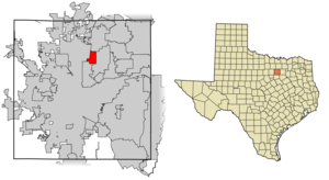
mapsize = 250x200px
map_caption = Location of Watauga in Tarrant County,Texas
mapsize1 =
map_caption1 =
image_dot_
dot_mapsize =
dot_map_caption =
dot_x =
dot_y =
pushpin_
pushpin_label_position =
pushpin_map_caption =
pushpin_mapsize =
subdivision_type = Country
subdivision_name =United States
subdivision_type1 = State
subdivision_name1 =Texas
subdivision_type2 = County
subdivision_name2 = Tarrant
subdivision_type3 =
subdivision_name3 =
subdivision_type4 =
subdivision_name4 =
government_footnotes =
government_type =
leader_title =
leader_name =
leader_title1 =
leader_name1 =
leader_title2 =
leader_name2 =
leader_title3 =
leader_name3 =
leader_title4 =
leader_name4 =
established_title =
established_date =
established_title2 =
established_date2 =
established_title3 =
established_date3 =
area_magnitude =
unit_pref = Imperial
area_footnotes =
area_total_km2 = 10.8
area_land_km2 = 10.8
area_water_km2 = 0
area_total_sq_mi = 4.2
area_land_sq_mi = 4.2
area_water_sq_mi = 0
area_water_percent =
area_urban_km2 =
area_urban_sq_mi =
area_metro_km2 =
area_metro_sq_mi =
area_blank1_title =
area_blank1_km2 =
area_blank1_sq_mi =
population_as_of = 2000
population_footnotes =
population_note =
population_total = 21908
population_density_km2 = 2028.5
population_density_sq_mi = 5256.9
population_metro =
population_density_metro_km2 =
population_density_metro_sq_mi =
population_urban =
population_density_urban_km2 =
population_density_urban_sq_mi =
population_blank1_title =
population_blank1 =
population_density_blank1_km2 =
population_density_blank1_sq_mi =
timezone = CST
utc_offset = -6
timezone_DST = CDT
utc_offset_DST = -5
latd = 32 |latm = 52 |lats = 17 |latNS = N
longd = 97 |longm = 14 |longs = 57 |longEW = W
elevation_footnotes =
elevation_m = 185
elevation_ft = 607
postal_code_type =ZIP code
postal_code = 76148
area_code = 817
blank_name = FIPS code
blank_info = 48-76672GR|2
blank1_name = GNIS feature ID
blank1_info = 1376659GR|3
website = http://www.ci.watauga.tx.us/
footnotes =Watauga is a city in Tarrant County,
Texas ,United States . The population was 21,908 at the 2000 census.Geography
Watauga is located at coor dms|32|52|17|N|97|14|57|W|city (32.871416, -97.249122)GR|1.
According to the
United States Census Bureau , the city has a total area of 4.2square mile s (10.8km² ), all of it land.History
The first settlers came to the area in 1843. [ [http://www.ci.watauga.tx.us/development/about.htm Town website] ] The area was first large farms and ranches, and took it name from the
Cherokee word for "village of many springs." Watauga is also the name of a pre-Revolutionary War settlement in East Tennessee, theWatauga Association , and many Tennesseans later came to Texas. TheTexas and Pacific Railway came through the area in 1881, which spurred a settlement. Watauga received a railroad station, then and a post office in 1883. The population was 65 in the mid 1930s and 40s, when the railroad station had closed. The population then grew due to defense plants to over 1000 in the 1960s. The population continued to grow to 7050 in 1976, and 20,000 in 1990. [ [http://www.tshaonline.org/handbook/online/articles/WW/hew1.html Handbook of Texas Online] ]Demographics
As of the
census GR|2 of 2000, there were 21,908 people, 7,145 households, and 5,944 families residing in the city. Thepopulation density was 5,256.9 people per square mile (2,028.5/km²). There were 7,275 housing units at an average density of 1,745.7/sq mi (673.6/km²). The racial makeup of the city was 87.05% White, 2.27% African American, 0.64% Native American, 3.69% Asian, 0.20% Pacific Islander, 3.91% from other races, and 2.23% from two or more races. Hispanic or Latino of any race were 10.66% of the population.There were 7,145 households out of which 49.7% had children under the age of 18 living with them, 68.8% were married couples living together, 10.0% had a female householder with no husband present, and 16.8% were non-families. 12.8% of all households were made up of individuals and 2.7% had someone living alone who was 65 years of age or older. The average household size was 3.04 and the average family size was 3.33.
In the city the population was spread out with 32.3% under the age of 18, 7.2% from 18 to 24, 36.5% from 25 to 44, 19.3% from 45 to 64, and 4.7% who were 65 years of age or older. The median age was 32 years. For every 100 females there were 97.9 males. For every 100 females age 18 and over, there were 94.2 males.
The median income for a household in the city was $56,751, and the median income for a family was $57,969. Males had a median income of $40,468 versus $28,360 for females. The
per capita income for the city was $19,872. About 3.5% of families and 3.9% of the population were below thepoverty line , including 3.9% of those under age 18 and 4.7% of those age 65 or over.Education
The City of Watauga is served by two independent school districts - Birdville and Keller.
References
External links
* [http://www.ci.watauga.tx.us/ City of Watauga website]
Wikimedia Foundation. 2010.