- Dallas County, Texas
-
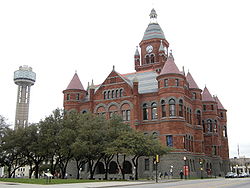
Dallas County, Texas The former Dallas County Courthouse in Dallas.
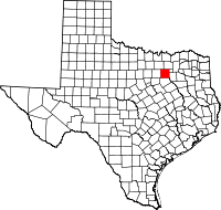
Location in the state of Texas
Texas's location in the U.S.Founded March 30, 1846 Named for George Mifflin Dallas Seat Dallas Area
- Total
- Land
- Water
908 sq mi (2,353 km²)
880 sq mi (2,278 km²)
29 sq mi (75 km²), 3.19%Population
- (2010)
- Density
2,368,139
2,692/sq mi (1,039.57/km²)Website www.dallascounty.org Dallas County is a county located in the U.S. state of Texas within the Dallas–Fort Worth–Arlington metropolitan area (colloquially referred to as the Dallas/Fort Worth Metroplex). As of 2010, the county had an official population of 2,368,139 and is now the ninth most populous county in the United States. Dallas county was founded in 1846 and was named for George Mifflin Dallas, the 11th Vice President of the United States.
Its county seat is Dallas[1], which is also the largest city in the county, the third-largest city in Texas, and the eighth-largest city in the United States. Dallas County is the most populous county within the metropolitan area and contains the largest of its principal cities.
Contents
Geography
According to the U.S. Census Bureau, the county has a total area of 908 square miles (2,352 km2), of which 880 square miles (2,279 km2) is land and 29 square miles (75 km2) (3.19%) is water.
Major Highways
 Interstate 20
 Interstate 30
 Interstate 35E
 Interstate 45
 Interstate 635
 Dallas North Tollway
- President George Bush Turnpike
 State Highway 5
 State Highway 66
 State Highway 78
 State Highway 114
 State Highway 121
 State Highway 161
 State Highway 183
 State Highway 190
 State Highway 289
 State Highway 342
 State Highway 352
 State Highway 356
 Loop 12
Adjacent counties
- Collin County (north)
- Rockwall County (northeast)
- Kaufman County (east)
- Ellis County (south)
- Tarrant County (west)
- Denton County (northwest)
- Johnson County (southwest)
Demographics
Historical populations Census Pop. %± 1850 2,743 — 1860 8,665 215.9% 1870 13,814 59.4% 1880 33,488 142.4% 1890 67,042 100.2% 1900 82,726 23.4% 1910 135,748 64.1% 1920 210,551 55.1% 1930 325,691 54.7% 1940 398,564 22.4% 1950 614,799 54.3% 1960 951,527 54.8% 1970 1,327,321 39.5% 1980 1,556,390 17.3% 1990 1,852,810 19.0% 2000 2,218,899 19.8% 2010 2,368,139 6.7% As of the census[2] of 2000, there were 2,218,899 people, 807,621 households, and 533,837 families residing in the county. The population density was 2,523 people per square mile (974/km²). There were 854,119 housing units at an average density of 971/sq mi (375/km²). The racial makeup of the county was 58.35% White, 20.31% Black or African American, 0.56% Native American, 3.98% Asian, 0.06% Pacific Islander, 14.04% from other races, and 2.70% from two or more races. 29.87% of the population were Hispanic or Latino of any race.
There were 807,621 households out of which 35.10% had children under the age of 18 living with them, 46.90% were married couples living together, 14.10% had a female householder with no husband present, and 33.90% were non-families. 27.30% of all households were made up of individuals and 5.90% had someone living alone who was 65 years of age or older. The average household size was 2.71 and the average family size was 3.34.
In the wider county, the population was spread out with 27.90% under the age of 18, 10.70% from 18 to 24, 34.40% from 25 to 44, 18.90% from 45 to 64, and 8.10% who were 65 years of age or older. The median age was 31 years. For every 100 females there were 99.80 males. For every 100 females age 18 and over, there were 98.00 males.
The median income for a household in the county was US$43,324, and the median income for a family was $49,062. Males had a median income of $34,988 versus $29,539 for females. The per capita income for the county was $22,603. About 10.60% of families and 13.40% of the population were below the poverty line, including 18.00% of those under age 18 and 10.50% of those age 65 or over.
Government
Dallas County is governed by a Commissioners Court. The Dallas County Commissioners Court consists of the County Judge (the chairperson of the Court) who is elected County-wide and four Commissioners who are elected by the voters in each of four districts.
The Commissioners Court is the policy-making body for the County; in addition, the County Judge is the senior executive and administrative position in the County. While the cities in the County handle many tasks in local government, the County holds responsibility for the following:
"The Commissioners Court sets the County tax rate, adopts the budget, appoints boards and commissions, approves grants and personnel actions, and oversees the administration of county government. Each commissioner also supervises a Road and Bridge District. The Commissioners Court also approves the budget and sets the tax rate for the hospital district, which is charged with the responsibility for providing acute medical care for citizens who otherwise would not receive adequate medical services."[3]
The total 2010 fiscal year budget is approximately $871 million USD.[4]
Currently (November 2010), the major elected officials are[5]
Position Name Party County Judge Clay Jenkins Democratic Commissioner, Precinct 1 Maurine Dickey Republican Commissioner, Precinct 2 Mike Cantrell Republican Commissioner, Precinct 3 John Wiley Price Democratic Commissioner, Precinct 4 Elba Garcia Democratic District Attorney Craig Watkins Democratic District Clerk Gary Fitzsimmons Democratic County Clerk John Warren Democratic Sheriff Lupe Valdez Democratic Tax Assessor-Collector John Ames Democratic Treasurer Joe Wells Democratic There are 6 congressional districts either entirely or partly within Dallas County. There are 5 Republicans and 1 Democrat.
Representative Party Home Town/City District Sam Johnson R Plano 3 Jeb Hensarling R Dallas 5 Kenny Marchant R Coppell 24 Michael C. Burgess R Lewisville 26 Eddie Bernice Johnson D Dallas 30 Pete Sessions R Dallas 32 There are 5 Texas Senate districts either entirely or partly within Dallas County. There are 4 Republicans and 1 Democrat.
Senator Party Home Town/City District Bob Deuell R Greenville 2 Florence Shapiro R Plano 8 Chris Harris R Arlington 9 John Carona R Dallas 16 Royce West D Dallas 23 There are 16 members of the Texas House of Representatives who are based in Dallas County. There are 10 Republicans and 6 Democrats.
Representative Party Home Town/City District ↑ Eric Johnson D Dallas 100 Cindy Burkett R Mesquite 101 Stefani Carter R Dallas 102 Rafael Anchia D Dallas 103 Roberto R. Alonzo D Dallas 104 Linda Harper-Brown R Irving 105 Rodney E. Anderson R Grand Prairie 106 Kenneth Sheets R Dallas 107 Dan Branch R Dallas 108 Helen Giddings D De Soto 109 Barbara Mallory Caraway D Dallas 110 Yvonne Davis D Dallas 111 Angie Chen Button R Richardson 112 Joe Driver R Garland 113 Will Hartnett R Dallas 114 Jim Jackson R Carrollton 115 Politics
Presidential Election Results 1960-2008 Year Democrat Republican 2008 57.5% 424,468 41.9% 309,477 2004 49.0% 336,641 50.4% 346,246 2000 44.9% 275,308 52.6% 322,345 1996 46.0% 255,766 46.8% 260,058 1992 35.0% 231,412 38.7% 256,007 1988 40.9% 243,198 58.4% 347,094 1984 33.4% 203,592 66.4% 405,444 1980 36.8% 190,459 59.2% 306,682 1976 42.3% 196,303 56.7% 263,081 1972 29.6% 129,662 69.5% 305,112 1968 34.1% 123,809 50.7% 184,193 1964 54.7% 166,472 45.1% 137,065 1960 37.0% 88,876 62.2% 149,369 Dallas County has voted for the Republican presidential candidate in almost every election since 1960; the only exceptions being in 1964 and 2008. More recently however, it has gradually shifted more Democratic in recent elections. The Democratic gains are primarily due to the city of Dallas, which has become a stronghold of that party.
In the United States House of Representatives, districts 30 and 32 are entirely within the county and districts 3, 5, 24, and 26 include portions of Dallas County. Five of the six districts are currently represented by Republicans. In order of district number they are Sam Johnson (R-03), Jeb Hensarling (R-05), Kenny Marchant (R-24), Michael C. Burgess (R-26), Eddie Bernice Johnson (D-30), and Pete Sessions (R-32).[6]
Cities and towns
- Rowlett†
- Sachse†
- Sand Branch (unincorporated)
- Seagoville†
- Sunnyvale
- University Park
- Wilmer
- Wylie†
†Denotes a municipality whose physical boundaries extend beyond Dallas County
Historical communities
- Bird's Fort
- Buckingham (Annexed by Richardson in 1996)
- Embree (merged into Garland in 1887)
- Fruitdale (annexed by Dallas in 1964)
- Duck Creek (merged into Garland in 1887)
- Letot (Northwest Dallas County, annexed by Dallas)[7]
- Long Creek (Merged into Sunnyvale in 1953)
- Hatterville (Merged into Sunnyvale in 1953)
- New Hope (Merged into Sunnyvale in 1953 - not to be confused with the Collin County town of the same name)
- Oak Cliff (Annexed by Dallas in 1903)
- Penn Springs (Annexed by Duncanville in 1947)
- Pleasant Grove (Annexed by Dallas by 1962)
- Renner (annexed by Dallas in 1983)
- Tripp (Merged into Sunnyvale in 1953)
- Trinity Mills (Annexed by Carrollton)[8]
Education
The following school districts serve Dallas County:
- Carrollton-Farmers Branch ISD (partly in Denton County)
- Cedar Hill ISD
- Coppell ISD
- Dallas ISD
- DeSoto ISD
- Duncanville ISD
- Ferris ISD (mostly in Ellis County)
- Garland ISD
- Grand Prairie ISD
- Grapevine-Colleyville ISD (mostly in Tarrant County)
- Highland Park ISD
- Irving ISD
- Lancaster ISD
- Mesquite ISD
- Richardson ISD
- Sunnyvale ISD
Transportation
Love Field, located in Dallas and in Dallas County, serves many domestic passengers.
Dallas-Fort Worth International Airport partially located in the city of Irving in Dallas County and Grapevine and Euless in Tarrant County.
Dallas Area Rapid Transit provides bus and rail service to many cities in Dallas County, with Dallas being the largest.
The Trinity Railway Express provides commuter rail service to Tarrant County, including downtown Fort Worth.
Government and infrastructure
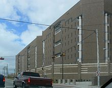
Dallas County operates several jail facilities. They include:[9]
- 111 Riverfront Blvd (Dallas)
- North Tower Jail
- South Tower Jail - also known as the "Suzanne Kays Tower"
- West Tower Jail
- Government Center Jail - 600 Commerce Street (Dallas)
- Decker Detention Center - 899 North Stemmons Freeway (Dallas)
- (formerly) Suzanne Kays Jail - 521 North Industrial Boulevard (Dallas) - population integrated into the South Tower; demolished to clear way for the Trinity River Project[10]
Texas Department of Criminal Justice operates the Hutchins Unit state jail for men in an unincorporated area adjacent to Hutchins.[11] Corrections Corporation of America operates the Dawson Unit, a co-gender state jail in Downtown Dallas, under contract.[12]
Federal Correctional Institution, Seagoville is located in Seagoville.
See also
- Dallas County District Attorney
- National Register of Historic Places listings in Dallas County, Texas
References
- ^ "Find a County". National Association of Counties. http://www.naco.org/Counties/Pages/FindACounty.aspx. Retrieved 2011-06-07.
- ^ "American FactFinder". United States Census Bureau. http://factfinder.census.gov. Retrieved 2008-01-31.
- ^ http://www.dallascounty.org/
- ^ http://www.dallascounty.org/department/budget/documents/FY2010ApprovedBudgetDetail.pdf
- ^ http://www.dallascounty.org/department/districtclerk/forms/COMBINED_MASTER_FINAL_OFFICIALS_20100201.pdf
- ^ http://elections.sos.state.tx.us/elchist.exe
- ^ Rose-Mary Rumbley, "LETOT, CLEMENT" Handbook of Texas Online, accessed December 26, 2010.
- ^ Trinity Mills, Texas from the Handbook of Texas Online. By Matthew Hayes Nall. Retrieved on 31 March 2007.
- ^ "Jail Information." Dallas County Sheriff's Office. Accessed September 14, 2008.
- ^ Suzanne Kays Jail to be Torn Down - Dallas Morning News CRIME Blog
- ^ "HUTCHINS (HJ)." Texas Department of Criminal Justice. Accessed September 14, 2008.
- ^ "DAWSON (JD)." Texas Department of Criminal Justice. Accessed September 14, 2008.
External links
- Dallas County Government official site
- Dallas County from the Handbook of Texas Online
- History of Dallas County, Texas: from 1837 to 1887 by John Henry Brown, published 1887, hosted by the Portal to Texas History.
- Memorial and biographical history of Dallas County, Texas published 1892, hosted by the Portal to Texas History.
- Official directory, taxpayers of Dallas County, Texas published 1896, hosted by the Portal to Texas History.
- Dallas County Jail stories.

Denton County Collin County Rockwall County 
Tarrant County 
Kaufman County  Dallas County, Texas

Johnson County Ellis County Municipalities and communities of Dallas County, Texas Cities Balch Springs | Carrollton‡ | Cedar Hill‡ | Cockrell Hill | Combine‡ | Coppell‡ | Dallas‡ | DeSoto | Duncanville | Farmers Branch | Ferris‡ | Garland‡ | Glenn Heights‡ | Grand Prairie‡ | Grapevine‡ | Hutchins | Irving | Lancaster‡ | Lewisville‡ | Mesquite‡ | Ovilla‡ | Richardson‡ | Rowlett‡ | Sachse‡ | Seagoville‡ | University Park | Wilmer | Wylie‡
Towns Unincorporated
communitiesAlpha | Sand Branch
Footnotes ‡This populated place also has portions in an adjacent county or counties
Dallas–Fort Worth–Arlington Counties Major cities Cities and towns
100k-300kCarrollton • Denton • Frisco • Garland • Grand Prairie • Irving • McKinney • Mesquite • Plano • RichardsonCities and towns
25k-99kAllen • Bedford • Cedar Hill • Cleburne • The Colony • Coppell • DeSoto • Duncanville • Euless • Farmers Branch • Flower Mound • Grapevine • Haltom City • Highland Village • Hurst • Keller • Lancaster • Lewisville • Mansfield • North Richland Hills • Rockwall • Rowlett • WylieCities and towns
10k-25kAddison • Balch Springs • Benbrook • Burleson • Colleyville • Corinth • Ennis • Forest Hill • Greenville • Saginaw • Seagoville • Southlake • Terrell • University Park • Watauga • Waxahachie • Weatherford • White SettlementCategories:- Texas counties
- Dallas – Fort Worth Metroplex
- Dallas County, Texas
- 1846 establishments in the United States
Wikimedia Foundation. 2010.


