- U.S. Route 82 in Texas
-
U.S. Highway 82
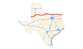
Route information Maintained by TxDOT Length: 504.135 mi[1] (811.327 km) Existed: 1935 – present Major junctions West end:  US 82
US 82 US 380 in Plains

 US 62 / US 385 in Brownfield


 I-27 / US 84 / US 87 in Lubbock
 US 83 in Guthrie


 US 183 / US 277 / US 283 in Seymour

 US 281 / US 287 in Wichita Falls
 US 81 in Ringgold

 I-35 / US 77 in Gainesville
 US 377 in Whitesboro
 US 75 in Sherman
 US 69 in Bells
 US 271 in Paris
 US 259 in De Kalb
 I-30 near New Boston


 US 59 / US 67 / US 71 in Texarkana
East end:  U.S. 82 in Texarkana
Highway system United States Numbered Highways
List • Bannered • Divided • ReplacedHighways in Texas
Interstate • U.S. • TX (Loops – Spurs – Rec – FM)←  SH 81
SH 81SH 82  →
→In the U.S. state of Texas, U.S. Route 82 is a U.S. Highway that begins on the New Mexico border and heads east through West Texas and Lubbock to the Arkansas border at Texarkana.
Contents
Route description
New Mexico–Texas state line to Wichita Falls
US 82 crosses into Texas from New Mexico at Texas Farm to Market Road 769, turning northeastward toward Plains, where it merges with US 380. US 82 is co-signed with US 380 from Plains to Brownfield, where it joins US 62, and US 380 leaves the route. US 82/62 continues northeastward toward Lubbock.
In Lubbock, US 82 and US 62 split, where US 82 is being upgraded to a full access freeway, to be named the Marsha Sharp Freeway, in honor of retired Texas Tech Lady Raiders basketball coach Marsha Sharp. On the east side of the city, it once again merges with US 62 (along with State Highway 114) where it continues eastward through Ralls, where US 62 makes a sharp turn to the north and leaves the route. US 82 continues eastward across the level plains of the Llano Estacado to Crosbyton and then dips downward as it crosses the White River of Blanco Canyon, where the Texas Department of Transportation maintains the Silver Falls Rest Area with facilities and hiking trails. After climbing out of Blanco Canyon, US 82 eventually exits the Llano Estacado and enters the rolling plains near Dickens.
US 82/SH 114 continues eastward as a co-signed route until Seymour, where it merges with U.S. Highways 183, 277 and 283, with US 183 and 283 leaving the route at Mabelle. US 82/277 continues eastward to Wichita Falls, merging with US 287 just south of downtown.
Wichita Falls to Texarkana and Texas–Arkansas state line
US 82 leaves US 287 at Henrietta and continues east towards the small towns of Nocona, Texas (beginning as a four-lane divided highway), St. Jo, Texas and Muenster, Texas and crossing Interstate 35 in Gainesville at a partial cloverleaf interchange. The highway continues east towards Whitesboro, Texas and Sherman, Texas where it crosses US Highway 75 at a three-level diamond interchange. Prior to the 1990s, the two highways ran concurrently on the route of Texas State Highway 56 before being rerouted northeast of Sherman on its present-day route. The highway continues east to Bells, Texas where US 82 cross US Route 69.
In Bonham, Texas, US 82 crosses Texas SH 121 while the route runs parallel with SH 56 until Honey Grove, Texas where SH 56 ends. US 82 enters Paris, Texas at a diamond interchange where it runs concurrent with Texas Loop 286 on the north side of the city as a Business Route runs through the center of the city before rejoining on the east side of Paris. At a diamond interchange on the north side of Paris, US 82/TX Loop 286 meets with US 271 where both highways run concurrent on the northeast side of town before US 82 branches off at another diamond interchange on on the east side of Paris. After passing around Clarksville, Texas and other smaller towns the highway is crossed by Interstate 30 east of New Boston, Texas at a partial cloverleaf and continues to run parallel to IH 30 into Arkansas through downtown Texarkana.[2]
Future
The Marsha Sharp Freeway, named for former Texas Tech Lady Raiders basketball coach Marsha Sharp, is currently being built along US 82 in Lubbock, Texas. In 1998, funding was first received. The five-phase project is scheduled to be completed in 2015.
Phase 2 of the project was scheduled to be completed in December 2008 at a cost of $140 million. It involved construction of the freeway from Salem Avenue to Avenue L and erecting interchanges at 19th Street, Quaker Avenue, Fourth Street, and Avenue Q in Lubbock.[3]
-
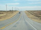
US 82 Outside of Henrietta, TX
-

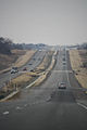
The Marsha Sharp Freeway on U.S. Highway 82 in Lubbock
-
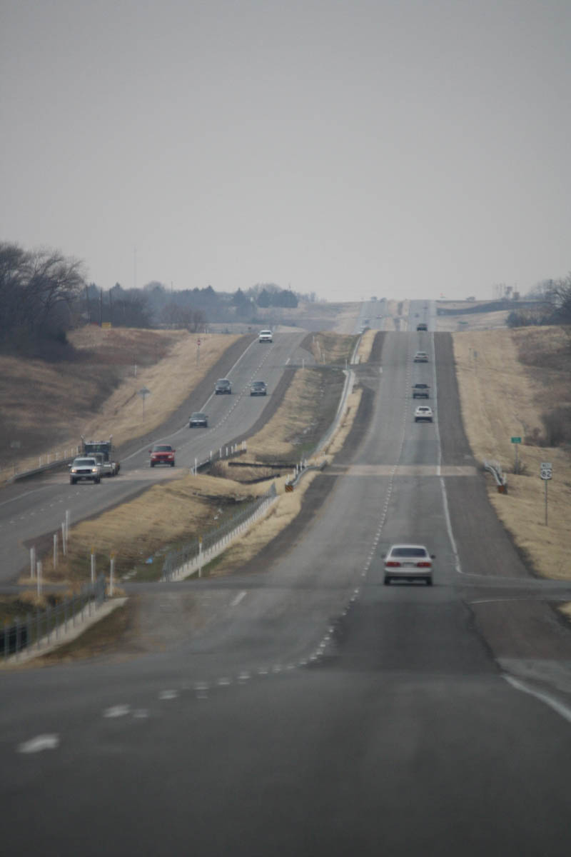
Heading west on US-82 out of Sherman, TX
Junction List
County Location # Destination Notes Yoakum Plains US 380 west – RoswellWest end of US 380 overlap  SH 214 – Morton, Seminole
 FM 1780 – Whiteface
Terry  FM 402 – Wellman
 FM 303
Brownfield  SH 137 – Lamesa US 62 west / US 380 east / US 385 south – Seminole
East end of US 380 overlap; West end of US 62/ 385 overlap US 385 north – LevellandEast end of US 385 overlap  FM 211 – Needmore, New Home
Hockley Ropesville 
 FM 41 / FM 168 – Sundown, Smyer
Lubbock  FM 1585 east (130th Street)
West end of FM 1585 overlap FM 1585 west (114th Street)East end of FM 1585 overlap Wolfforth  Loop 193 east – Wolfforth
 FM 179 (Dowden Road)
West end of freeway Lubbock 82nd Street Westbound exit and eastbound entrance; east end of freeway  Spur 327 east
Interchange; no westbound exit  Loop 289
West end of freeway Loop 289 southWestbound exit and eastbound entrance 34th Street, Slide Road Quaker Avenue No eastbound entrance  US 62 east / SH 114 – Levelland
East end of US 62 overlap Texas Tech Parkway – Texas Tech 4th Street, University Avenue US 84 (Avenue Q) – Littlefield, SlatonEastbound exit and westbound entrance; west end of freeway I-27 (US 87) – Amarillo, Tohoka
US 87 Bus. south (Avenue A) PR 18 – Mackenzie Park US 62 west (Idalou Road) / SH 114 west
Interchange; west end of US 62/ SH 114 overlap Loop 289Interchange  FM 2641 west (Kent Street)
 FM 1729 south
Idalou  FM 400 – Slaton, Plainview
 FM 789 south – Acuff
West end of FM 789 overlap FM 789 north – PetersburgEast end of FM 789 overlap Crosby Lorenzo  FM 378 north – Lockney
West end of FM 378 overlap FM 378 southEast end of FM 378 overlap  FM 2236 north
 FM 2576 south
Ralls US 62 east – FloydadaEast end of US 62 overlap  SH 207 – Post
 FM 1831 south
Crosbyton  FM 651 – Post, Lakeview
 FM 2591 north
 FM 28 north
 FM 638 south – Spur
Dickens  FM 264 north – McAdoo
 Loop 120 east
Dickens  SH 70 – Spur, Matador Loop 120
 FM 265 north
 FM 2941 north
King US 83 – Aspermont, Guthrie, PaducahInterchange  SH 222 east – Knox City
Knox Benjamin  SH 6 – Crowell, Knox City
 FM 267 – Rhineland
 FM 266 – Goree
Baylor  FM 2069 north
 FM 1789 north
Seymour 


US 183 Bus. south / US 277 Bus. south / SH 114 east – Throckmorton, Haskell, OlneyEast end of SH 114 overlap; west end of US Bus 183/ 277 overlap  FM 1919 north – Crowell US 183 south / US 277 south / US 283 south – Throckmorton, Haskell
East end of US Bus 183/ 277 overlap; West end of US 183/ 277/ 283 overlap Mabelle  US 183 north / US 283 north / FM 1790 south – Vernon
East end of US 183/ 283 overlap Archer  FM 2846 north
 FM 368 south
 SH 25 – Electra, Archer City
US 82 Bus. east / US 277 Bus. north – Holliday FM 368 – Holliday
US 82 Bus. west / US 277 Bus. south – HollidayInterchange Wichita  SH 258 west
Wichita Falls  FM 369 (Southwest Parkway)
West end of freeway
US 277 Bus. north (Seymour Highway) / Allendale RoadWestbound exit and eastbound entrance Barnett Road Fairway Boulevard McNiel Avenue Lawrence Road/ Lebanon Road No eastbound exit Kemp Boulevard Taft Boulevard Harrison Street Westbound exit and eastbound entrance Brook Avenue Eastbound exit and westbound entrance Kell Boulevard Eastbound exit and westbound entrance  US 277 north / US 281 north / US 287 north to I-44 – Vernon, Burkburnett, Lawton
East end of US 277 overlap; west end of US 281/ 287 overlap  Loop 473 (Jacksboro Highway)
 US 281 south / SH 79 south – Jacksboro, Archer City
East end of US 281/ west end of SH 79 overlap Old Windthorst Road SH 79 north – PetroliaEast end of SH 79 overlap Fisher Road Clay
US 287 Bus. northEast end of freeway  Loop 47 east – Jolly
 FM 2393 – Jolly
Interchange Loop 47 west – JollyMontague Ringgold  Loop 19 north – Ringgold US 81 – Bowie, Waurika
Interchange US 287 south – Decatur, Fort WorthInterchange; east end of US 287 overlap Henrietta  SH 148 north – Petrolia
West end of SH 148 overlap SH 148 south – JacksboroEast end of SH 148 overlap  FM 1197 north
 Spur 510 south
 FM 1134 south
 FM 2232 north
Belcherville  FM 1816
Nocona  SH 175 south – Montague
 FM 103 north – Spanish Fort
 FM 1815 north – Bonita
St. Jo  SH 59 south – Bowie
 FM 677 – Forestburg, Illinois Bend
 FM 2382 east – Bulcher
Cooke Muenster  FM 373 – Bulcher
 FM 445 south / FM 2739 north – Myra, Marysville
 FM 1198 south
Lindsay  FM 1199
 FM 3108 south
 FM 1201 north
Gainesville I-35 – Denton, Dallas, Fort Worth, Oklahoma CityInterchange Dixon Street Interchange; eastbound exit and westbound entrance  FM 372 (Grand Avenue)
Interchange  FM 3092 south
 FM 371 north – Callisburg
 FM 678
 FM 107 north
Grayson 622  SH 56 east – Whitesboro
Intercahnge Whitesboro 624 US 377 – Whitesboro, Pilot PointInterchange 628  FM 901
Intercahnge  SH 289 – Pottsboro, Celina
Sherman 640  FM 1417
West end of freeway 641  FM 131 (Travis Street)
Eastbound exit and westbound entrance 642 US 75 (Sam Rayburn Freeway) – Denison, Durant, DallasSigned as exit 642A westbound 642B North Loy Lake Road Westbound exit and eastbound entrance 643  SH 91 (Lake Texoma Parkway) – Lake Texoma
East end of freeway FM 1417 south653 US 69 – Denison, GreenvilleInterchange 654  FM 1897 (Old Ambrose Road) – Bells
Interchange Fannin 658  FM 1752 – Savoy
Interchange  FM 898 – Ector
Bonham 670  SH 121 – McKinney
West end of freeway 671  SH 78 – Bailey, Durant
East end of freeway  FM 897 south
 FM 1743 south – Windom
 FM 1396
Honey Grove 686  FM 100 – Honey Grove
Interchange SH 56 west – Honey GroveLamar  FM 38 north
 FM 1507 east – Petty
 FM 137 south – Petty FM 38 – Brookston
 FM 1510 west
Paris
 US 82 Bus. east (Bonham Street) / Loop 286 south – Paris
East end of Loop 286 overlap  FM 79 (NW 19th Street)
Interchange 
US 271 north / US 271 Bus. south – Hugo, ParisInterchange; west end of US 271 overlap Fitzhugh Avenue Interchange  SH 139 east
 FM 195
Interchange
US 271 south / US 82 Bus. west (Lamar Avenue) / Loop 286 south – Mount Pleasant, ParisInterchange; East end of US 271/ Loop 286 overlap Reno  FM 1508 south (Airport Road)
Blossom  FM 196 north – Novice
 FM 194 south – Pattonville
 FM 1502 north
Red River Detroit  FM 410
 FM 2573 east – Bagwell FM 2573 west – Bagwell
Clarksville  FM 2825 south
 US 82 Bus. west / SH 37 south – Clarksville, Mount Vernon
West end of SH 37 overlap  SH 37 north / Bus. SH 37 south – Idabel, Clarksville
Interchange; east end of SH 37 overlap  FM 1159
US 82 Bus. west – Clarksville FM 114 east – English
 FM 412 south
Annona  FM 44 – English, Annona
 FM 1699 north
Avery  FM 911 north (San Antonio Drive)
US 82 Bus. east – Avery
US 82 Bus. west – AveryBowie  FM 1326 north US 259 – Daingerfield, Idabel
Interchange De Kalb  FM 992
Malta  FM 2789 north
 SH 98 south / FM 3378 north I-30 – Dallas, Texarkana
Interchange New Boston  SH 8 – Boston
Interchange  Spur 68 north
Hooks  FM 560 north (Main Street)
 FM 1398 north (Precinct Road)
Leary  Spur 74 north FM 1398 north (Barkman Creek Road)
 FM 2253 north (Leary Road)
Nash  FM 2148
 FM 989 (Kings Highway)
Texarkana US 59 – Marshall SH 93 (Summerhill Road)
 Loop 14 north (Texas Boulevard) US 67 south (8th Street, 7th Street)
West end of US 67 overlap US 71 north (State Line Avenue) – AshdownWest end of US 71 overlap References
- ^ Texas Department of Transportation. "Highway Designation File - U.S. Highway No. 82". http://www.dot.state.tx.us/tpp/hwy/US/US0082.htm. Retrieved 2008-03-05.
- ^ Google, Inc. Google Maps – overview map of US 82 (Map). Cartography by Google, Inc. http://maps.google.com/maps?f=d&hl=en&geocode=9057210035096396317,33.089320,-103.062810%3B8980626385590654323,33.589030,-101.881249%3B2746237732316299018,33.659940,-101.284550%3B12660922287273459667,33.689294,-98.998079%3B8528934906615126807,33.813150,-98.005160%3B4936721241436833516,33.661458,-95.598691%3B16651740040287373293,33.683060,-95.543790%3B14899021823869182982,33.661639,-95.510305%3B14817617784561091949,33.460779,-94.390912%3B6200867972322077763,33.466883,-94.272475%3B5175639916054505956,33.452306,-94.180382%3B1181495825108737753,33.438757,-94.085655%3B8209064082996360802,33.431528,-94.051857%3B11771126202873122088,33.427250,-94.043109&saddr=US-82+%4033.089320,+-103.062810&daddr=Tech+Fwy%2FUS-82+E+%4033.589030,+-101.881249+to:TX-114+E%2FUS-82+E+%4033.659940,+-101.284550+to:US-277%2FUS-82+%4033.689294,+-98.998079+to:US-82+%4033.813150,+-98.005160+to:Unknown+road+%4033.661458,+-95.598691+to:TX-286-LOOP+NE%2FUS+271+S%2FUS-82+E+%4033.683060,+-95.543790+to:Unknown+road+%4033.661639,+-95.510305+to:US-82%2FUS-82+E+%4033.460779,+-94.390912+to:E+Ave+A%2FUS-82+%4033.466883,+-94.272475+to:W+New+Boston+Rd%2FUS-82+%4033.452306,+-94.180382+to:New+Boston+Rd%2FUS-82+%4033.438757,+-94.085655+to:Texas+Blvd%2FUS-82+%4033.431528,+-94.051857+to:N+State+Line+Ave%2FUS+71+%4033.427250,+-94.043109&via=1,2,3,4,5,6,7,8,9,10,11,12&doflg=ptm&sll=33.49312,-98.55296&sspn=11.185697,15.79834&ie=UTF8&t=h&z=6. Retrieved 2008-03-05.
- ^ "Marsha Sharp freeway construction could complicate campus traffic until 2008". The Daily Toreador. April 13, 2007. http://media.www.dailytoreador.com/media/storage/paper870/news/2007/04/13/News/Marsha.Sharp.Freeway.Construction.Could.Complicate.Campus.Traffic.Until.2008-2839780.shtml?reffeature=htmlemailedition.
Yoakum County highways U.S. Highways US 82 • US 380
State Highways Farm and Ranch to Market Roads FM 213 • FM 435 • FM 769 • FM 1622 • FM 1780 • FM 1939 • FM 2055 • FM 2196
Baylor County highways U.S. Highways Bannered U.S. Highways Bus. US 183-B
State Highways State Loops and Spurs Spur 334
Farm and Ranch to Market Roads FM 422 • FM 1152 • FM 1153 • FM 1285 • FM 1286 • FM 1608 • FM 1789 • FM 1790 • RM 1919 • FM 2069 • FM 2070 • FM 2180 • FM 2374 • FM 2395 • FM 2582
Archer County highways U.S. Highways Bannered U.S. Highways Bus. US 82-F • Bus. US 277-B
State Highways Farm and Ranch to Market Roads Fannin County highways U.S. Highways US 69 • US 82
Bannered U.S. Highways Bus. US 69-B
State Highways State Highway Business Routes Bus. SH 121-D
State Loops and Spurs Loop 205 • Spur 311
Park and Recreational Roads PR 24 • PR 34 • RE 3
Farm and Ranch to Market Roads FM 64 • FM 68 • FM 79 • FM 87 • FM 100 • FM 151 • FM 271 • FM 272 • FM 273 • FM 274 • FM 409 • FM 814 • FM 815 • FM 816 • FM 824 • FM 896 • FM 897 • FM 898 • FM 904 • FM 981 • FM 1396 • FM 1550 • FM 1552 • FM 1553 • FM 1629 • FM 1743 • FM 1752 • FM 1753 • FM 2029 • FM 2077 • FM 2216 • FM 2456 • FM 2554 • FM 2645 • FM 2815 • FM 2990 • FM 3297 • FM 3321
Categories:- U.S. Highways in Texas
- Transportation in Bowie County, Texas
- Transportation in Red River County, Texas
- Transportation in Lamar County, Texas
- Transportation in Fannin County, Texas
- Transportation in Grayson County, Texas
- Transportation in Cooke County, Texas
- Transportation in Montague County, Texas
- Transportation in Clay County, Texas
- Transportation in Wichita County, Texas
- Transportation in Archer County, Texas
- Transportation in Baylor County, Texas
- Transportation in Knox County, Texas
- Transportation in King County, Texas
- Transportation in Dickens County, Texas
- Transportation in Crosby County, Texas
- Transportation in Lubbock County, Texas
- Transportation in Hockley County, Texas
- Transportation in Terry County, Texas
- Transportation in Yoakum County, Texas
-


Wikimedia Foundation. 2010.