- U.S. Route 281
Infobox U.S. Route
article_route=281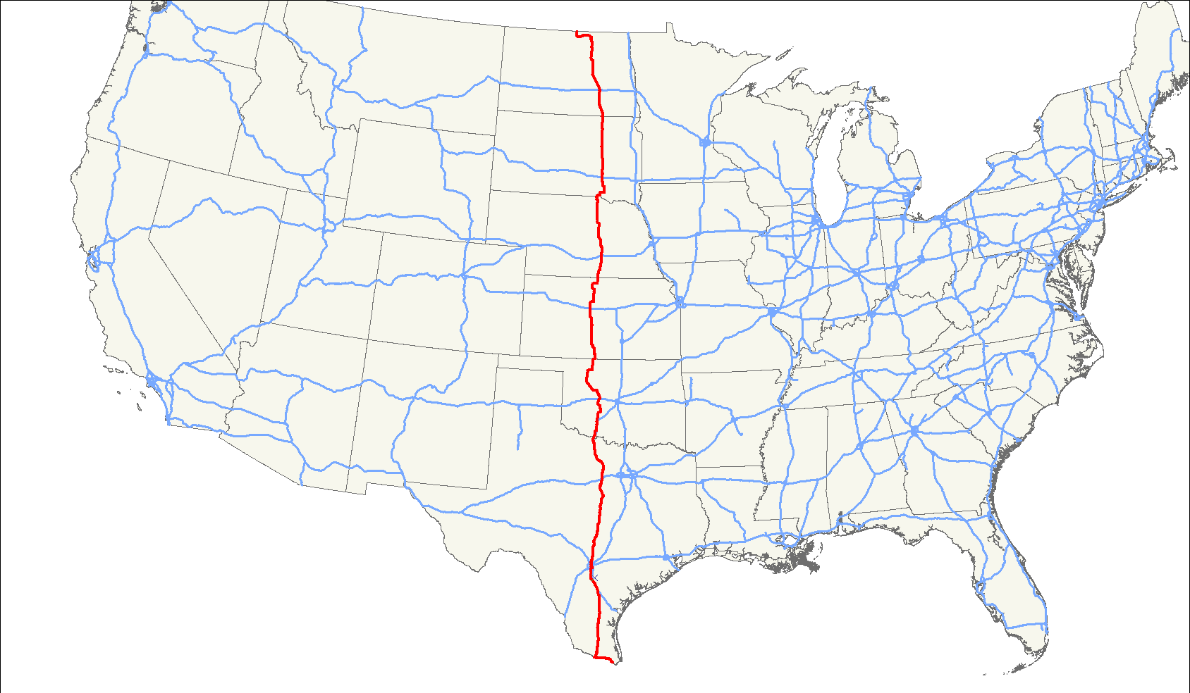
length_mi=1872
length_ref=Droz, Robert V. [http://www.us-highways.com/us1830.htm#16 Sequential List with Termini and Lengths in Miles] . "US Highways from US 1 to (US 830)". URL accessed11 August 2006 .]
length_km=3013
yrcom=1931Droz, Robert V. [http://www.us-highways.com/us1.htm#US_281 North - South US Highways with daughter routes, From US 1 to US 101] . "US Highways from US 1 to (US 830)". URL accessed11 August 2006 .]
direction_a=South
from=
junction=
direction_b=North
to= border
spur_of=81U.S. Highway 281 is a north-south
United States highway . It is 1,872 miles (3,013 km) long and is currently the longest continuous three-digit U.S. Route.The highway's northern terminus is at the
International Peace Garden , north ofDunseith, North Dakota , at the Canadian border, where it continues as Highway 10. The route between Dunseith and the border is shared withNorth Dakota Highway 3 . The southern terminus of US 281 is inBrownsville, Texas , just short of the Mexican border.Route description
Texas
Starting at an intersection with Business US 77 and SH 48 about 2 miles from the Mexico border, US 281 travels along the border through the Rio Grande Valley, turning north at Hidalgo, travelling through many small towns, alternating as a divided highway and main street, until joining I-37. It splits with I-37 and travels through Pleasanton, travelling north to
San Antonio . In San Antonio, US 281 overlaps I-410 on the south side of the city until the interchange with I-37. US 281 and I-37 then overlap north into downtown San Antonio until I-37 ends at I-35. US 281 continues north from downtown San Antonio as a freeway, intersecting I-410 again on the north side of the city, with access to theSan Antonio International Airport . A project to construct a stack interchange at I-410 (the "San Antonio Web"cite news |first=Patrick |last=Driscoll |authorlink= |coauthors= |title=Now there's a name for it |url=http://blogs.mysanantonio.com/weblogs/traffic/archives/2006/01/missing_interch.html |work=San Antonio Express-News |publisher= |date=2006-01-16 |accessdate=2008-06-20 ] ) was completed June 9, 2008;cite news |first=Patrick |last=Driscoll |authorlink= |coauthors= |title=U.S. 281/Loop 410 interchange ramps are complete |url=http://www.mysanantonio.com/news/metro/stories/MYSA061008.1A.Lastramps.389a3a1.html |work=San Antonio Express-News |publisher= |date=2008-06-10 |accessdate=2008-06-20 ] formerly there was no direct access between the two freeways and surface streets were required travel between the freeways. North of San Antonio, US 281 is not a freeway and forms theMain Street of Blanco. It overlaps US 290 south of Johnson City. US 290 continues toward Austin, so US 281 and US 290 between San Antonio and Austin are available as a scenic and less congested alternate to I-35.North of San Antonio, US 281 continues through central and north-central Texas, passing through many towns, including Stephenville, Mineral Wells and Jacksboro before reaching Wichita Falls, where the highway begins a concurrency with I-44 north across the Red River into
Oklahoma .Oklahoma
US-281 enters the state of Oklahoma at the Red River bridge north of
Burkburnett, Texas on a route concurrent with Interstate 44 starting in Wichita Falls. About 6 miles north of the Red River, US-281 leaves I-44 at Randlett, Oklahoma and follows a two-lane roadway paralleling I-44, which becomes the Wichita Falls-Lawton section of theH.E. Bailey Turnpike , from Randlett to a point 6 miles south of Lawton.Through the Lawton/Fort Sill metropolitan area, US-281 again overlaps a free section of I-44, while the former US-281 alignment through the city of Lawton is designated as Business US-281 between I-44 exits 34 and 39B. About 8 miles north of downtown Lawton, US-281 departs from I-44 to continue north through the cities of Apache, Anadarko, Gracemont, Binger and Hinton. About 2 miles north of its junction with Interstate 40 near Hinton, US-281 crosses a 1930's-vintage 38-span steel pony truss bridge over the South Canadian River that served traffic of the former east-west US-66 before that highway was superseded by I-40 in the 1960s. A four-mile section of US-281's paving from north of I-40 to a point south of Geary is the original 18-foot concrete surface of Route 66.
Through central and northern Oklahoma, US-281 then proceeds through the cities of Geary, Watonga, Seiling and Alva. The highway crosses the Kansas state line about 14 miles north of Alva at Hardtner, Kansas.
Kansas
Passing largely through sparsely populated areas of central Kansas, US-281 enters the state at Hardtner in Barber County and passes through Medicine Lodge, Pratt,
St. John, Kansas and Great Bend, the only city along the route in Kansas which has more than 7,000 people. Along its venture through southern Kansas, US-281 intersects several major east-west routes: first US-54 and US-400, which heads east to Wichita and west to Dodge City, Garden City and Liberal; US-50, which veers east to Hutchinson and west to Garden City; and US-56, heading to Dodge City westbound and Emporia and Overland Park eastbound.
St. JohnFollowing a four-mile concurrency with K-4 near Hoisington, the highway intersects Interstate 70 at Russell before joining K-18 near Paradise for an eight-mile concurrency.
The two highways split at Luray, and US-281 turns north into Osborne County, passing through the town of Osborne before joining US-24 and K-9 for another concurrency. US-281 joins US-36 at Smith Center, turning east before the two highways split, with US-281 turning north for its final stretch in the state, passing through Lebanon. All sections of US-281 in Kansas are two-lane, with portions passing through the downtown areas of Pratt and Hoisington still overlaid with bricks.
Nebraska
U.S. 281 enters Nebraska south of Red Cloud and meets
U.S. Route 136 there. It continues north to Hastings and meetsU.S. Route 6 andU.S. Route 34 . Between Hastings and Grand Island, U.S. 281 overlaps U.S. 34 and is designated as theTom Osborne Expressway after the former Nebraska Cornhuskers football coach and U.S. Representative. At Grand Island, U.S. 281 intersectsInterstate 80 , loses U.S. 34 and intersectsU.S. Route 30 . U.S. 281 continues north of Grand Island to St. Libory as expressway. From there northward, U.S. 281 is a two-lane undivided highway passing mostly through unpopulated areas, with the exception of the regional trade center O'Neill, where it junctionsU.S. Route 20 andU.S. Route 275 . U.S. 281 exits the state north of Spencer.outh Dakota
U.S. Highway 281 enters South Dakota in Gregory County. Just north of the South Dakota-Nebraska border, it is cosigned with U.S. 18. It crosses the
Missouri River atFort Randall Dam . Just south of Armour, U.S. 18 leaves the U.S. 281 alignment. North of Armour, U.S. 281 makes a short jaunt west onSouth Dakota Highway 44 , then continues north. U.S. 281 andInterstate 90 intersect at Plankinton. West of Huron, U.S. 14 is cosigned with U.S. 281 for 7 miles. U.S. 281 becomes an expressway atSouth Dakota Highway 20 . This expressway continues through Aberdeen to a point near Westport.South Dakota Highway 10 is cosigned with U.S. 281 for 3 miles near Barnard. It exits the state north of Frederick.U.S. 281 was recently realigned in the city of Aberdeen. A bypass was built that travels on the west side of Aberdeen, and the U.S. 281 designation was moved onto that new roadway. It runs north from U.S. Highway 12 and connects with the old alignment south of 24th Avenue Northeast.
The South Dakota section of U.S. 281, with the exception of concurrencies with
U.S. 18 andU.S. 14 , is defined at South Dakota Codified Laws § 31-4-229. [ [http://legis.state.sd.us/statutes/DisplayStatute.aspx?Type=Statute&Statute=31-4-229 South Dakota Codified Laws ] ]North Dakota
In North Dakota, U.S. 281 is a major north-south artery. It enters south of Ellendale and intersects
Interstate 94 andU.S. Route 52 atJamestown, ND . 281 and 52 remain paired together to Carrington. From there, U.S. 281 continues northward through Sheyenne. Ten miles north of Sheyenne the highway curves in order to go around Devil's Lake, and then continues toMinnewaukan, North Dakota . From there it goes toNorth Dakota Highway 5 at Rocklake. U.S. 281 follows ND 5 westward to Dunseith, where 281 turns northward to its end at the Canadian border in theInternational Peace Garden . The northernmost section of U.S. 281 passes through North Dakota's Turtle Mountains. Recently, 281 was rebuilt nearMinnewaukan, North Dakota to accommodate flooding close to the city.Major intersections
US 281 intersects with the following Interstate Highways:
*Interstate 94 inJamestown, North Dakota
*Interstate 90 nearPlankinton, South Dakota
*Interstate 80 inGrand Island, Nebraska
* Interstate 70 inRussell, Kansas
* Interstate 40 inHinton, Oklahoma
*Interstate 44 betweenWichita Falls, Texas and a point nearMedicine Park, Oklahoma (co-signed route)
* Interstate 20 south ofMineral Wells, Texas
* Interstates 10, 410, 35, and 37 inSan Antonio, Texas
* Interstate 37 between Pleasanton and Three Rivers,Texas (shared route)ee also
Related routes
*
U.S. Highway 81
*U.S. Highway 181 External links
* [http://www.broermapsonline.org/members/NorthAmerica/UnitedStates/NorthCentral/NorthDakota/unitedstates1926ra_041.html |1926 Map of North Dakota U.S. 281 Route (Former ND Highway 4)]
References
###@@@KEYEND@@@###
Wikimedia Foundation. 2010.