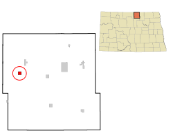
- Dunseith, North Dakota
-
Dunseith, North Dakota — City — Location of Dunseith, North Dakota Coordinates: 48°48′49″N 100°3′42″W / 48.81361°N 100.06167°WCoordinates: 48°48′49″N 100°3′42″W / 48.81361°N 100.06167°W Country United States State North Dakota County Rolette Named for Jeannette Dunseith Eaton Area - Total 1.0 sq mi (2.6 km2) - Land 1.0 sq mi (2.6 km2) - Water 0.0 sq mi (0.0 km2) Elevation 1,706 ft (520 m) Population (2010)[1] - Total 773 - Density 729.2/sq mi (281.5/km2) Time zone Central (CST) (UTC-6) - Summer (DST) CDT (UTC-5) ZIP code 58329 Area code(s) 701 FIPS code 38-21020[2] GNIS feature ID 1028750[3] Dunseith (pronunciation: /dʌnˈsiːθ/ dun-seeth) is a city in Rolette County, North Dakota in the United States. The population was 773 at the 2010 census.[1] Dunseith was founded in 1884. The town is named for Jeannette Dunseith Eaton, who was the mother of the town's founder William Eaton.
Contents
History
Dunseith is best known for its proximity to the International Peace Garden. Dùnsìth is a Gaelic word meaning "City of Peace,"[4] from dùn (English: fortress) and sìth (English: peace).[5] The port of entry at the Peace Garden is one of three 24-hour ports in North Dakota (the others being Portal and Pembina).
Geography
According to the United States Census Bureau, the city has a total area of 1.0 square mile (2.6 km2), all of it land.
Demographics
Historical populations Census Pop. %± 1910 473 — 1920 374 −20.9% 1930 484 29.4% 1940 719 48.6% 1950 713 −0.8% 1960 1,017 42.6% 1970 811 −20.3% 1980 625 −22.9% 1990 723 15.7% 2000 739 2.2% 2010 773 4.6% U.S. Decennial Census As of the census[2] of 2000, there were 739 people, 253 households, and 178 families residing in the city. The population density was 729.2 people per square mile (282.5/km²). There were 282 housing units at an average density of 278.2 per square mile (107.8/km²). The racial makeup of the city was 24.76% White, 0.27% African American, 71.04% Native American, 0.14% Asian, 0.14% from other races, and 3.65% from two or more races. Hispanic or Latino of any race were 0.27% of the population.
There were 253 households out of which 44.3% had children under the age of 18 living with them, 31.6% were married couples living together, 32.4% had a female householder with no husband present, and 29.6% were non-families. 26.5% of all households were made up of individuals and 9.5% had someone living alone who was 65 years of age or older. The average household size was 2.74 and the average family size was 3.23.
In the city the population was spread out with 35.2% under the age of 18, 11.1% from 18 to 24, 23.8% from 25 to 44, 14.5% from 45 to 64, and 15.4% who were 65 years of age or older. The median age was 28 years. For every 100 females there were 90.5 males. For every 100 females age 18 and over, there were 80.1 males.
The median income for a household in the city was $17,917, and the median income for a family was $19,531. Males had a median income of $21,042 versus $20,250 for females. The per capita income for the city was $9,478. About 40.0% of families and 36.5% of the population were below the poverty line, including 48.7% of those under age 18 and 24.6% of those age 65 or over.
References
- ^ a b "2010 Census Redistricting Data (Public Law 94-171) Summary File". American FactFinder. United States Census Bureau. http://factfinder2.census.gov/faces/tableservices/jsf/pages/productview.xhtml?pid=DEC_10_PL_GCTPL2.ST13&prodType=table. Retrieved 2 May 2011.
- ^ a b "American FactFinder". United States Census Bureau. http://factfinder.census.gov. Retrieved 2008-01-31.
- ^ "US Board on Geographic Names". United States Geological Survey. 2007-10-25. http://geonames.usgs.gov. Retrieved 2008-01-31.
- ^ Wick, Douglas A. (1988). North Dakota Place Names. Bismarck, North Dakota: Hedemarken Collectibles. pp. 52. ISBN 0-9620968-0-6. OCLC 191277027.
- ^ "Scottish Gaelic dictionary". Lexiglos.com. 2009. http://www.lexilogos.com/english/gaelic_scottish_dictionary.htm. Retrieved 2009-10-19.
Municipalities and communities of Rolette County, North Dakota County seat: Rolla Cities Townships Holmes | Kohlmeier | Maryville | Shell Valley | South Valley
CDPs Belcourt | East Dunseith | Green Acres | Shell Valley
Unorganized
territoriesEast Rolette | North Rolette | South Rolette | Turtle Mountain
Unincorporated
communityAgate | Carpenter | Fonda | Kelvin | Nanson | San Haven | Thorne
Categories:- Cities in North Dakota
- Populated places in Rolette County, North Dakota
- Populated places in North Dakota with Native American majority populations
- Populated places established in 1884
Wikimedia Foundation. 2010.


