- O'Neill, Nebraska
-
O'Neill, Nebraska — City — Shamrock painted on pavement at 4th and Douglas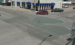 Location of O'Neill, Nebraska
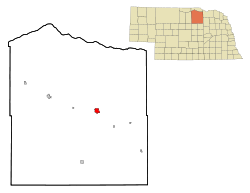
Coordinates: 42°27′39″N 98°38′49″W / 42.46083°N 98.64694°WCoordinates: 42°27′39″N 98°38′49″W / 42.46083°N 98.64694°W Country United States State Nebraska County Holt Area – Total 2.4 sq mi (6.1 km2) – Land 2.4 sq mi (6.1 km2) – Water 0.0 sq mi (0.0 km2) Elevation 1,988 ft (606 m) Population (2000) – Total 3,733 – Density 1,580.7/sq mi (610.3/km2) Time zone Central (CST) (UTC-6) – Summer (DST) CDT (UTC-5) ZIP code 68763 Area code(s) 402 FIPS code 31-37105[1] GNIS feature ID 0831786[2] O'Neill is a city in Holt County, Nebraska, United States. The population was 3,733 at the 2000 census. It is the county seat of Holt County[3].
Contents
Geography
O'Neill is located at 42°27′39″N 98°38′49″W / 42.46083°N 98.64694°W (42.460753, -98.647016)[4].
According to the United States Census Bureau, the city has a total area of 2.4 square miles (6.2 km2), all of it land.
O'Neill is the official Irish capital of Nebraska.[5] Cattle, potatoes, tomatoes, soybeans and corn are the major products produced near this town.[citation needed]
Transportation
Until 1992, O'Neill was served by the Chicago and North Western Transportation Company. The line, known as the "Cowboy Line", ran from Norfolk, Nebraska to Chadron. The line has since been removed and "railbanked"; it is now part of the Cowboy Trail, the longest bike trail in Nebraska.[6]
O'Neill is also served by a former Chicago, Burlington & Quincy branch line from the Sioux City, Iowa vicinity. This line is now operated as the Nebraska Northeastern Railway.
The highways which go through O'Neill include U.S. Highway 20, U.S. Highway 275, and U.S. Highway 281.
Demographics
As of the census[1] of 2000, there were 3,733 people, 1,554 households, and 988 families residing in the city. The population density was 1,580.7 people per square mile (610.7/km²). There were 1,740 housing units at an average density of 736.8 per square mile (284.7/km²). The racial makeup of the city was 98.53% White, 0.03% African American, 0.43% Native American, 0.16% Asian, 0.40% from other races, and 0.46% from two or more races. Hispanic or Latino of any race were 1.18% of the population.
There were 1,554 households out of which 30.4% had children under the age of 18 living with them, 54.0% were married couples living together, 7.7% had a female householder with no husband present, and 36.4% were non-families. 33.8% of all households were made up of individuals and 17.8% had someone living alone who was 65 years of age or older. The average household size was 2.33 and the average family size was 3.01.
In the city the population was spread out with 26.7% under the age of 18, 5.7% from 18 to 24, 24.8% from 25 to 44, 20.4% from 45 to 64, and 22.3% who were 65 years of age or older. The median age was 40 years. For every 100 females there were 84.1 males. For every 100 females age 18 and over, there were 80.9 males.
The median income for a household in the city was $30,815, and the median income for a family was $40,063. Males had a median income of $28,614 versus $18,627 for females. The per capita income for the city was $15,998. About 5.0% of families and 8.5% of the population were below the poverty line, including 3.4% of those under age 18 and 12.3% of those age 65 or over.
Community Information
O'Neill is named after its founder, John O'Neill, an Irish born American who brought settlers to Nebraska during the 1870s. Born in Clontibret, Co Monaghan, Ireland, he had previously served as a Colonel in the United States Army before resigning his commission and becoming active in the Fenian Brotherhood. It was this involvement in radical Irish politics that led him to become involved in the abortive Fenian raids of 1866, 1870, and 1871. Following a short prison term for his involvement in the 1871 raid, O'Neill became a land speculator and promoter of Irish settlement in Nebraska. He died in January 1878.
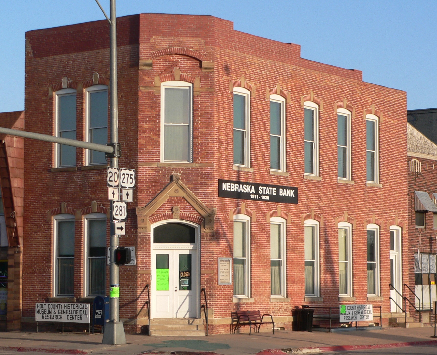
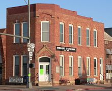 The old Nebraska State Bank building is now the Holt County Historical Museum. Moses Kinkaid's office, now restored, occupied the second floor of the building.
Father Edward Flanagan, who went on to establish Boys Town, first served as a Catholic priest at St. Patrick's Catholic Church in O'Neill. For now, O'Neill houses the world's largest permanent shamrock. Made of colored concrete, it was installed in the main intersection of 4th & Douglas in 2000. Saint Patrick's Day and the Summerfest in July are the town's main celebrations.
The local radio station is KBRX, 102.9FM, 1350AM. Both bands play country music most of the time, though the AM band also has blocks of polka ("milking music") in the morning and oldies in the evening. The Holt County Independent is O'Neill's local newspaper.
O'Neill has two high schools, O'Neill High School and St. Mary's.
Notable natives and residents
- Moses Kinkaid, U.S. Representative from Nebraska and sponsor of the Kinkaid Act
- Frank Leahy, American college football coach
- U.S. Senator Thomas Kearns, Utah Mining magnate and owner of Salt Lake Tribune, an O'Neill native
References
- ^ a b "American FactFinder". United States Census Bureau. http://factfinder.census.gov. Retrieved 2008-01-31.
- ^ "US Board on Geographic Names". United States Geological Survey. 2007-10-25. http://geonames.usgs.gov. Retrieved 2008-01-31.
- ^ "Find a County". National Association of Counties. http://www.naco.org/Counties/Pages/FindACounty.aspx. Retrieved 2011-06-07.
- ^ "US Gazetteer files: 2010, 2000, and 1990". United States Census Bureau. 2011-02-12. http://www.census.gov/geo/www/gazetteer/gazette.html. Retrieved 2011-04-23.
- ^ "O'Neill, Irish Capital of Nebraska". Nebraska State Historical Society. Retrieved 2010-04-19.
- ^ Nebraska Game and Parks Commission, "The Cowboy Trail", Retrieved 2010-03-03.
Municipalities and communities of Holt County, Nebraska Cities Atkinson | O'Neill
Villages Townships Antelope | Atkinson | Belle | Chambers | Cleveland | Coleman | Conley | Deloit | Dustin | Emmet | Ewing | Fairview | Francis | Golden | Grattan | Green Valley | Holt Creek | Inman | Iowa | Josie | Lake | McClure | Paddock | Pleasant View | Rock Falls | Sand Creek | Saratoga | Scott | Shamrock | Sheridan | Shields | Steel Creek | Stuart | Swan | Verdigris | Willowdale | Wyoming
Unincorporated
communityCategories:- Cities in Nebraska
- Populated places in Holt County, Nebraska
- Irish-American neighborhoods
- County seats in Nebraska


Wikimedia Foundation. 2010.