- Nebraska Public Power District
-
"NPPD" redirects here. For other uses, see NPPD (disambiguation).
Nebraska Public Power District (NPPD) is the largest electric utility in the state of Nebraska, serving all or parts of 91 (of 93) counties. It was formed on January 1, 1970, when Consumers Public Power District, Platte Valley Public Power and Irrigation District (PVPPID) and Nebraska Public Power System merged to become Nebraska Public Power District. NPPD's predecessors were created through the efforts of the Nebraska legislature and financial agent Guy L. Myers as part of a system where all the investor-owned utilities operating in the state of Nebraska (Nebraska Power Co., Central Power Co., Southern Nebraska Power Co., et al.) were condemned and their properties turned over to 'public power districts' being created at the time (early 1940s). NPPD is a public corporation and political subdivision of the state of Nebraska. The utility is governed by an 11-member Board of Directors, who are popularly elected from NPPD's chartered territory.
NPPD's revenue is mainly derived from wholesale power supply agreements with 52 cities/villages and 25 rural public power districts and rural cooperatives. NPPD also serves about 79 communities directly at the retail level. Over 5,000 miles (8,000 km) of transmission lines make up the NPPD electrical grid system, which delivers power to about one million customers.
NPPD's corporate headquarters are located in Columbus, Nebraska.
Contents
Generating facilities
Nuclear
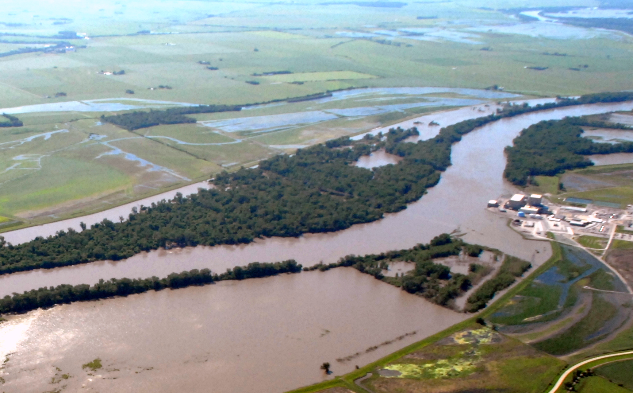
Cooper Nuclear Station — Brownville
 Cooper on June 15, 2011 during the 2011 Missouri River Floods
Coal
Canaday — Lexington
Gerald Gentleman Station — Sutherland
Sheldon — Hallam
Plant Information
Construction of Sheldon Station began in 1958--first as a combined nuclear and conventional facility. It was the pioneer sodium graphite nuclear power plant in the nation. The nuclear portion of the plant began operating early in 1963 and was at full power by July, 1963. However, this portion of the facility was ordered decommissioned by the former Atomic Energy Commission (AEC), now the Nuclear Regulatory Commission, in 1964.
The AEC, which built the atomic plant, said it had garnered all the information it wanted about the sodium graphite plant and the former Consumers Public Power District, which cooperated in the project, said it didn't care to operate the nuclear portion of the facility any longer. The decommissioning work was done under the direction of Consumer's employees. It was up to the AEC to determine what to do with the components.
Some of the nuclear equipment was shipped to other nuclear plants for reuse while other equipment was stored in Idaho and Washington for future AEC use. What couldn't be moved was buried within mammoth "burial vaults" of concrete and then the "leftovers," including the reactor core, were sealed below the surface of the earth.
In addition to the nuclear portion of the plant, Sheldon Station has produced electricity for the Nebraska grid system since 1961 from a conventional coal and gas fired boiler. As the nuclear facility was being deactivated, a second generator was being installed and this was followed by a second conventional boiler. By July, 1968, all construction was completed and the plant was operating at its full 225,000 kilowatt capacity with two power generating units.
Each of the two boilers supplies steam to drive its own electric generator. The plant's water supply comes from its own deep wells and the discharge of water from the plant is watched and carefully controlled to assure that it is not detrimental to the environment. To conserve water, cooling towers are used to dissipate the waste heat from the steam condenser thus permitting the water to be recycled.
Major modifications were completed in 1974 at a cost of $4.2 million to accommodate switching the facility from using natural gas as the primary fuel to low sulfur coal. Involved was the construction and installation of enlarged coal storage and handling facilities necessary in making the transition to using only low sulfur coal.
In addition, the installation of electrostatic precipitators to bring the facility into conformance with clean air requirements resulted in an expenditure of some $12.2 million. The precipitator on one stack was completed in December, 1975, and on the other in July, 1976. Installation of equipment to meet regulations on the chemical discharge of water had a price tag of some $7 million.
In a concentrated effort to eliminate concern over the plant's effect on the environment, NPPD states flatly and simply that Sheldon Station will meet all federal and state air pollution and water quality control standards and regulations.
The Location
Sheldon Station is located 17 miles south and five miles west of Lincoln or one mile north of Hallam in Lancaster County, Nebraska.
The switchyard is located west of the plant buildings and the coal stockpile is located north of the buildings.
Power generated is distributed throughout Nebraska via two substations. The Sheldon 115 KV substation has connections to Lincoln, Mark T. Moore substation, Crete, Norris Public Power District, Sterling, Beatrice, and Firth. The Mark T. Moore 345 KV substation connects to Lincoln, McCool Junction, Pauline, Cooper Nuclear Station, and Wagener (LES). From these points the plant has interconnections to the entire United States.
Unit Specifications
Unit 1 (Coal Fired)
Generating Capacity 105,000 Kilowatts (net) Physical Size 135 feet high - 165 feet wide - 350 feet long Chimney Height 176 feet Cooling Water Circulating Capacity 60,000 gal. per minutes Coal Capacity at Full Capacity 65 tons per hour Boiler Manufacturer Babcock & Wilcox Ground Breaking June 28, 1958 Commercial In-Service Date July 1961 Unit 2 (Coal Fired)
Generating Capacity 120,000 kilowatts (net) Physical Size 135 feet high - 143 feet wide - 350 feet long Chimney Height 176 feet Cooling Water Circulating Capacity 60,000 gal. per minutes Coal Capacity at Full Capacity 74 tons per hour Boiler Manufacturer Babcock & Wilcox Ground Breaking June 28, 1958 Commercial In-Service Date July 1968 Combined Units
Coal Source Wyoming Powder River Basin Construction Cost $38,000,000* Type of Coal Subbituminous, Low Sulfur Western (Wyoming) Operating Personnel 95 - Doesn't include $23,400,000 which was spent for environmental improvement in the mid 1970's.
The Name
C. C. Sheldon was a nationally known figure in public power and conservation of soil and water resources whose constructive influence extended into many spheres of public, business and religious life.
He was born May 29, 1871, at Clifton, Ill., and moved with his family at a young age to Columbus, Neb. Throughout his life, Mr. Sheldon maintained an active interest in banking, other businesses and agriculture and was devoted to the importance of resource conservation.
Mr. Sheldon was one of the pioneers in the development of hydroelectric power from the Loup River. He was one of the organizers of the Loup River Public Power District in 1933, its first treasurer and a director. His many services included extensive efforts in obtaining passage of the Enabling Act for the creation of public power districts in the 1933 Nebraska Legislature.
He played a leading role in the establishment of Consumers Public Power District, a predecessor of Nebraska Public Power District, and was an original director and first treasurer.
Mr. Sheldon died January 10, 1964, at Columbus, at the age of 92.
Combined-cycle
Beatrice Power Station — Beatrice
The Beatrice Power Station received provisional acceptance for commercial operation on January 7, 2005. An important part of NPPD's long-term energy supply strategy, the Beatrice Power Station was primarily built for three reasons: to act as a hedge against an unforeseen extended outage occurring at one of NPPD's major power plants; to help meet future electric load growth in NPPD's native service area; and to give NPPD's electric power generation added fuel diversity.
The Station uses two combustion turbines and one steam turbine in tandem, called "combined-cycle," to achieve a greater percentage of energy output efficiency. This configuration allows for greater flexibility in meeting load demands. For instance, the plant can run with one or two combustion turbine(s); one combustion and the steam turbine or all three units together. Beatrice Power Station can generate 250 megawatts of power.
Original project costs were estimated/budgeted at $241 million. Project costs were re-baselined in the spring of 2003 and reduced to $209 million. Procurement changes to some design configurations resulted in a final cost of less than $200 million.
The site for the new plant is in the Beatrice area of Gage County/Beatrice. This site was selected because of its access to major natural gas pipelines and existing electric transmission infrastructure.
Site selection criteria included access to major natural gas pipelines, existing electric transmission infrastructure, water supply and wastewater discharge. Minimization of impact on neighbors, proximity to roads, flood plain, airport and other parameters were considered in the site screening process.
Plant personnel include 14 positions.
In addition, NPPD operates two wind generation facilities, nine hydroelectric facilities, nine diesel plants and three peaking units.
NPPD also purchases electricity from the Western Area Power Administration, which is operated by the United States Department of Energy.
Irrigation & Recreation
NPPD also operates the intricate network of irrigation canals, dams and reservoirs along a 150-mile (240 km) stretch of the Platte River which help power its hydro plants. In addition to the essential role the water plays in irrigating farmland and generating electricity in the area, the reservoir system provides fishing, hunting and boating opportunities for all Nebraskans.
Lake Maloney
Lake Maloney is, like, totally rad. It is located along Highway 83, five miles (8 km) south of the Interstate 80 exit at North Platte, Neb. Lake Maloney is used to regulate the flow of water for generating electricity at NPPD's nearby North Platte Hydro facility. The 1,650-acre (6.7 km2) reservoir is a popular place for fishing, skiing and boating. A handicap-accessible fishing pier, fish-cleaning station and 57 camping pads with electrical hookups are available at the lake's Inlet Recreation Area.
Lake Maloney's Outlet Recreation Area has camp sites, a trailer dump station, two boat ramp/docks, a fish-cleaning station and a shower house. Primitive camp sites are also available at several locations around the lake, and an 18-hole golf course is nearby. Entry to the lake requires a day or season pass from the Nebraska Game and Parks Commission. Camping fees are posted.
Lake Ogallala/Sutherland Supply Canal
Lake Ogallala and the Sutherland Supply Canal are among the top trout fisheries in the state. The area is also one of the best places in the nation for viewing a wide variety of native and migratory birds, including bald eagles.
The lake is formed by the Keystone Dam on the North Platte River. Canal roads can be accessed east from Highway 61 or north from U.S. 30 at Roscoe and Paxton. Because of steep banks and swift water, no wading, boating or watercraft are permitted in the canal. Anglers fishing from the banks are recommended to wear life jackets. Emergency buoys with ropes are location along the canal. This is a day-us area; no overnight camping is allowed.
Sutherland Reservoir
The Sutherland Reservoir is a 3,000-acre (12 km2) lake located three miles (5 km) south of the Interstate 80 Exit at Sutherland, Neb. NPPD owns and manages the Sutherland Reservoir, part of its hydropower system. Nebraska Game and Parks Commission (NGPC) oversees most of the recreation areas at the lake. A day or season pass is required for entry into NGPC areas.
Primitive campsites are located on the east and west sides of the lake, while a private camping area with electrical hook-ups and a nine-hole golf course are located along the north shore. Four boat launching ramps and two swimming areas are available. NPPD maintains a roost and perch tree protection program for eagles and, during the winter months, bird watchers can observe numerous wintering American Bald Eagles.
North Platte Trail
In North Platte, the city's riding and hiking path continues on the south side of town along NPPD's North Platte Hydro tailrace canal. Trail users travel under Interstate 80 on a low-water bridge along the canal. Hikers and bikers pass along the grass and gravel canal maintenance road to State Farm Road where the route continues west. From the bridge, trail users receive a fine view of the North Platte Hydro. Fishing is allowed north of the bridge, but not immediately downstream of the North Platte Hydro. Boaters and swimmers are restricted from the tailrace canal.
Kearney Canal Trail
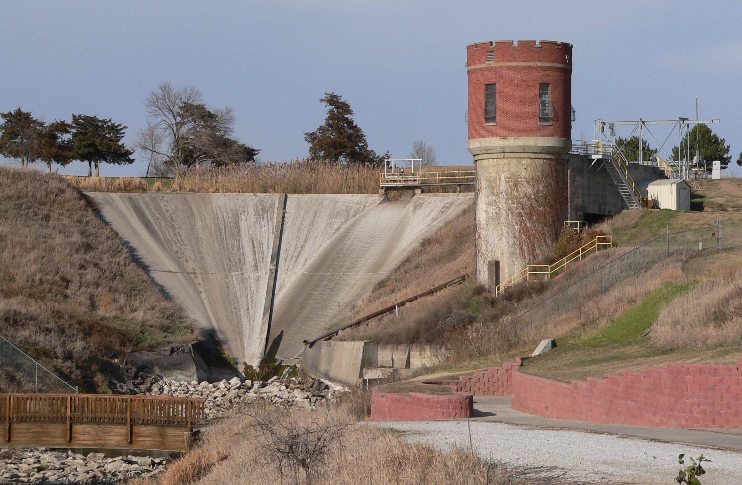
 Kearney Dam and hydro plant
The City of Kearney and Buffalo County Parks and Recreation Department constructed an 8-foot (2.4 m)-wide concrete trail along NPPD's Kearney Canal in 1996. The 2.6-mile (4.2 km) scenic corridor is a gradual downhill grade from Cottonmill Park to the University of Nebraska at Kearney campus. The 16-mile (26 km)-long canal was built in the 1880s to divert Platte River water for irrigation and electrical generation. Cottonmill Lake once served as a reservoir for a cotton mill and now is a city park. The Kearney Dam & Hydro date to 1889. The 1.485-megawatt hydro-generator in the turret-looking tower was refurbished by NPPD in 1996. Access to NPPD's dam and hydro areas near the trail is restricted with no swimming or boating allowed.
Districts Served by NPPD
- Burt County PPD
- Butler PPD
- Cedar-Knox PPD
- Cuming County PPD
- Custer PPD
- Dawson PPD
- Elkhorn RPPD
- Howard-Greeley RPPD
- KBR RPPD
- Loup PPD
- Loup Valleys RPPD
- McCook PPD
- Niobrara Valley EMC
- Norris PPD
- North Central PPD
- Northeast NE PPD
- Perennial PPD
- Polk County PPD
- Seward County PPD
- South Central PPD
- Southern PD
- Southwest PPD
- Stanton County PPD
- Twin Valleys PPD
Wholesale Communities Served by NPPD
- Arapahoe
- Auburn
- Battle Creek
- Beatrice
- Bradshaw
- Brainard
- Central City
- Chester
- Cozad
- Davenport
- David City
- Deshler
- DeWitt
- Dorchester
- Edgar
- Fairmont
- Friend
- Giltner
- Gothenburg
- Hampton
- Hebron
- Hemingford
- Hildreth
- Holdrege
- Lexington
- Lodgepole
- Lyons
- Madison
- Minden
- Neligh
- Nelson
- North Platte
- Ord
- Polk
- Prague
- Randolph
- Scribner
- Seward
- Snyder
- South Sioux City
- Summerfield, KS
- Superior
- Sutton
- Valentine
- Wahoo
- Wakefield
- Walthill
- Wauneta
- Wayne
- Webber, KS
- Wilcox
- Wymore
Retail Communities Served by NPPD
- Ainsworth
- Alma
- Anoka
- Ashton
- Atkinson
- Aurora
- Barada
- Bassett
- Big Springs
- Bloomfield
- Brandon
- Bristow
- Broadwater
- Brule
- Burchard
- Butte
- Chadron
- Clinton
- Crab Orchard
- Craig
- Crawford
- Creighton
- Crystal Lake
- Dakota City
- Dawson
- DuBois
- Elm Creek
- Elsie
- Emmet
- Fort Robinson
- Geneva
- Gibbon
- Gordon
- Hartington
- Hay Springs
- Homer
- Humboldt
- Inman
- Kearney
- Lewellen
- Lewiston
- Lisco
- Long Pine
- Loup City
- Lynch
- Madrid
- McCook
- McGrew
- Meadow Grove
- Melbeta
- Merriman
- Milford
- Minatare
- Murray
- Mynard
- Nehawka
- Norfolk
- Northport
- Oakdale
- Oakland
- Odessa
- Ogallala
- Oglala Sioux
- O'Neill
- Oshkosh
- Pawnee City
- Pine Ridge
- Plattsmouth
- Ravenna
- Rushville
- St. Mary
- Scottsbluff
- Shelton
- Shubert
- Steinauer
- Stella
- Sterling
- Sutherland
- Table Rock
- Tekamah
- Terrytown
- Tilden
- Union
- Venango
- Verdon
- White Clay
- Whitney
- Winnebago
- York
External links
Categories:- Nuclear power companies of the United States
- Power districts in Nebraska
- Electric generation and transmission cooperatives in the United States
Wikimedia Foundation. 2010.