- Nevada County, Arkansas
-
Nevada County, Arkansas 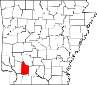
Location in the state of Arkansas
Arkansas's location in the U.S.Founded March 20, 1871 Seat Prescott Area
- Total
- Land
- Water
620.78 sq mi (1,608 km²)
619.95 sq mi (1,606 km²)
0.83 sq mi (2 km²), 0.13%Population
- (2010)
- Density
8,997
15/sq mi (5.6/km²)Nevada County is a county located in the U.S. state of Arkansas. As of 2010, the population was 8,997. The county seat is Prescott.[1] Nevada County is Arkansas's 63rd county, formed on March 20, 1871, and named for the State of Nevada due to the perceived similarity between their physical shapes; the Arkansas county's shape roughly follows the same outline as the state's boundary when inverted. Contrasting with the name of the U.S. state, the local pronunciation for the southwestern Arkansas county is "nuh-VAY-duh". It is an alcohol prohibition or dry county.
Nevada County is part of the Hope Micropolitan Statistical Area.
Dorcheat Bayou, a 122-mile stream, begins in Nevada County. It flows south into Columbia County and then Webster Parish, Louisiana, and empties into Lake Bistineau. In the 19th century, the bayou was navigable for three to six months by steamboat from Bistineau to Minden. It is now popular for fishing and natural beauty.[2]
Contents
Geography
According to the 2000 census, the county has a total area of 620.78 square miles (1,607.8 km2), of which 619.95 square miles (1,605.7 km2) (or 99.87%) is land and 0.83 square miles (2.1 km2) (or 0.13%) is water.[3] Nevada County is alternately considered as part of the greater regions of South Arkansas or Southwest Arkansas.
Major highways
 Interstate 30
 U.S. Highway 67
 U.S. Highway 278
 U.S. Highway 371
 Highway 4
 Highway 19
 Highway 24
 Highway 32
 Highway 51
 Highway 53
Adjacent counties
- Clark County (northeast)
- Ouachita County (east)
- Columbia County (south)
- Lafayette County (southwest)
- Hempstead County (west)
- Pike County (northwest)
Demographics
Historical populations Census Pop. %± 1880 12,959 — 1890 14,832 14.5% 1900 16,609 12.0% 1910 19,344 16.5% 1920 21,934 13.4% 1930 20,407 −7.0% 1940 19,869 −2.6% 1950 14,781 −25.6% 1960 10,700 −27.6% 1970 10,111 −5.5% 1980 11,097 9.8% 1990 10,101 −9.0% 2000 9,955 −1.4% 2010 8,997 −9.6% [4][5][6] 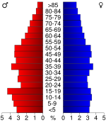
As of the census[8] of 2000, there were 9,955 people, 3,893 households, and 2,721 families residing in the county. The population density was 16 people per square mile (6/km²). There were 4,751 housing units at an average density of 8 per square mile (3/km²). The racial makeup of the county was 66.90% White, 31.18% Black or African American, 0.38% Native American, 0.06% Asian, 0.85% from other races, and 0.62% from two or more races. 1.52% of the population were Hispanic or Latino of any race.
There were 3,893 households out of which 31.40% had children under the age of 18 living with them, 51.90% were married couples living together, 14.00% had a female householder with no husband present, and 30.10% were non-families. 27.80% of all households were made up of individuals and 13.70% had someone living alone who was 65 years of age or older. The average household size was 2.48 and the average family size was 3.02.
In the county the population was spread out with 25.20% under the age of 18, 8.70% from 18 to 24, 26.10% from 25 to 44, 23.80% from 45 to 64, and 16.10% who were 65 years of age or older. The median age was 38 years. For every 100 females there were 94.40 males. For every 100 females age 18 and over, there were 89.90 males.
The median income for a household in the county was $26,962, and the median income for a family was $33,095. Males had a median income of $27,888 versus $17,920 for females. The per capita income for the county was $14,184. About 18.30% of families and 22.80% of the population were below the poverty line, including 28.00% of those under age 18 and 27.10% of those age 65 or over.
Cities and towns
Census designated place
Townships
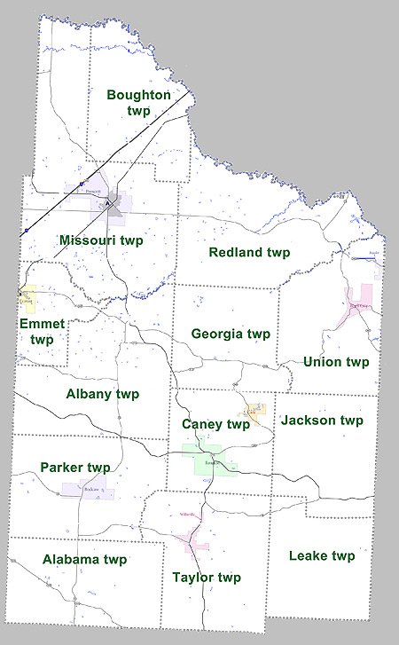
 Townships in Nevada County, Arkansas as of 2010
Townships in Arkansas are the divisions of a county. Each township includes unincorporated areas and some may have incorporated towns or cities within part of their space. Townships have limited purposes in modern times. However, the US Census does list Arkansas population based on townships (often referred to as "minor civil divisions"). Townships are also of value for historical purposes in terms of genealogical research. Each town or city is within one or more townships in an Arkansas county based on census maps. The townships of Nevada County are listed below with the town(s) and/or city that are fully or partially inside them listed in parentheses. [9][10]
- Alabama
- Albany
- Boughton
- Caney (Cale, Rosston)
- Emmet (Emmet)
- Georgia
- Jackson
- Leake
- Missouri (Prescott)
- Parker (Bodcaw)
- Redland
- Taylor (Willisville)
- Union (Bluff City, CDP Reader)
See also
References
- ^ "Find a County". National Association of Counties. http://www.naco.org/Counties/Pages/FindACounty.aspx. Retrieved 2011-06-07.
- ^ Marietta M. LeBreton, "Bayou Dorcheat" in The Rivers and Bayous of Louisiana by Edwin Adams Davis. ISBN 9781565544376. http://books.google.com/books?id=N6a-9ZHqz8oC&pg=PA45&lpg=PA45&dq=dorcheat+bayoiu#v=onepage&q=&f=false. Retrieved August 24, 2009.
- ^ "Census 2000 U.S. Gazetteer Files: Counties". United States Census. http://www.census.gov/tiger/tms/gazetteer/county2k.txt. Retrieved 2011-02-13.
- ^ http://www.census.gov/population/www/censusdata/cencounts/files/ar190090.txt
- ^ http://factfinder2.census.gov
- ^ http://mapserver.lib.virginia.edu/
- ^ Based on 2000 census data
- ^ "American FactFinder". United States Census Bureau. http://factfinder.census.gov. Retrieved 2008-01-31.
- ^ US Census Bureau. 2011 Boundary and Annexation Survey (BAS): Nevada County, AR (Map). http://www2.census.gov/geo/pvs/bas/bas11/st05_ar/cou/c05099_nevada/BAS11C20509900000_000.pdf. Retrieved 20110816.
- ^ http://www.census.gov/geo/www/maps/DC10_GUBlkMap/cousub/dc10blk_st05_cousub.html#N

Pike County Clark County Hempstead County 
Ouachita County  Nevada County, Arkansas

Lafayette County Columbia County Municipalities and communities of Nevada County, Arkansas Cities 
Towns Bluff City | Bodcaw | Cale | Rosston | Willisville
CDP Unincorporated
communityLaneburg
Footnotes ‡This populated place also has portions in an adjacent county or counties
 State of Arkansas
Topics - Index
- Arkansans
- Constitution
- Delegations
- Geography
- Government
- Governor (List)
- History
- Images
- Places
- Transportation
- Visitor Attractions
Society - Culture
- Crime
- Demographics
- Economy
- Education
- Politics
Regions Metros Largest cities Other cities Counties - Arkansas
- Ashley
- Baxter
- Benton
- Boone
- Bradley
- Calhoun
- Carroll
- Chicot
- Clark
- Clay
- Cleburne
- Cleveland
- Columbia
- Conway
- Craighead
- Crawford
- Crittenden
- Cross
- Dallas
- Desha
- Drew
- Faulkner
- Franklin
- Fulton
- Garland
- Grant
- Greene
- Hempstead
- Hot Spring
- Howard
- Independence
- Izard
- Jackson
- Jefferson
- Johnson
- Lafayette
- Lawrence
- Lee
- Lincoln
- Little River
- Logan
- Lonoke
- Madison
- Marion
- Miller
- Mississippi
- Monroe
- Montgomery
- Nevada
- Newton
- Ouachita
- Perry
- Phillips
- Pike
- Poinsett
- Polk
- Pope
- Prairie
- Pulaski
- Randolph
- Saline
- Scott
- Searcy
- Sebastian
- Sevier
- Sharp
- St. Francis
- Stone
- Union
- Van Buren
- Washington
- White
- Woodruff
- Yell
Coordinates: 33°39′40″N 93°18′03″W / 33.66111°N 93.30083°W
Categories:- Arkansas counties
- Nevada County, Arkansas
- Hope micropolitan area
- 1871 establishments


Wikimedia Foundation. 2010.