- Grant County, Arkansas
-
Grant County, Arkansas 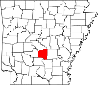
Location in the state of Arkansas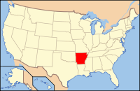
Arkansas's location in the U.S.Founded February 4, 1870 Seat Sheridan Area
- Total
- Land
- Water
633.01 sq mi (1,639 km²)
631.78 sq mi (1,636 km²)
1.23 sq mi (3 km²), 0.19%Population
- (2010)
- Density
17,853
28/sq mi (10.91/km²)Grant County is a county in the U.S. state of Arkansas. Its population was 17,853 at the 2010 United States Census. The county seat is Sheridan.[1] Grant County is included in the Little Rock–North Little Rock–Conway Metropolitan Statistical Area.It is a rural county.The county seat, Sheridan was named after Union General Philip Sheridan.
Grant County was formed on February 4, 1869, and named for Ulysses S. Grant, president of the United States. It is an alcohol prohibition or dry county.
Robert W. Glover, a Missionary Baptist pastor who served in both houses of the Arkansas Legislature (1905-1912) from Sheridan, introduced in 1909 the resolution calling for the establishment of four state agricultural colleges.[2]
Contents
Geography
According to the 2000 census, the county has a total area of 633.01 square miles (1,639.5 km2), of which 631.78 square miles (1,636.3 km2) (or 99.81%) is land and 1.23 square miles (3.2 km2) (or 0.19%) is water.[3]
Major highways
 U.S. Highway 167
 U.S. Highway 270
 Highway 35
 Highway 46
Adjacent counties
- Saline County (north)
- Pulaski County (northeast)
- Jefferson County (east)
- Cleveland County (southeast)
- Dallas County (south)
- Hot Spring County (west)
Demographics
Historical populations Census Pop. %± 1870 3,943 — 1880 6,185 56.9% 1890 7,786 25.9% 1900 7,671 −1.5% 1910 9,425 22.9% 1920 10,710 13.6% 1930 9,834 −8.2% 1940 10,477 6.5% 1950 9,024 −13.9% 1960 8,294 −8.1% 1970 9,711 17.1% 1980 13,008 34.0% 1990 13,948 7.2% 2000 16,464 18.0% 2010 17,853 8.4% [4][5][6] 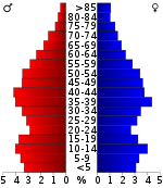
As of the census[8] of 2000, there were 16,464 people, 4,241 households, and 4,780 families residing in the county. The population density was 26 people per square mile (10/km²). There were 6,960 housing units at an average density of 11 per square mile (4/km²). The racial makeup of the county was 95.55% White, 2.47% Black or African American, 0.45% Native American, 0.13% Asian, 0.03% Pacific Islander, 0.64% from other races, and 0.73% from two or more races. 1.15% of the population were Hispanic or Latino of any race.
There were 6,241 households out of which 35.60% had children under the age of 18 living with them, 64.70% were married couples living together, 8.50% had a female householder with no husband present, and 23.40% were non-families. 20.40% of all households were made up of individuals and 9.00% had someone living alone who was 65 years of age or older. The average household size was 2.61 and the average family size was 3.00.
In the county the population was spread out with 25.90% under the age of 18, 8.00% from 18 to 24, 29.60% from 25 to 44, 24.30% from 45 to 64, and 12.20% who were 65 years of age or older. The median age was 37 years. For every 100 females there were 98.50 males. For every 100 females age 18 and over, there were 96.30 males.
The median income for a household in the county was $37,182, and the median income for a family was $42,901. Males had a median income of $31,842 versus $22,098 for females. The per capita income for the county was $17,547. About 7.80% of families and 10.20% of the population were below the poverty line, including 12.50% of those under age 18 and 13.00% of those age 65 or over.
Cities and towns
Townships
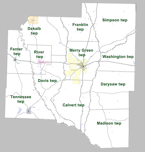
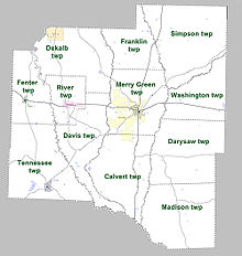 Townships in Grant County, Arkansas as of 2010
Townships in Arkansas are the divisions of a county. Each township includes unincorporated areas and some may have incorporated towns or cities within part of their space. Townships have limited purposes in modern times. However, the US Census does list Arkansas population based on townships (often referred to as "minor civil divisions"). Townships are also of value for historical purposes in terms of genealogical research. Each town or city is within one or more townships in an Arkansas county based on census maps. The townships of Grant County are listed below with the town(s) and/or city that are fully or partially inside them listed in parentheses. [9][10]
- Calvert (small part of Sheridan)
- Darysaw
- Davis
- Dekalb (Tull)
- Fenter (Poyen)
- Franklin
- Madison
- Merry Green (most of Sheridan)
- River (Prattsville)
- Simpson
- Tennessee (Leola)
- Washington
See also
References
- ^ "Find a County". National Association of Counties. http://www.naco.org/Counties/Pages/FindACounty.aspx. Retrieved 2011-06-07.
- ^ "ASU-Jonesboro: Act 100 Re-enactment Ceremony". astate.edu. http://www.astate.edu/a/centennial/centennial-events-gallery/act-100-re-enactment-ceremony/. Retrieved July 5, 2011.
- ^ "Census 2000 U.S. Gazetteer Files: Counties". United States Census. http://www.census.gov/tiger/tms/gazetteer/county2k.txt. Retrieved 2011-02-13.
- ^ http://www.census.gov/population/www/censusdata/cencounts/files/ar190090.txt
- ^ http://factfinder2.census.gov
- ^ http://mapserver.lib.virginia.edu/
- ^ Based on 2000 census data
- ^ "American FactFinder". United States Census Bureau. http://factfinder.census.gov. Retrieved 2008-01-31.
- ^ US Census Bureau. 2011 Boundary and Annexation Survey (BAS): Grant County, AR (Map). http://www2.census.gov/geo/pvs/bas/bas11/st05_ar/cou/c05053_grant/BAS11C20505300000_000.pdf. Retrieved 20110814.
- ^ http://www.census.gov/geo/www/maps/DC10_GUBlkMap/cousub/dc10blk_st05_cousub.html#G

Saline County Pulaski County Hot Spring County 
Jefferson County  Grant County, Arkansas

Dallas County Cleveland County Municipalities and communities of Grant County, Arkansas City 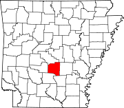
Towns Leola | Poyen | Prattsville | Tull
Unincorporated
communityGrapevine
 State of Arkansas
Topics - Index
- Arkansans
- Constitution
- Delegations
- Geography
- Government
- Governor (List)
- History
- Images
- Places
- Transportation
- Visitor Attractions
Society - Culture
- Crime
- Demographics
- Economy
- Education
- Politics
Regions Metros Largest cities Other cities Counties - Arkansas
- Ashley
- Baxter
- Benton
- Boone
- Bradley
- Calhoun
- Carroll
- Chicot
- Clark
- Clay
- Cleburne
- Cleveland
- Columbia
- Conway
- Craighead
- Crawford
- Crittenden
- Cross
- Dallas
- Desha
- Drew
- Faulkner
- Franklin
- Fulton
- Garland
- Grant
- Greene
- Hempstead
- Hot Spring
- Howard
- Independence
- Izard
- Jackson
- Jefferson
- Johnson
- Lafayette
- Lawrence
- Lee
- Lincoln
- Little River
- Logan
- Lonoke
- Madison
- Marion
- Miller
- Mississippi
- Monroe
- Montgomery
- Nevada
- Newton
- Ouachita
- Perry
- Phillips
- Pike
- Poinsett
- Polk
- Pope
- Prairie
- Pulaski
- Randolph
- Saline
- Scott
- Searcy
- Sebastian
- Sevier
- Sharp
- St. Francis
- Stone
- Union
- Van Buren
- Washington
- White
- Woodruff
- Yell
Coordinates: 34°17′40″N 92°25′54″W / 34.29444°N 92.43167°W
Categories:- Arkansas counties
- Grant County, Arkansas
- 1870 establishments
- Little Rock – North Little Rock metropolitan area


Wikimedia Foundation. 2010.