- Crawford County, Arkansas
-
Crawford County, Arkansas 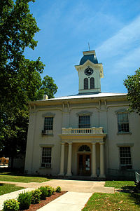 Crawford County Courthouse within the Van Buren Historic District in Van Buren, Arkansas
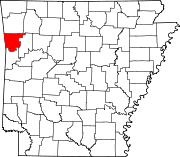
Location in the state of Arkansas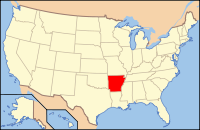
Arkansas's location in the U.S.Founded 1820 Seat Van Buren Area
- Total
- Land
- Water
604.20 sq mi (1,565 km²)
595.39 sq mi (1,542 km²)
8.81 sq mi (23 km²),Population
- (2010)
- Density
61,948
104/sq mi (40.17/km²)Crawford County is a county located in the U.S. state of Arkansas. It is part of the Fort Smith, Arkansas-Oklahoma Metropolitan Statistical Area. As of the 2010 census, the population was 61,948. The county seat is Van Buren.[1] Crawford County was formed on October 18, 1820, and named for William H. Crawford who was United States Secretary of War in 1815. As a dry county, alcohol sales are generally prohibited, though recent changes to county law provide for exemptions.
Contents
Geography
According to the 2000 census, the county has a total area of 604.20 square miles (1,564.9 km2), of which 595.39 square miles (1,542.1 km2) (or 98.54%) is land and 8.81 square miles (22.8 km2) (or 1.46%) is water.[2]
Major highways
 Interstate 40
 Interstate 540
 U.S. Highway 64
 U.S. Highway 71
 Highway 59
 Highway 60
Crawford County is included in an area designated for a planned extension of Interstate 49 into Arkansas. The final project will connect New Orleans, Louisiana to Kansas City, Missouri, a large trucking corridor which is currently not served by an Interstate highway. The proposed highway would utilize portions of Interstate 540 which currently runs north from Van Buren toward the Missouri state line passing through Benton County, home of Wal-Mart. The corridor was listed as the number-one high-priority corridor by transportation officials in the Intermodal Surface Transportation Efficiency Act.
Adjacent counties
- Washington County (north)
- Madison County (northeast)
- Franklin County (east)
- Sebastian County (south)
- Le Flore County, Oklahoma (southwest)
- Sequoyah County, Oklahoma (west)
- Adair County, Oklahoma (northwest)
National protected area
- Ozark National Forest (part)
Demographics
Historical populations Census Pop. %± 1830 2,440 — 1840 4,266 74.8% 1850 7,960 86.6% 1860 7,850 −1.4% 1870 8,957 14.1% 1880 14,740 64.6% 1890 21,714 47.3% 1900 21,270 −2.0% 1910 23,942 12.6% 1920 25,739 7.5% 1930 22,549 −12.4% 1940 23,920 6.1% 1950 22,727 −5.0% 1960 21,318 −6.2% 1970 25,677 20.4% 1980 36,892 43.7% 1990 42,493 15.2% 2000 53,247 25.3% 2010 61,948 16.3% [3][4][5] As of the census[6] of 2000, there were 53,247 people, 19,702 households, and 15,150 families residing in the county. The population density was 35/km² (89/mi²). There were 21,315 housing units at an average density of 14/km² (36/mi²). The racial makeup of the county was 92.19% White, 0.87% Black or African American, 2.01% Native American, 1.19% Asian, 0.02% Pacific Islander, 1.48% from other races, and 2.24% from two or more races. 3.27% of the population were Hispanic or Latino of any race.
There were 19,702 households out of which 37.50% had children under the age of 18 living with them, 62.20% were married couples living together, 10.90% had a female householder with no husband present, and 23.10% were non-families. 20.00% of all households were made up of individuals and 8.20% had someone living alone who was 65 years of age or older. The average household size was 2.68 and the average family size was 3.07.
In the county the population was spread out with 28.20% under the age of 18, 8.40% from 18 to 24, 29.30% from 25 to 44, 22.80% from 45 to 64, and 11.30% who were 65 years of age or older. The median age was 35 years. For every 100 females there were 97.70 males. For every 100 females age 18 and over, there were 94.20 males.
The median income for a household in the county was $32,871, and the median income for a family was $36,741. Males had a median income of $29,581 versus $20,352 for females. The per capita income for the county was $15,015. About 10.90% of families and 14.20% of the population were below the poverty line, including 19.30% of those under age 18 and 13.70% of those age 65 or over.
Controversy
Thousands of self-claimed "Western Band of Cherokee" (or Arkansas Cherokees) fought for state and federal recognition as a political entity of Native Americans. Crawford County was historically part of the Cherokee Nation, which lost its tribal sovereignty status as a result of the U.S. Civil war in the 1860s. The Cherokee Nation was subsequently relocated to the west in the present-day state of Oklahoma.[citation needed]
Cities and towns
Unincorporated communities
Townships
Townships in Arkansas are the divisions of a county. Each township includes unincorporated areas and some may have incorporated towns or cities within part of their space. Townships have limited purposes in modern times. However, the US Census does list Arkansas population based on townships (often referred to as "minor civil divisions"). Townships are also of value for historical purposes in terms of genealogical research. Each town or city is within one or more townships in an Arkansas county based on census maps. The townships of Crawford County are listed below with the town(s) and/or city that are fully or partially inside them listed in parentheses. [7][8]
- Alma (most of Alma)
- Bidville
- Cedar Creek
- Cedarville (Cedarville)
- Chester (Chester, small part of Mountainburg)
- Cove City
- Dean Springs (small part of Alma)
- Dora (part of Van Buren)
- Dyer (Dyer, small part of Alma)
- Jasper
- Kibler (most of Kibler)
- Lancaster
- Lees Creek
- Locke
- Mountainburg (most of Mountainburg)
- Mulberry (most of Mulberry)
- Oliver Springs
- Porter
- Rudy (Rudy, very small part of Alma)
- Uniontown
- Upper
- Van Buren (most of Van Buren, part of Kibler)
- Vine Prairie (part of Mulberry)
- Whitley
- Winfrey
See also
References
- ^ "Find a County". National Association of Counties. http://www.naco.org/Counties/Pages/FindACounty.aspx. Retrieved 2011-06-07.
- ^ "Census 2000 U.S. Gazetteer Files: Counties". United States Census. http://www.census.gov/tiger/tms/gazetteer/county2k.txt. Retrieved 2011-02-13.
- ^ http://www.census.gov/population/www/censusdata/cencounts/files/ar190090.txt
- ^ http://factfinder2.census.gov
- ^ http://mapserver.lib.virginia.edu/
- ^ "American FactFinder". United States Census Bureau. http://factfinder.census.gov. Retrieved 2008-01-31.
- ^ US Census Bureau. 2011 Boundary and Annexation Survey (BAS): Crawford County, AR (Map). http://www2.census.gov/geo/pvs/bas/bas11/st05_ar/cou/c05033_crawford/BAS11C20503300000_000.pdf. Retrieved 20110825.
- ^ http://www.census.gov/geo/www/maps/DC10_GUBlkMap/cousub/dc10blk_st05_cousub.html#C
External links

Adair County, Oklahoma Washington County Madison County Sequoyah County, Oklahoma 
Franklin County  Crawford County, Arkansas

Le Flore County, Oklahoma Sebastian County Municipalities and communities of Crawford County, Arkansas Cities Alma | Cedarville | Kibler | Mountainburg | Mulberry | Van Buren
Towns Unincorporated
communitiesArtist Point | Dora | Natural Dam | Uniontown
 State of Arkansas
Topics - Index
- Arkansans
- Constitution
- Delegations
- Geography
- Government
- Governor (List)
- History
- Images
- Places
- Transportation
- Visitor Attractions
Society - Culture
- Crime
- Demographics
- Economy
- Education
- Politics
Regions Metros Largest cities Other cities Counties - Arkansas
- Ashley
- Baxter
- Benton
- Boone
- Bradley
- Calhoun
- Carroll
- Chicot
- Clark
- Clay
- Cleburne
- Cleveland
- Columbia
- Conway
- Craighead
- Crawford
- Crittenden
- Cross
- Dallas
- Desha
- Drew
- Faulkner
- Franklin
- Fulton
- Garland
- Grant
- Greene
- Hempstead
- Hot Spring
- Howard
- Independence
- Izard
- Jackson
- Jefferson
- Johnson
- Lafayette
- Lawrence
- Lee
- Lincoln
- Little River
- Logan
- Lonoke
- Madison
- Marion
- Miller
- Mississippi
- Monroe
- Montgomery
- Nevada
- Newton
- Ouachita
- Perry
- Phillips
- Pike
- Poinsett
- Polk
- Pope
- Prairie
- Pulaski
- Randolph
- Saline
- Scott
- Searcy
- Sebastian
- Sevier
- Sharp
- St. Francis
- Stone
- Union
- Van Buren
- Washington
- White
- Woodruff
- Yell
Coordinates: 35°34′07″N 94°15′10″W / 35.56861°N 94.25278°W
Categories:- Arkansas counties
- 1820 establishments in the United States
- Populated places established in 1820
- Crawford County, Arkansas
- Fort Smith metropolitan area


Wikimedia Foundation. 2010.