- Conway County, Arkansas
-
Conway County, Arkansas 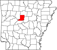
Location in the state of Arkansas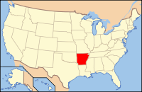
Arkansas's location in the U.S.Founded October 20, 1825 Seat Morrilton Area
- Total
- Land
- Water
566.66 sq mi (1,468 km²)
556.15 sq mi (1,440 km²)
10.51 sq mi (27 km²), 1.85%Population
- (2010)
- Density
21,273
38/sq mi (14.7/km²)Conway County is a county located in the U.S. state of Arkansas. As of 2010, the population was 21,273. The county seat is Morrilton.[1] Conway County was formed on October 20, 1825, from a portion of Pulaski County and named for Henry Wharton Conway who was the territorial delegate to the U.S. Congress.
Contents
Geography
According to the 2000 census, the county has a total area of 566.66 square miles (1,467.6 km2), of which 556.15 square miles (1,440.4 km2) (or 98.15%) is land and 10.51 square miles (27.2 km2) (or 1.85%) is water.[2]
Major highways
 Interstate 40
 U.S. Highway 64
 Highway 9
 Highway 92
 Highway 95
 Highway 124
 Highway 154
Adjacent counties
- Van Buren County (north)
- Faulkner County (east)
- Perry County (south)
- Yell County (southwest)
- Pope County (west)
National protected area
- Ozark National Forest (part)
Demographics
Historical populations Census Pop. %± 1830 982 — 1840 2,892 194.5% 1850 3,583 23.9% 1860 6,697 86.9% 1870 8,112 21.1% 1880 12,755 57.2% 1890 19,459 52.6% 1900 19,772 1.6% 1910 22,729 15.0% 1920 22,578 −0.7% 1930 21,949 −2.8% 1940 21,536 −1.9% 1950 18,137 −15.8% 1960 15,430 −14.9% 1970 16,805 8.9% 1980 19,505 16.1% 1990 19,151 −1.8% 2000 20,336 6.2% 2010 21,273 4.6% [3][4][5]  Age pyramid Conway County[6]
As of the census[7] of 2000, there were 20,336 people, 7,967 households, and 5,736 families residing in the county. The population density was 37 people per square mile (14/km²). There were 9,028 housing units at an average density of 16 per square mile (6/km²). The racial makeup of the county was 84.27% White, 13.05% Black or African American, 0.50% Native American, 0.23% Asian, 0.03% Pacific Islander, 0.74% from other races, and 1.18% from two or more races. 1.77% of the population were Hispanic or Latino of any race.
There were 7,967 households out of which 31.40% had children under the age of 18 living with them, 56.70% were married couples living together, 11.50% had a female householder with no husband present, and 28.00% were non-families. 25.40% of all households were made up of individuals and 12.10% had someone living alone who was 65 years of age or older. The average household size was 2.51 and the average family size was 2.99.
In the county the population was spread out with 25.40% under the age of 18, 8.30% from 18 to 24, 26.70% from 25 to 44, 23.50% from 45 to 64, and 16.10% who were 65 years of age or older. The median age was 38 years. For every 100 females there were 94.40 males. For every 100 females age 18 and over, there were 91.50 males.
The median income for a household in the county was $31,209, and the median income for a family was $38,179. Males had a median income of $28,199 versus $20,134 for females. The per capita income for the county was $16,056. About 12.20% of families and 16.10% of the population were below the poverty line, including 21.90% of those under age 18 and 13.10% of those age 65 or over.
History
 Henry W. Conway, namesake for Conway County.
Conway County was formed on October 20, 1825 from a portion of Pulaski County and named for Henry Wharton Conway who was the territorial delegate to the U.S. Congress.
Cities and towns
- Blackwell
- Formosa
- Menifee
- Morrilton
- Oppelo
- Plumerville
Unincorporatd communities
- Lanty
- Solgohachia
- Springfield
Census designated place
Townships
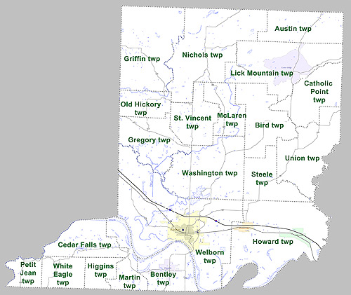
 Townships in Conway County, Arkansas as of 2010
Townships in Arkansas are the divisions of a county. Each township includes unincorporated areas and some may have incorporated towns or cities within part of their space. Townships have limited purposes in modern times. However, the US Census does list Arkansas population based on townships (often referred to as "minor civil divisions"). Townships are also of value for historical purposes in terms of genealogical research. Each town or city is within one or more townships in an Arkansas county based on census maps. The townships of Conway County are listed below with the town(s) and/or city that are fully or partially inside them listed in parentheses. [8][9]
- Austin
- Bentley (Oppelo)
- Bird
- Catholic Point
- Cedar Falls
- Gregory
- Griffin
- Higgins
- Howard (Menifee, Plumerville)
- Lick Mountain (CDP Center Ridge)
- McLaren
- Martin
- Nichols
- Old Hickory
- Petit Jean
- St. Vincent
- Steele
- Union
- Washington
- Welborn (Morrilton)
- White Eagle
See also
References
- ^ "Find a County". National Association of Counties. http://www.naco.org/Counties/Pages/FindACounty.aspx. Retrieved 2011-06-07.
- ^ "Census 2000 U.S. Gazetteer Files: Counties". United States Census. http://www.census.gov/tiger/tms/gazetteer/county2k.txt. Retrieved 2011-02-13.
- ^ http://www.census.gov/population/www/censusdata/cencounts/files/ar190090.txt
- ^ http://factfinder2.census.gov
- ^ http://mapserver.lib.virginia.edu/
- ^ Based on 2000 census data
- ^ "American FactFinder". United States Census Bureau. http://factfinder.census.gov. Retrieved 2008-01-31.
- ^ US Census Bureau. 2011 Boundary and Annexation Survey (BAS): Conway County, AR (Map). http://www2.census.gov/geo/pvs/bas/bas11/st05_ar/cou/c05029_conway/BAS11C20502900000_000.pdf. Retrieved 20110819.
- ^ http://www.census.gov/geo/www/maps/DC10_GUBlkMap/cousub/dc10blk_st05_cousub.html#C
External links
- 10th Arkansas Infantry, Local Regiment During the Civil War

Van Buren County Pope County 
Faulkner County  Conway County, Arkansas

Yell County Perry County Municipalities and communities of Conway County, Arkansas Cities 
Town CDP Unincorporated
communitiesCleveland | Hattieville | Jerusalem | Solgohachia | Springfield | Winrock
 State of Arkansas
Topics - Index
- Arkansans
- Constitution
- Delegations
- Geography
- Government
- Governor (List)
- History
- Images
- Places
- Transportation
- Visitor Attractions
Society - Culture
- Crime
- Demographics
- Economy
- Education
- Politics
Regions Metros Largest cities Other cities Counties - Arkansas
- Ashley
- Baxter
- Benton
- Boone
- Bradley
- Calhoun
- Carroll
- Chicot
- Clark
- Clay
- Cleburne
- Cleveland
- Columbia
- Conway
- Craighead
- Crawford
- Crittenden
- Cross
- Dallas
- Desha
- Drew
- Faulkner
- Franklin
- Fulton
- Garland
- Grant
- Greene
- Hempstead
- Hot Spring
- Howard
- Independence
- Izard
- Jackson
- Jefferson
- Johnson
- Lafayette
- Lawrence
- Lee
- Lincoln
- Little River
- Logan
- Lonoke
- Madison
- Marion
- Miller
- Mississippi
- Monroe
- Montgomery
- Nevada
- Newton
- Ouachita
- Perry
- Phillips
- Pike
- Poinsett
- Polk
- Pope
- Prairie
- Pulaski
- Randolph
- Saline
- Scott
- Searcy
- Sebastian
- Sevier
- Sharp
- St. Francis
- Stone
- Union
- Van Buren
- Washington
- White
- Woodruff
- Yell
Coordinates: 35°15′52″N 92°41′56″W / 35.26444°N 92.69889°W
Categories:- Arkansas counties
- Conway County, Arkansas
- 1825 establishments in the United States
- Populated places established in 1825


Wikimedia Foundation. 2010.