- National Register of Historic Places listings in Clay County, Arkansas
-
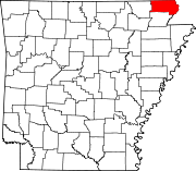
 Location of Clay County in Arkansas
This is a list of the National Register of Historic Places listings in Clay County, Arkansas.
This is intended to be a complete list of the properties and districts on the National Register of Historic Places in Clay County, Arkansas, United States. The locations of National Register properties and districts for which the latitude and longitude coordinates are included below, may be seen in a Google map.[1]
There are 17 properties and districts listed on the National Register in the county.
Contents: Counties in Arkansas Arkansas - Ashley - Baxter - Benton - Boone - Bradley - Calhoun - Carroll - Chicot - Clark - Clay - Cleburne - Cleveland - Columbia - Conway - Craighead - Crawford - Crittenden - Cross - Dallas - Desha - Drew - Faulkner - Franklin - Fulton - Garland - Grant - Greene - Hempstead - Hot Spring - Howard - Independence - Izard - Jackson - Jefferson - Johnson - Lafayette - Lawrence - Lee - Lincoln - Little River - Logan - Lonoke - Madison - Marion - Miller - Mississippi - Monroe - Montgomery - Nevada - Newton - Ouachita - Perry - Phillips - Pike - Poinsett - Polk - Pope - Prairie - Pulaski (Little Rock) - Randolph - St. Francis - Saline - Scott - Searcy - Sebastian - Sevier - Sharp - Stone - Union - Van Buren - Washington - White - Woodruff - Yell
-
- This National Park Service list is complete through NPS recent listings posted November 10, 2011.[2]
Current listings
[3] Landmark name [4] Image Date listed Location City or town Summary 1 Baynham House August 31, 1978 Stephens St.
36°27′05″N 90°43′29″W / 36.451389°N 90.724722°WSuccess 2 Chalk Bluff October 29, 1974 North of St. Francis
36°28′41″N 90°09′32″W / 36.478056°N 90.158889°WSt. Francis 3 County Home Cemetery March 22, 2005 3010 Heritage Park Rd.
36°23′11″N 90°12′39″W / 36.386389°N 90.210833°WPiggott 4 Eastern Star Lodge 207 F&AM October 4, 2002 Approximately 1.5 miles west on County Road 336, then 0.5 miles south Cty Rte. 347
36°27′05″N 90°10′31″W / 36.451389°N 90.175278°WSt. Francis 5 Esso Station June 2, 2000 287 W. Main
36°22′34″N 90°11′16″W / 36.376111°N 90.187778°WPiggott 6 Knob School-Masonic Lodge May 30, 1991 Highway 141
36°16′53″N 90°27′00″W / 36.281389°N 90.45°WKnob 7 Oliver House December 8, 1978 203 W. Front St.
36°24′35″N 90°34′44″W / 36.409722°N 90.578889°WCorning 8 Pfeiffer House and Carriage House 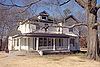
June 10, 1982 10th and Cherry Sts.
36°23′04″N 90°12′00″W / 36.384444°N 90.2°WPiggott 9 Piggott Commercial Historic District November 4, 2009 Roughly bounded on the north by W. Cherry, on the south by W. Court, on the east by S. Throckmorton, and on the west by Clay
36°22′58″N 90°11′26″W / 36.382839°N 90.190656°WPiggott 10 Piggott National Guard Armory May 31, 2006 775 E. Main St.
36°22′59″N 90°10′53″W / 36.383056°N 90.181389°WPiggott 11 Piggott Post Office August 14, 1998 119 N. 3rd St.
36°23′00″N 90°11′33″W / 36.383333°N 90.1925°WPiggott 12 Rector Commercial Historic District June 1, 2009 Bounded by the former St. Louis Southwestern Railway railroad tracks on the east and south, S. Dodd on the west, and 3rd St. on the north
36°15′49″N 90°17′34″W / 36.263686°N 90.292717°WRector 13 Rector Waterworks Building May 12, 2009 703 S. Main St.
36°15′39″N 90°17′34″W / 36.26075°N 90.292722°WRector 14 Scatterville Cemetery March 31, 1995 County Road 404, 1.5 miles west of Highway 90
36°16′55″N 90°18′47″W / 36.281944°N 90.313056°WRector 15 Sheeks House August 22, 1975 502 Market St.
36°24′18″N 90°35′02″W / 36.405°N 90.583889°WCorning 16 Sink-Crumb Post No. 72 American Legion Hut September 25, 2008 Northeastern corner of the junction of 2nd and Cherry Sts.
36°19′13″N 90°36′01″W / 36.320308°N 90.600222°WKnobel 17 Waddle House March 28, 1977 S. Erwin
36°27′04″N 90°43′21″W / 36.451111°N 90.7225°WSuccess See also
- List of National Historic Landmarks in Arkansas
- National Register of Historic Places listings in Arkansas
References
- ^ The latitude and longitude information provided in this table was derived originally from the National Register Information System, which has been found to be fairly accurate for about 99% of listings. For about 1% of NRIS original coordinates, experience has shown that one or both coordinates are typos or otherwise extremely far off; some corrections may have been made. A more subtle problem causes many locations to be off by up to 150 yards, depending on location in the country: most NRIS coordinates were derived from tracing out latitude and longitudes off of USGS topographical quadrant maps created under the North American Datum of 1927, which differs from the current, highly accurate WGS84 GPS system used by Google maps. Chicago is about right, but NRIS longitudes in Washington are higher by about 4.5 seconds, and are lower by about 2.0 seconds in Maine. Latitudes differ by about 1.0 second in Florida. Some locations in this table may have been corrected to current GPS standards.
- ^ "National Register of Historic Places: Weekly List Actions". National Park Service, United States Department of the Interior. Retrieved on November 10, 2011.
- ^ Numbers represent an ordering by significant words. Various colorings, defined here, differentiate National Historic Landmark sites and National Register of Historic Places Districts from other NRHP buildings, structures, sites or objects.
- ^ "National Register Information System". National Register of Historic Places. National Park Service. . http://nrhp.focus.nps.gov/natreg/docs/All_Data.html.
U.S. National Register of Historic Places Topics Lists by states Alabama • Alaska • Arizona • Arkansas • California • Colorado • Connecticut • Delaware • Florida • Georgia • Hawaii • Idaho • Illinois • Indiana • Iowa • Kansas • Kentucky • Louisiana • Maine • Maryland • Massachusetts • Michigan • Minnesota • Mississippi • Missouri • Montana • Nebraska • Nevada • New Hampshire • New Jersey • New Mexico • New York • North Carolina • North Dakota • Ohio • Oklahoma • Oregon • Pennsylvania • Rhode Island • South Carolina • South Dakota • Tennessee • Texas • Utah • Vermont • Virginia • Washington • West Virginia • Wisconsin • WyomingLists by territories Lists by associated states Other Municipalities and communities of Clay County, Arkansas Cities Corning | Piggott | Rector | St. Francis
Towns Unincorporated
communityCategories:- Clay County, Arkansas
- National Register of Historic Places in Arkansas by county
-


Wikimedia Foundation. 2010.