- National Register of Historic Places listings in Garland County, Arkansas
-
 Location of Garland County in Arkansas
This is a list of the National Register of Historic Places listings in Garland County, Arkansas.
This is intended to be a complete list of the properties and districts on the National Register of Historic Places in Garland County, Arkansas, United States. The locations of National Register properties and districts for which the latitude and longitude coordinates are included below, may be seen in a Google map.[1]
There are 80 properties and districts listed on the National Register in the county, including 1 National Historic Landmark.
Contents: Counties in Arkansas Arkansas - Ashley - Baxter - Benton - Boone - Bradley - Calhoun - Carroll - Chicot - Clark - Clay - Cleburne - Cleveland - Columbia - Conway - Craighead - Crawford - Crittenden - Cross - Dallas - Desha - Drew - Faulkner - Franklin - Fulton - Garland - Grant - Greene - Hempstead - Hot Spring - Howard - Independence - Izard - Jackson - Jefferson - Johnson - Lafayette - Lawrence - Lee - Lincoln - Little River - Logan - Lonoke - Madison - Marion - Miller - Mississippi - Monroe - Montgomery - Nevada - Newton - Ouachita - Perry - Phillips - Pike - Poinsett - Polk - Pope - Prairie - Pulaski (Little Rock) - Randolph - St. Francis - Saline - Scott - Searcy - Sebastian - Sevier - Sharp - Stone - Union - Van Buren - Washington - White - Woodruff - Yell
-
- This National Park Service list is complete through NPS recent listings posted November 10, 2011.[2]
Current listings
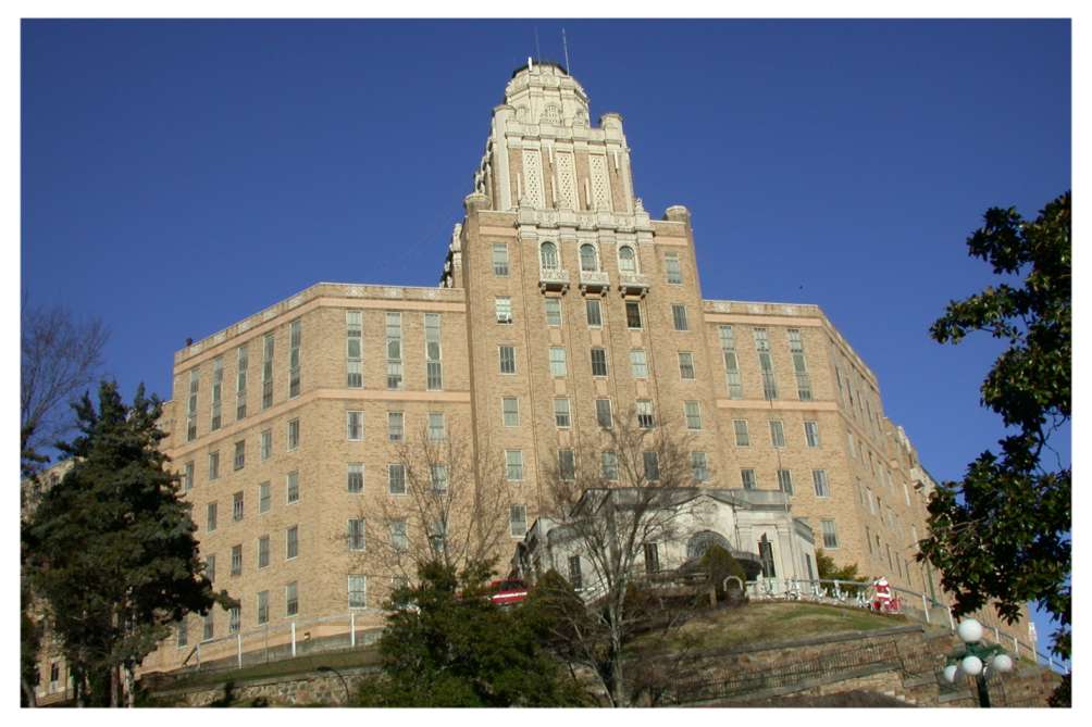
[3] Landmark name [4] Image Date listed Location City or town Summary 1 Army and Navy General Hospital Historic District 
February 9, 2007 105, 200, 417, 421 and 425 Reserve St.
34°30′43″N 93°03′01″W / 34.512022°N 93.050383°WHot Springs 2 Bathhouse Row 
November 13, 1974 Central Ave. between Reserve and Fountain Sts. in Hot Springs National Park
34°30′50″N 93°03′13″W / 34.513889°N 93.053611°WHot Springs 3 Walter Beauchamp House May 19, 1994 492 Prospect Ave.
34°30′27″N 93°03′37″W / 34.5075°N 93.060278°WHot Springs 4 Belding-Gaines Cemetery February 25, 1993 U.S. Route 270
34°28′06″N 92°58′45″W / 34.468333°N 92.979167°WHot Springs 5 Bellaire Court Historic District February 11, 2004 637 Park Ave.
34°31′28″N 93°03′11″W / 34.524444°N 93.053056°WHot Springs 6 W.C. Brown House October 16, 1986 2330 Central Ave.
34°29′21″N 93°03′33″W / 34.489167°N 93.059167°WHot Springs 7 Buckville Cemetery September 27, 2007 Buckville Rd.
34°36′51″N 93°20′32″W / 34.614167°N 93.342222°WAvant 8 Butchie's Drive-In February 11, 2004 534 Park Ave.
34°31′23″N 93°03′13″W / 34.523056°N 93.053611°WHot Springs 9 Camp Clearfork Historic District October 21, 1993 South of U.S. Route 270 and west of Crystal Springs in the Ouachita National Forest
34°30′28″N 93°23′36″W / 34.507778°N 93.393333°WCrystal Springs 10 Carpenter Dam September 4, 1992 1398 Carpenter Dam Rd.
34°26′32″N 93°01′33″W / 34.442222°N 93.025833°WHot Springs 11 CCC Company 3767 Powder Magazine Historic District March 30, 2007 K59P Rd., north of Forest Service Rd. 11 (Gladstone Rd.) Jessieville 12 Central Methodist Episcopal Church South September 23, 2011 1100 Central Ave.
34°30′17″N 93°03′20″W / 34.504722°N 93.055556°WHot Springs 13 Charlton Bathhouse October 20, 1993 North of U.S. Route 270 and west of Crystal Springs in the Ouachita National Forest
34°29′23″N 93°22′16″W / 34.489722°N 93.371111°WCrystal Springs 14 Charlton Spillway-Dam October 21, 1993 North of U.S. Route 270 and west of Crystal Springs in the Ouachita National Forest
34°31′03″N 93°22′53″W / 34.5175°N 93.381389°WCrystal Springs 15 Citizens Building August 9, 1979 723 Central Ave.
34°30′43″N 93°03′51″W / 34.511944°N 93.064167°WHot Springs 16 Bill Clinton Boyhood Home May 18, 1995 1011 Park Ave.
34°31′53″N 93°02′45″W / 34.531389°N 93.045833°WHot Springs 17 Cottage Courts Historic District February 11, 2004 603 Park Ave.
34°31′26″N 93°03′12″W / 34.523889°N 93.053333°WHot Springs 18 Couchwood December 4, 1986 On the grounds of the Couchwood estate
34°26′57.5″N 92°54′53.4″W / 34.449306°N 92.914833°W[5]Shorewood Hills Extends into Hot Spring County 19 Cove Tourist Court February 11, 2004 771 Park Ave.
34°31′38″N 93°03′05″W / 34.527222°N 93.051389°WHot Springs 20 Doherty House November 14, 1978 705 Malvern Ave.
34°30′16″N 93°02′53″W / 34.504444°N 93.048056°WHot Springs 21 First Presbyterian Church December 22, 1982 213 Whittington
34°30′58″N 93°03′33″W / 34.516111°N 93.059167°WHot Springs 22 Fordyce House December 22, 1982 746 Park Ave.
34°31′45″N 93°02′58″W / 34.529167°N 93.049444°WHot Springs 23 Fordyce-Ricks House Historic District October 31, 2003 1501 Park Ave.
34°32′11″N 93°02′01″W / 34.536389°N 93.033611°WHot Springs 24 Forest Service Headquarters Historic District October 20, 1993 South of the junction of Winona and Indiana Sts.
34°29′32″N 93°03′16″W / 34.492222°N 93.054444°WHot Springs 25 Garland County Courthouse December 6, 1979 Ouachita and Hawthorne Aves
34°30′17″N 93°03′32″W / 34.504722°N 93.058889°WHot Springs 26 Gillham House March 17, 1994 County Road 584 north of its junction with U.S. Route 270
34°31′02″N 93°14′28″W / 34.517222°N 93.241111°WRoyal 27 Harley E. Green House July 19, 1979 North of Bear
34°32′17″N 93°16′29″W / 34.538056°N 93.274722°WBear 28 Hollywood Cemetery, Confederate Section December 6, 1996 Near the junction of Hollywood Ave. and Mote Rd.
34°29′11″N 93°02′33″W / 34.486389°N 93.0425°WHot Springs 29 Hot Springs Central Avenue Historic District June 25, 1985 Central Ave. from Prospect to Park Sts.; also 101 Park Ave.
34°30′53″N 93°03′16″W / 34.514722°N 93.054444°WHot Springs 101 Park represents a boundary increase of September 19, 2007 30 Hot Springs Confederate Monument April 26, 1996 Landmark Plaza, bounded by Market St. and Ouachita and Central Aves.
34°30′28″N 93°03′18″W / 34.507778°N 93.055°WHot Springs 31 Hot Springs High School 
January 28, 1988 Oak St. between Orange and Olive Sts.
34°30′19″N 93°03′12″W / 34.505278°N 93.053333°WHot Springs 32 Hot Springs Railroad Warehouse Historic District May 27, 1996 401-439 Broadway
34°30′17″N 93°03′05″W / 34.504722°N 93.051389°WHot Springs 33 Humphreys-Ryan House June 2, 2000 137 Garland Ave.
34°29′58″N 93°03′28″W / 34.499444°N 93.057778°WHot Springs 34 Interstate Orphanage December 22, 1982 339 Combs
34°29′50″N 93°03′12″W / 34.497222°N 93.053333°WHot Springs 35 Iron Springs Dam October 21, 1993 Highway 7 north of Jessieville in the Ouachita National Forest
34°45′43″N 93°04′12″W / 34.761944°N 93.07°WJessieville 36 Iron Springs Shelter No. 1 October 20, 1993 Highway 7 north of Jessieville in the Ouachita National Forest
34°45′41″N 93°04′09″W / 34.761389°N 93.069167°WJessieville 37 Iron Springs Shelter No. 2 October 20, 1993 Highway 7 north of Jessieville in the Ouachita National Forest
34°45′40″N 93°04′09″W / 34.761111°N 93.069167°WJessieville 38 Jack Tar Hotel and Bathhouse February 21, 2006 145 Oriole St.
34°31′45″N 93°02′49″W / 34.529139°N 93.047053°WHot Springs 39 Peter Dierks Joers House November 4, 2009 2111 Park Ave.
34°32′37″N 93°01′24″W / 34.5437°N 93.023261°WHot Springs 40 Jones School May 5, 1988 Linwood and Hobson Aves.
34°29′51″N 93°03′40″W / 34.4975°N 93.061111°WHot Springs 41 Peter Joplin Commercial Block March 31, 2000 426-432 Ouachita Ave.
34°30′24″N 93°03′30″W / 34.506667°N 93.058333°WHot Springs 42 King-Neimeyer-Mathis House September 14, 2002 2145 Malvern Rd.
34°28′42″N 93°01′28″W / 34.478333°N 93.024444°WHot Springs 43 George Klein Tourist Court Historic District June 8, 1993 501 Morrison St.
34°29′42″N 93°03′24″W / 34.495°N 93.056667°WHot Springs 44 Kraemer-Harman House October 21, 1999 513 2nd St.
34°29′50″N 93°03′46″W / 34.497222°N 93.062778°WHot Springs 45 Langdon Filling Station February 11, 2004 311 Park Ave.
34°31′17″N 93°03′17″W / 34.521389°N 93.054722°WHot Springs 46 Little Switzerland December 4, 1986 Address Restricted Shorewood Hills 47 Van Lyell House August 31, 2004 130 Van Lyell Terrace
34°26′18″N 93°05′07″W / 34.438422°N 93.085308°WHot Springs 48 Lynwood Tourist Court Historic District February 11, 2004 857 Park Ave.
34°31′45″N 93°02′58″W / 34.529167°N 93.049444°WHot Springs 49 Malco Theatre January 21, 2010 817 Central Ave.
34°30′32″N 93°03′15″W / 34.508967°N 93.054236°WHot Springs 50 William H. Martin House June 11, 1986 815 Quapaw Ave.
34°30′15″N 93°03′47″W / 34.504167°N 93.063056°WHot Springs 51 Mayberry Springs September 5, 1990 U.S. Route 270
34°31′01″N 93°18′06″W / 34.516944°N 93.301667°WCrystal Springs 52 Medical Arts Building 
November 30, 1978 236 Central Ave.
34°30′59″N 93°03′14″W / 34.516389°N 93.053889°WHot Springs 53 Missouri-Pacific Railroad Depot-Hot Springs June 11, 1992 Junction of Broadway and Market St.
34°30′27″N 93°03′09″W / 34.5075°N 93.0525°WHot Springs 54 W.H. Moore House March 27, 1990 906 Malvern St.
34°30′04″N 93°02′44″W / 34.501111°N 93.045556°WHot Springs 55 Mountainaire Hotel Historic District February 11, 2004 1100 Park Ave.
34°31′50″N 93°02′32″W / 34.530556°N 93.042222°WHot Springs 56 Old Post Office April 12, 1990 Convention Boulevard
34°30′27″N 93°02′57″W / 34.5075°N 93.049167°WHot Springs 57 Opal's Steak House February 11, 2004 871 Park Ave.
34°31′47″N 93°02′56″W / 34.529722°N 93.048889°WHot Springs 58 Orange Street Presbyterian Church March 28, 2002 428 Orange St.
34°30′20″N 93°03′22″W / 34.505556°N 93.056111°WHot Springs 59 Ouachita Avenue Historic District September 23, 2011 Bounded by Ouachita Ave., Orange St., Central Ave. & Olive St.
34°30′23″N 93°03′21″W / 34.506389°N 93.055833°WHot Springs 60 Park Hotel December 22, 1982 210 Fountain
34°31′04″N 93°03′05″W / 34.517778°N 93.051389°WHot Springs 61 Parkway Courts Historic District February 11, 2004 815 Park Ave.
34°31′35″N 93°03′07″W / 34.526389°N 93.051944°WHot Springs 62 Passmore House October 8, 1976 846 Park Ave.
34°31′46″N 93°02′57″W / 34.529444°N 93.049167°WHot Springs 63 Perry Plaza Court Historic District February 11, 2004 1007 Park Ave.
34°31′50″N 93°02′43″W / 34.530556°N 93.045278°WHot Springs 64 Plaza Apartments November 5, 1999 610 Spring St.
34°30′45″N 93°02′52″W / 34.5125°N 93.047778°WHot Springs 65 Pleasant Street Historic District June 20, 2003 Roughly bounded by Malvern Ave. and Pleasant, Church, Gulpha, Garden, Grove, and Kirk Sts.
34°30′26″N 93°02′52″W / 34.507222°N 93.047778°WHot Springs 66 Quapaw-Prospect Historic District March 8, 2002 Roughly bounded by Quapaw and Prospect Aves.
34°30′18″N 93°03′47″W / 34.505°N 93.063056°WHot Springs 67 Riviera Hotel December 22, 1982 719 Central
34°30′32″N 93°03′15″W / 34.508889°N 93.054167°WHot Springs 68 Charles N. Rix House October 15, 1992 628 Quapaw Ave.
34°30′22″N 93°03′37″W / 34.506111°N 93.060278°WHot Springs 69 St. Luke's Episcopal Church December 22, 1982 Spring and Cottage Sts.
34°30′38″N 93°03′07″W / 34.510556°N 93.051944°WHot Springs 70 Short-Dodson House May 3, 1976 755 Park Ave.
34°31′39″N 93°03′07″W / 34.5275°N 93.051944°WHot Springs 71 South Fork Bridge 
April 9, 1990 Off Highway 128 over South Fork
34°36′11″N 92°55′20″W / 34.603056°N 92.922222°WFountain Lake 72 Stitt House May 3, 1976 824 Park Ave.
34°31′44″N 93°02′59″W / 34.528889°N 93.049722°WHot Springs 73 Taylor Rosamond Motel Historic District May 26, 2004 316 Park Ave.
34°31′17″N 93°03′17″W / 34.521389°N 93.054722°WHot Springs 74 Visitors Chapel AME June 2, 1995 319 Church St.
34°30′31″N 93°03′01″W / 34.508611°N 93.050278°WHot Springs 75 Wade Building December 22, 1982 231 Central
34°31′01″N 93°03′13″W / 34.516944°N 93.053611°WHot Springs 76 Wheatley Courts February 11, 2004 811 Park Ave.
34°31′42″N 93°03′02″W / 34.528333°N 93.050556°WHot Springs 77 Wildwood October 8, 1976 808 Park Ave.
34°31′42″N 93°03′00″W / 34.528333°N 93.05°WHot Springs 78 Hamp Williams Building September 20, 2007 500-504 Ouachita Ave.
34°30′26″N 93°03′32″W / 34.507222°N 93.058889°WHot Springs 79 Williams-Wootton House November 30, 1978 420 Quapaw Ave.
34°30′23″N 93°03′35″W / 34.506389°N 93.059722°WHot Springs 80 Woodmen of Union Building June 27, 1997 501 Malvern Ave.
34°30′25″N 93°02′58″W / 34.506944°N 93.049444°WHot Springs See also
- List of National Historic Landmarks in Arkansas
- National Register of Historic Places listings in Arkansas
References
- ^ The latitude and longitude information provided in this table was derived originally from the National Register Information System, which has been found to be fairly accurate for about 99% of listings. For about 1% of NRIS original coordinates, experience has shown that one or both coordinates are typos or otherwise extremely far off; some corrections may have been made. A more subtle problem causes many locations to be off by up to 150 yards, depending on location in the country: most NRIS coordinates were derived from tracing out latitude and longitudes off of USGS topographical quadrant maps created under North American Datum of 1927, which differs from the current, highly accurate GPS system used by Google maps. Chicago is about right, but NRIS longitudes in Washington are higher by about 4.5 seconds, and are lower by about 2.0 seconds in Maine. Latitudes differ by about 1.0 second in Florida. Some locations in this table may have been corrected to current GPS standards.
- ^ "National Register of Historic Places: Weekly List Actions". National Park Service, United States Department of the Interior. Retrieved on November 10, 2011.
- ^ Numbers represent an ordering by significant words. Various colorings, defined here, differentiate National Historic Landmark sites and National Register of Historic Places Districts from other NRHP buildings, structures, sites or objects.
- ^ "National Register Information System". National Register of Historic Places. National Park Service. . http://nrhp.focus.nps.gov/natreg/docs/All_Data.html.
- ^ Location derived from the Couchwood Historic District article of the Encyclopedia of Arkansas History and Culture; the NRIS lists the site as "Address Restricted"
U.S. National Register of Historic Places Topics Lists by states Alabama • Alaska • Arizona • Arkansas • California • Colorado • Connecticut • Delaware • Florida • Georgia • Hawaii • Idaho • Illinois • Indiana • Iowa • Kansas • Kentucky • Louisiana • Maine • Maryland • Massachusetts • Michigan • Minnesota • Mississippi • Missouri • Montana • Nebraska • Nevada • New Hampshire • New Jersey • New Mexico • New York • North Carolina • North Dakota • Ohio • Oklahoma • Oregon • Pennsylvania • Rhode Island • South Carolina • South Dakota • Tennessee • Texas • Utah • Vermont • Virginia • Washington • West Virginia • Wisconsin • WyomingLists by territories Lists by associated states Other  Category:National Register of Historic Places •
  Portal:National Register of Historic Places
Municipalities and communities of Garland County, Arkansas County seat: Hot Springs Cities 
Towns CDPs Hot Springs Village‡ | Lake Hamilton | Piney | Rockwell
Unincorporated
communitiesBuckville | Jessieville | Pearcy | Royal | Shorewood Hills | Sunshine
Footnotes ‡This populated place also has portions in an adjacent county or counties
Categories:- Garland County, Arkansas
- National Register of Historic Places in Arkansas by county
-


Wikimedia Foundation. 2010.