- National Register of Historic Places listings in Crittenden County, Arkansas
-
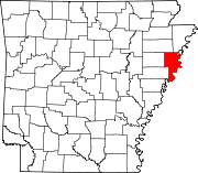
 Location of Crittenden County in Arkansas
This is a list of the National Register of Historic Places listings in Crittenden County, Arkansas.
This is intended to be a complete list of the properties and districts on the National Register of Historic Places in Crittenden County, Arkansas, United States. The locations of National Register properties and districts for which the latitude and longitude coordinates are included below, may be seen in a Google map.[1]
There are 16 properties and districts listed on the National Register in the county.
Contents: Counties in Arkansas Arkansas - Ashley - Baxter - Benton - Boone - Bradley - Calhoun - Carroll - Chicot - Clark - Clay - Cleburne - Cleveland - Columbia - Conway - Craighead - Crawford - Crittenden - Cross - Dallas - Desha - Drew - Faulkner - Franklin - Fulton - Garland - Grant - Greene - Hempstead - Hot Spring - Howard - Independence - Izard - Jackson - Jefferson - Johnson - Lafayette - Lawrence - Lee - Lincoln - Little River - Logan - Lonoke - Madison - Marion - Miller - Mississippi - Monroe - Montgomery - Nevada - Newton - Ouachita - Perry - Phillips - Pike - Poinsett - Polk - Pope - Prairie - Pulaski (Little Rock) - Randolph - St. Francis - Saline - Scott - Searcy - Sebastian - Sevier - Sharp - Stone - Union - Van Buren - Washington - White - Woodruff - Yell
-
- This National Park Service list is complete through NPS recent listings posted November 10, 2011.[2]
Current listings
[3] Landmark name [4] Image Date listed Location City or town Summary 1 Crittenden County Bank and Trust Company April 19, 1984 Military Road
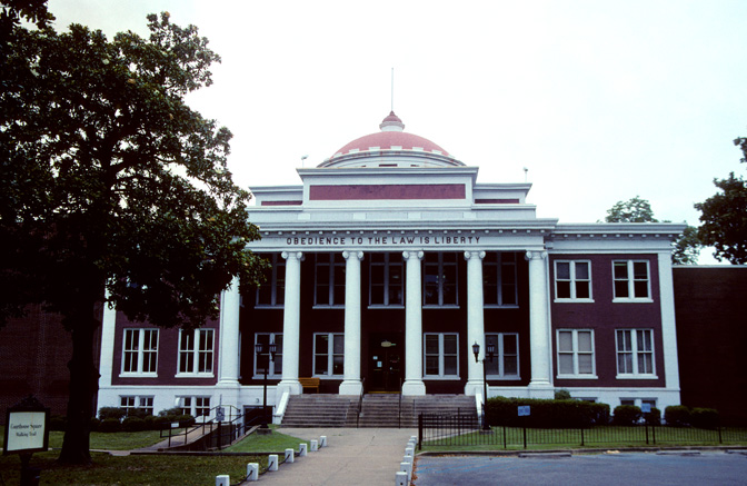
35°12′51″N 90°11′44″W / 35.214167°N 90.195556°WMarion 2 Crittenden County Courthouse 
August 3, 1977 85 Jackson Street
35°12′57″N 90°11′45″W / 35.215833°N 90.195833°WMarion 3 Dabbs Store 
May 17, 1982 1320 South Avalon
35°07′47″N 90°11′36″W / 35.129722°N 90.193333°WWest Memphis 5 Hamilton Apartments 
June 3, 1998 113 West Danner Street
35°09′00″N 90°11′08″W / 35.15°N 90.185556°WWest Memphis 6 Highway A-7, Gilmore to Turrell May 12, 2009 Old U.S. Route 63 between Acwin Street in Gilmore and ditch No. 2 in Turrell
35°24′35″N 90°16′43″W / 35.409747°N 90.278536°WGilmore 7 Lawrie House 
March 28, 1996 600 North 7th Street
35°09′11″N 90°10′36″W / 35.153056°N 90.176667°WWest Memphis 8 Marion Colored High School March 23, 1995 West of Highway 77
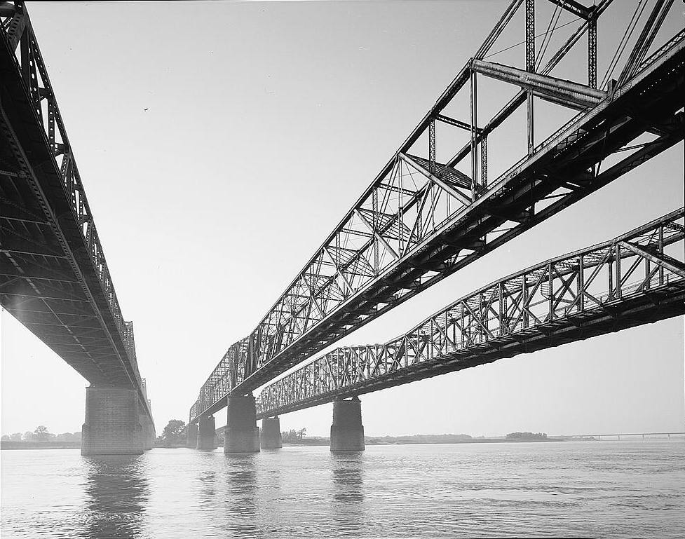
35°13′17″N 90°12′05″W / 35.221389°N 90.201389°WSunset 9 Memphis and Arkansas Bridge 
February 16, 2001 U.S. Route 55
35°07′47″N 90°04′45″W / 35.129722°N 90.079167°WWest Memphis 10 Missouri Pacific Depot 
March 6, 1986 Main and Commerce Streets
35°16′10″N 90°27′59″W / 35.269444°N 90.466389°WEarle Currently the Crittenden County Museum 4 Old Earle High School September 27, 2003 Junction of Ruth Street and High Second Street (U.S. Route 64 Business)
35°16′15″N 90°28′17″W / 35.270833°N 90.471389°WEarle 11 Old Turrell City Hall September 19, 2007 160 Eureka Street
35°22′42″N 90°15′21″W / 35.378333°N 90.255833°WTurrell 12 Riverside Speedway January 21, 2010 151 Legion Road
35°08′44″N 90°08′02″W / 35.145511°N 90.133858°WWest Memphis 13 George Berry Washington Memorial August 11, 1994 Highway 149, north of Earle
35°17′50″N 90°28′01″W / 35.297222°N 90.466944°WEarle 14 West Memphis City Hall 
July 8, 2010 100 Court Street
35°08′43″N 90°11′09″W / 35.145278°N 90.185833°WWest Memphis 15 West Memphis Commercial Historic District 
July 24, 2008 700, 800, and 900 blocks of East Broadway
35°08′48″N 90°10′26″W / 35.146539°N 90.173967°WWest Memphis 16 Wilson Power and Light Company Ice Plant January 21, 2010 120 East Broadway
35°08′48″N 90°11′05″W / 35.146536°N 90.184631°WWest Memphis See also
- List of National Historic Landmarks in Arkansas
- National Register of Historic Places listings in Arkansas
References
- ^ The latitude and longitude information provided in this table was derived originally from the National Register Information System, which has been found to be fairly accurate for about 99% of listings. For about 1% of NRIS original coordinates, experience has shown that one or both coordinates are typos or otherwise extremely far off; some corrections may have been made. A more subtle problem causes many locations to be off by up to 150 yards, depending on location in the country: most NRIS coordinates were derived from tracing out latitude and longitudes off of USGS topographical quadrant maps created under the North American Datum of 1927, which differs from the current, highly accurate WGS84 GPS system used by Google maps. Chicago is about right, but NRIS longitudes in Washington are higher by about 4.5 seconds, and are lower by about 2.0 seconds in Maine. Latitudes differ by about 1.0 second in Florida. Some locations in this table may have been corrected to current GPS standards.
- ^ "National Register of Historic Places: Weekly List Actions". National Park Service, United States Department of the Interior. Retrieved on November 10, 2011.
- ^ Numbers represent an ordering by significant words. Various colorings, defined here, differentiate National Historic Landmark sites and National Register of Historic Places Districts from other NRHP buildings, structures, sites or objects.
- ^ "National Register Information System". National Register of Historic Places. National Park Service. . http://nrhp.focus.nps.gov/natreg/docs/All_Data.html.
U.S. National Register of Historic Places Topics Lists by states Alabama • Alaska • Arizona • Arkansas • California • Colorado • Connecticut • Delaware • Florida • Georgia • Hawaii • Idaho • Illinois • Indiana • Iowa • Kansas • Kentucky • Louisiana • Maine • Maryland • Massachusetts • Michigan • Minnesota • Mississippi • Missouri • Montana • Nebraska • Nevada • New Hampshire • New Jersey • New Mexico • New York • North Carolina • North Dakota • Ohio • Oklahoma • Oregon • Pennsylvania • Rhode Island • South Carolina • South Dakota • Tennessee • Texas • Utah • Vermont • Virginia • Washington • West Virginia • Wisconsin • WyomingLists by territories Lists by associated states Other Municipalities and communities of Crittenden County, Arkansas Cities Clarkedale | Earle | Marion | Sunset | Turrell | West Memphis
Towns Anthonyville | Crawfordsville | Edmondson | Gilmore | Horseshoe Lake | Jennette | Jericho
Unincorporated
communitiesAmanca | Blanton | Booker | Brice | Browns | Bruins | Chatfield | Cunningham Corner | Dixie | Ebony | Gaililee | Galet | Gavin | Grassy Lake Bottom | Harvard Yard | Heafer | Highland Farm | James Mill | Julius | Kate | Lambethville | Lansing | Lehi | Mallory Spur | Meneshea | Midway Corner | Miller | Nintey-six Corner | Norvell | Patoka | Pickney | Quarles | Redman Point | Riceville | Seyppel | Shannonville | st. Claire | Stacy | Three-Forks | Topaz | Twist | Vincent | Waverly
Categories:- Crittenden County, Arkansas
- National Register of Historic Places in Arkansas by county
-


Wikimedia Foundation. 2010.