- Cunningham Corner, Arkansas
-
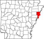
Cunningham Corner, Arkansas — Unincorporated community — Cunningham Corner's position in Arkansas. Coordinates: 35°11′30″N 90°17′30″W / 35.19167°N 90.29167°WCoordinates: 35°11′30″N 90°17′30″W / 35.19167°N 90.29167°W Country  United States
State  Arkansas
County Crittenden Township Jackson Elevation 66 m (217 ft) Time zone Central (CST) (UTC-6) - Summer (DST) CDT (UTC-5) Area code(s) 870 GNIS feature ID 67798 U.S. Geological Survey Geographic Names Information System: Cunningham Corner, Arkansas Cunningham Corner, Arkansas (formerly Cunningham's Corner, Arkansas) is an unincorporated community in Jackson Township, Crittenden County, Arkansas, United States.[1] It is located on Highway 147 where Highway 128 terminates at the West Memphis city limits.[2]
References
- ^ "Feature Detail Report for: Cunningham Corner, Arkansas." USGS. U.S. Geological Survey Geographic Names Information System: Cunningham Corner, Arkansas Retrieved November 10, 2011.
- ^ DeLorme. Arkansas Atlas and Gazetteer (Map) (Second ed.). Section 45.
Municipalities and communities of Crittenden County, Arkansas County seat: Marion Cities Clarkedale | Earle | Marion | Sunset | Turrell | West Memphis
Towns Anthonyville | Crawfordsville | Edmondson | Gilmore | Horseshoe Lake | Jennette | Jericho
Unincorporated
communitiesAmanca | Blanton | Booker | Brice | Browns | Bruins | Chatfield | Cunningham Corner | Dixie | Ebony | Gaililee | Galet | Gavin | Grassy Lake Bottom | Harvard Yard | Heafer | Highland Farm | James Mill | Julius | Kate | Lambethville | Lansing | Lehi | Mallory Spur | Meneshea | Midway Corner | Miller | Nintey-six Corner | Norvell | Patoka | Pickney | Quarles | Redman Point | Riceville | Seyppel | Shannonville | st. Claire | Stacy | Three-Forks | Topaz | Twist | Vincent | Waverly
Categories:- Arkansas geography stubs
- Populated places in Crittenden County, Arkansas
- Unincorporated communities in Arkansas
Wikimedia Foundation. 2010.


