- National Register of Historic Places listings in Bowie County, Texas
-
List of Registered Historic Places in Bee County, Texas
This is intended to be a complete list of properties and districts listed on the National Register of Historic Places in Bowie County, Texas. The locations of National Register properties and districts (at least for all showing latitude and longitude coordinates below) may be seen in a Google map by clicking on "Map of all coordinates".[1]
-
- This National Park Service list is complete through NPS recent listings posted November 10, 2011.[2]
[3] Landmark name [4] Image Date listed Location City or town Summary 1 Bowie County Jail November 16, 1977 Public Sq.
33°26′32″N 94°25′18″W / 33.442222°N 94.421667°WBoston 2 Draughn-Moore House June 29, 1976 420 Pine St.
33°25′27″N 94°02′39″W / 33.424167°N 94.044167°WTexarkana 3 Earl-Rochelle House July 1, 1999 1920 Magnolia St.
33°26′08″N 94°02′37″W / 33.435556°N 94.043611°WTexarkana 4 Garland Community School Teacherage March 6, 2002 TX 2, 2.5 mi. W of Dekalb
33°30′58″N 94°40′11″W / 33.516111°N 94.669722°WDekalb 5 Hotel McCartney September 6, 1979 Corner of Front and Main Streets
33°25′13″N 94°02′35″W / 33.420278°N 94.043056°WTexarkana 6 Offenhauser Insurance Building February 25, 1971 State Line Ave. and 3rd St.
33°25′19″N 94°02′35″W / 33.421944°N 94.043056°WTexarkana 7 Rialto Building June 17, 1982 317 State Line Ave.
33°25′24″N 94°03′14″W / 33.423333°N 94.053889°WTexarkana 8 Roseborough Lake Site July 6, 1976 Address Restricted Texarkana 9 Saenger Theater July 12, 1978 219 Main St.
33°25′17″N 94°02′41″W / 33.421389°N 94.044722°WTexarkana 10 Texarkana Phase Archeological District August 14, 1973 Address Restricted Texarkana 11 Texarkana Union Station November 19, 1978 State Line and Front St.
33°25′12″N 94°02′33″W / 33.42°N 94.0425°WTexarkana Extends into Miller County, Arkansas 12 Texarkana US Post Office and Courthouse 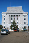
March 24, 2000 5th St. and State Line Ave.
33°25′30″N 94°02′34″W / 33.425°N 94.042778°WTexarkana Extends into Miller County, Arkansas 13 Tilson Mounds-Summerhill Lake Place (41BW14) January 16, 1987 Address Restricted Texarkana 14 Whitaker House November 7, 1979 517 Whitaker St.
33°25′19″N 94°03′25″W / 33.421944°N 94.056944°WTexarkana See also
- Registered Historic Places in Texas, Counties A-C
References
- ^ The latitude and longitude information provided in this table was derived originally from the National Register Information System, which has been found to be fairly accurate for about 99% of listings. For about 1% of NRIS original coordinates, experience has shown that one or both coordinates are typos or otherwise extremely far off; some corrections may have been made. A more subtle problem causes many locations to be off by up to 150 yards, depending on location in the country: most NRIS coordinates were derived from tracing out latitude and longitudes off of USGS topographical quadrant maps created under the North American Datum of 1927, which differs from the current, highly accurate WGS84 GPS system used by Google maps. Chicago is about right, but NRIS longitudes in Washington are higher by about 4.5 seconds, and are lower by about 2.0 seconds in Maine. Latitudes differ by about 1.0 second in Florida. Some locations in this table may have been corrected to current GPS standards.
- ^ "National Register of Historic Places: Weekly List Actions". National Park Service, United States Department of the Interior. Retrieved on November 10, 2011.
- ^ Numbers represent an ordering by significant words. Various colorings, defined here, differentiate National Historic Landmark sites and National Register of Historic Places Districts from other NRHP buildings, structures, sites or objects.
- ^ "National Register Information System". National Register of Historic Places. National Park Service. . http://nrhp.focus.nps.gov/natreg/docs/All_Data.html.
U.S. National Register of Historic Places Topics Lists by states Alabama • Alaska • Arizona • Arkansas • California • Colorado • Connecticut • Delaware • Florida • Georgia • Hawaii • Idaho • Illinois • Indiana • Iowa • Kansas • Kentucky • Louisiana • Maine • Maryland • Massachusetts • Michigan • Minnesota • Mississippi • Missouri • Montana • Nebraska • Nevada • New Hampshire • New Jersey • New Mexico • New York • North Carolina • North Dakota • Ohio • Oklahoma • Oregon • Pennsylvania • Rhode Island • South Carolina • South Dakota • Tennessee • Texas • Utah • Vermont • Virginia • Washington • West Virginia • Wisconsin • WyomingLists by territories Lists by associated states Other Categories:- Bowie County, Texas
- National Register of Historic Places in Texas
- Buildings and structures in Bowie County, Texas
-

Wikimedia Foundation. 2010.