- McGehee, Arkansas
-
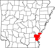
McGehee, Arkansas — City — 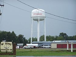 Location in Desha County and the state of Arkansas
Coordinates: 33°37′32″N 91°23′40″W / 33.62556°N 91.39444°WCoordinates: 33°37′32″N 91°23′40″W / 33.62556°N 91.39444°W Country United States State Arkansas County Desha Area – Total 6.4 sq mi (16.6 km2) – Land 6.4 sq mi (16.6 km2) – Water 0 sq mi (0 km2) Elevation 144 ft (44 m) Population (2010) – Total 4,219 – Density 658.3/sq mi (254.2/km2) Time zone Central (CST) (UTC-6) – Summer (DST) CDT (UTC-5) ZIP codes 71654, 71666 Area code(s) 870 FIPS code 05-42770 GNIS feature ID 0058148 McGehee is a city in Desha County, Arkansas, United States. The population was 4,219 at the 2010 census.[1]
Contents
History
The history of the city of McGehee and the history of the railroad through McGehee are intricately interwoven. The history of the railroad dates back to 1870 when a railroad was constructed from Pine Bluff southeast through Varner, to Chicot.
In April 1923, the Gulf Coast Lines and the International-Great Northern were acquired, forming the Missouri Pacific Lines.
Important in the history of the town of McGehee is the McGehee family which came to the area from Alabama in 1857. Benjamin McGehee, his wife, Sarah, a son, Abner, and daughters Laura and Mary settled on land that is now a part of McGehee. Abner McGehee, son of Benjamin and Sarah McGehee, purchased 240 acres (0.97 km2) of land on July 1, 1876, on which the town of McGehee was later to be located.
When the railroad came into McGehee in 1878 and continued south and southwest, people began to move into the area. Abner McGehee constructed a large commissary building and entered the mercantile business to accommodate the new arrivals.
One of the first buildings in the area was a sawmill. The lumber cut in this mill was used to build shotgun-type rent houses.
A post office was established in the McGehee commissary, and in 1879 Abner McGehee became the first postmaster. The post office was named McGehee and served between 400 and 500 people.
An order of incorporation was signed March 5, 1906. The first meeting of the town council was held July 21, 1906.
During World War II, the outskirts of McGehee was the site of an American concentration camp used to house Japanese and Japanese-American civilians who had previously lived on the U.S. West Coast.
Today the economy of the area is largely dependent upon agriculture. The railroad has been largely replaced by the trucking industry which hauls farm products from the gins and grain bins of the area to their destination. From a population of 400 in 1879, McGehee has grown into a community of about 5,000 citizens. Port facilities on the Mississippi River are being developed, and the present highway system is rebuilt to accommodate increased traffic.
Geography
McGehee is located at 33°37′32″N 91°23′40″W / 33.62556°N 91.39444°W (33.625426, -91.394330)[2].
According to the United States Census Bureau, the city has a total area of 6.4 square miles (17 km2), all land.
Demographics
As of the census[3] of 2000, there were 4,570 people, 1,836 households, and 1,259 families residing in the city. The population density was 711.7 people per square mile (274.8/km²). There were 2,044 housing units at an average density of 318.3 per square mile (122.9/km²). The racial makeup of the city was 56.72% White, 41.51% Black or African American, 0.57% Native American, 0.24% Asian, 0.04% Pacific Islander, 0.22% from other races, and 0.70% from two or more races. 1.49% of the population were Hispanic or Latino of any race.
There were 1,836 households out of which 34.0% had children under the age of 18 living with them, 41.7% were married couples living together, 22.9% had a female householder with no husband present, and 31.4% were non-families. 29.4% of all households were made up of individuals and 13.9% had someone living alone who was 65 years of age or older. The average household size was 2.44 and the average family size was 2.99.
In the city the population was spread out with 28.5% under the age of 18, 8.8% from 18 to 24, 25.0% from 25 to 44, 21.3% from 45 to 64, and 16.4% who were 65 years of age or older. The median age was 36 years. For every 100 females there were 82.2 males. For every 100 females age 18 and over, there were 76.1 males.
The median income for a household in the city was $21,909, and the median income for a family was $25,270. Males had a median income of $31,429 versus $19,464 for females. The per capita income for the city was $14,191. About 26.7% of families and 30.0% of the population were below the poverty line, including 42.2% of those under age 18 and 23.6% of those age 65 or over.
Government and infrastructure
The United States Postal Service operates the McGehee Post Office.[4]
Education
The McGehee School District operates public schools.
References
- ^ "Race, Hispanic or Latino, Age, and Housing Occupancy: 2010 Census Redistricting Data (Public Law 94-171) Summary File (QT-PL), McGehee city, Arkansas". U.S. Census Bureau, American FactFinder 2. http://factfinder2.census.gov. Retrieved August 15, 2011.
- ^ "US Gazetteer files: 2010, 2000, and 1990". United States Census Bureau. 2011-02-12. http://www.census.gov/geo/www/gazetteer/gazette.html. Retrieved 2011-04-23.
- ^ "American FactFinder". United States Census Bureau. http://factfinder.census.gov. Retrieved 2008-01-31.
- ^ "Post Office™ Location - MC GEHEE." United States Postal Service. Retrieved on July 27, 2011.
External links
- History of McGehee's Jewish community (from the Institute of Southern Jewish Life)
Municipalities and communities of Desha County, Arkansas Cities Arkansas City | Dumas | McGehee | Mitchellville | Tillar‡ | Watson
Town Unincorporated
communitiesBack Gate | Halley | Kelso | Pea Ridge | Pickens | Rohwer | Snow Lake | Trippe Junction
Ghost towns Napoleon | Wellington
Footnotes ‡This populated place also has portions in an adjacent county or counties
Categories:- Populated places in Desha County, Arkansas
- Cities in Arkansas
- Populated places established in 1878


Wikimedia Foundation. 2010.