- Driver, Arkansas
-
Driver, Arkansas — Unincorporated community — 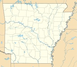
 Driver, Arkansas
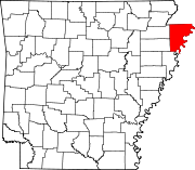
Coordinates: 35°36′44″N 90°00′43″W / 35.61222°N 90.01194°WCoordinates: 35°36′44″N 90°00′43″W / 35.61222°N 90.01194°W Country United States State Arkansas County Mississippi Elevation 236 ft (72 m) Time zone Central (CST) (UTC-6) - Summer (DST) CDT (UTC-5) ZIP code 72329 Area code(s) 870 GNIS feature ID 57678[1] Driver is an unincorporated community in Mississippi County, Arkansas, United States. Driver is located at the intersection of U.S. Route 61 and Arkansas Highway 119 3.5 miles (5.6 km) north-northeast of Wilson. Driver has a post office with ZIP code 72329.[2]
References
Municipalities and communities of Mississippi County, Arkansas County seats: Blytheville and Osceola Cities Blytheville | Gosnell | Joiner | Keiser | Leachville | Manila | Osceola
Towns Unincorporated
communitiesArkmo‡ | Athelstan | Creamery Package | Denwood | Dimple | Driver | Floodway | Frenchmans Bayou | Poplar Corner | Turner | West Ridge
Footnotes ‡This populated place also has portions in an adjacent county or counties
Categories:- Populated places in Mississippi County, Arkansas
- Unincorporated communities in Arkansas
- Arkansas geography stubs


Wikimedia Foundation. 2010.