- Creamery Package, Arkansas
-
Creamery Package, Arkansas — Unincorporated community — Creamery Package's position in Arkansas.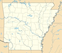
 Creamery Package, Arkansas
Coordinates: 35°33′12″N 90°9′53″W / 35.55333°N 90.16472°WCoordinates: 35°33′12″N 90°9′53″W / 35.55333°N 90.16472°W Country  United States
State  Arkansas
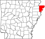
County Mississippi Township Scott Elevation 71 m (233 ft) Time zone Central (CST) (UTC-6) - Summer (DST) CDT (UTC-5) GNIS feature ID 76703 U.S. Geological Survey Geographic Names Information System: Creamery Package, Arkansas Creamery Package (formerly Hitt) is an unincorporated community in Scott Township, Mississippi County, Arkansas, United States.[1] It is north of Interstate 55 exit 36 and southeast of Dyess.[2]
References
- ^ "Feature Detail Report for: Harmon, Arkansas." USGS. U.S. Geological Survey Geographic Names Information System: Creamery Package, Arkansas Retrieved June 16, 2011.
- ^ DeLorme. Arkansas Atlas and Gazetteer (Map) (Second ed.). Section 37.
Municipalities and communities of Mississippi County, Arkansas County seats: Blytheville and Osceola Cities Blytheville | Gosnell | Joiner | Keiser | Leachville | Manila | Osceola
Towns Unincorporated
communitiesFootnotes ‡This populated place also has portions in an adjacent county or counties
Categories:- Populated places in Mississippi County, Arkansas
- Unincorporated communities in Arkansas
- Arkansas geography stubs


Wikimedia Foundation. 2010.