- Covington County, Mississippi
-
Covington County, Mississippi 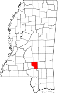
Location in the state of Mississippi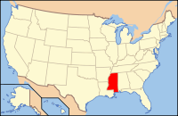
Mississippi's location in the U.S.Founded 1819 Seat Collins Largest city Collins Area
- Total
- Land
- Water
414.94 sq mi (1,075 km²)
413.79 sq mi (1,072 km²)
1.15 sq mi (3 km²), 0.28%Population
- (2010)
- Density
19,568
47/sq mi (18/km²)Covington County is a county located in the U.S. state of Mississippi. As of 2010, the population was 19,568. Its county seat is Collins[1]. Covington County is named for U.S. Army officer and Congressman Leonard Covington.
Contents
History
Covington County was established on January 5, 1819, less than two years after Mississippi earned statehood into the Union. The county was one of the first counties established out of the vast non-agricultural lands in the more eastern part of the state. Covington was originally cut out of Lawrence and Wayne Counties, and encompassed what is now Jefferson Davis, Covington, and Jones Counties.
In 1823, part of Covington County became Bainbridge County, most likely named after William Bainbridge, who became an American naval hero during the War of 1812. The next year, in 1824, the Mississippi legislature did away with Bainbridge County, giving its lands back to Covington County.
Geography
According to the 2000 census, the county has a total area of 414.94 square miles (1,074.7 km2), of which 413.79 square miles (1,071.7 km2) (or 99.72%) is land and 1.15 square miles (3.0 km2) (or 0.28%) is water.[2]
Major highways
 U.S. Highway 49
 U.S. Highway 84
Covington County is crossed both north-to-south and east-to-west by four-laned state highways. Highway 49, which runs north-south through all three municipalities, is the lifeblood of Covington County. Highway 49, commonly known as Mississippi's Main Street, connects the state's three largest cities—Jackson, Gulport, and Hattiesburg—to Covington County as well as cities such as Wiggins, Magee, Clinton, and Yazoo City. Highway 49 brings to Covington County thousands each day.
Highway 84 cuts across Covington County east to west, and runs through the City of Collins. Highway 84 connects the mid-size cities of Laurel, Brookhaven, and Natchez to Covington County, and brings hundreds of people to the county each day.
Minor highways
- Mississippi Highway 35 (Mt. Olive, Mize, Raleigh)
- Mississippi Highway 37 (Collins to Taylorsville)
- Mississippi Highway 184 (Collins)
- Mississippi Highway 588 (Collins to Ellisville)
- Mississippi Highway 598 (Sanford)
- Mississippi Highway 589 (Seminary, Sumrall, Purvis)
- Mississippi Highway 590 (Seminary to Ellisville)
- Mississippi Highway 532 (Mt. Olive to Hopewell)
- Mississippi Highway 535 (Seminary to Collins)
A network of two-laned highways also run through Covington County, connecting big cities and small communities alike. Main Street Collins is Highway 184, formerly Highway 84. Main Street Seminary is Highway 590.
Adjacent counties
- Smith County (north)
- Jones County (east)
- Forrest County (southeast)
- Lamar County (south)
- Jefferson Davis County (west)
- Simpson County (northwest)

Simpson County Smith County Jefferson Davis County 
Jones County  Covington County, Mississippi

Lamar County Forrest County Demographics
2010 Census
As of the most recent census, 2010, the population of Covington County is 19,568, only a slight increase from 2000. Racially, the population was distributed with 62.7% being White, 34.7% Black/African American, 1.9% Hispanic/Latino, 0.2% Asian, 0.1% American Indian/Alaskan Native, and 0.7% claiming multiple races.
By age category, Covington County residents are dispersed as follows: 29.1% are under the age of twenty; 23.8% are between the ages of twenty and forty; 32% are between the ages of forty-one and sixty-five; and 15.1% are over age sixty-five. The average age is 37.6 years. By gender, 48.6% are men and 51.4% are women.
There are 8,496 houseing units in the county. Of these, 47.1% are inhabited by husband/wife families; 5% by a man with no wife present; 18.1% by a woman with no husband present; and 29.7% by non-families. The average household size is 2.60, and the average family size is 3.14.
Historical populations Census Pop. %± 1820 2,230 — 1830 2,551 14.4% 1840 2,717 6.5% 1850 3,338 22.9% 1860 4,408 32.1% 1870 4,753 7.8% 1880 5,993 26.1% 1890 8,299 38.5% 1900 13,076 57.6% 1910 16,909 29.3% 1920 14,869 −12.1% 1930 15,028 1.1% 1940 17,030 13.3% 1950 16,036 −5.8% 1960 13,637 −15.0% 1970 14,002 2.7% 1980 15,927 13.7% 1990 16,527 3.8% 2000 19,407 17.4% 2010 19,568 0.8% MS Counties 1900-1990
GeoHive - 2000 & 2010 statistics2000 Census
As of the census[3] of 2000, there were 19,407 people, 7,126 households, and 5,280 families residing in the county. The population density was 47 people per square mile (18/km²). There were 8,083 housing units at an average density of 20 per square mile (8/km²). The racial makeup of the county was 63.42% White, 35.61% Black or African American, 0.13% Native American, 0.12% Asian, 0.02% Pacific Islander, 0.15% from other races, and 0.56% from two or more races. 0.80% of the population were Hispanic or Latino of any race.
There were 7,126 households out of which 36.60% had children under the age of 18 living with them, 51.50% were married couples living together, 17.20% had a female householder with no husband present, and 25.90% were non-families. 23.60% of all households were made up of individuals and 10.70% had someone living alone who was 65 years of age or older. The average household size was 2.68 and the average family size was 3.16.
In the county the population was spread out with 28.80% under the age of 18, 9.60% from 18 to 24, 27.30% from 25 to 44, 21.20% from 45 to 64, and 13.00% who were 65 years of age or older. The median age was 34 years. For every 100 females there were 92.60 males. For every 100 females age 18 and over, there were 90.40 males.
The median income for a household in the county was $26,669, and the median income for a family was $31,264. Males had a median income of $26,611 versus $18,371 for females. The per capita income for the county was $14,506. About 18.70% of families and 23.50% of the population were below the poverty line, including 31.60% of those under age 18 and 20.30% of those age 65 or over.
Communities
Cities
Towns
Unincorporated communities
- Lux
- Sanford
- Eminence
- Lone Star
- Ora
- Williamsburg
- Sunset
- Leaf River
- Dry Creek
- Salem
- Rock Hill
- Okahay
See also
Notable natives
- Dana Andrews, actor and former president of the Screen Actors Guild
- Steve McNair, former NFL quarterback
- Gerald McRaney, television actor
- Dale Houston, singer
References
- ^ "Find a County". National Association of Counties. http://www.naco.org/Counties/Pages/FindACounty.aspx. Retrieved 2011-06-07.
- ^ "Census 2000 U.S. Gazetteer Files: Counties". United States Census. http://www.census.gov/tiger/tms/gazetteer/county2k.txt. Retrieved 2011-02-13.
- ^ "American FactFinder". United States Census Bureau. http://factfinder.census.gov. Retrieved 2008-01-31.
Coordinates: 31°38′N 89°33′W / 31.63°N 89.55°W
Municipalities and communities of Covington County, Mississippi Cities 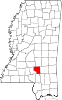
Towns Unincorporated
communitiesHopewell | Ora | Sanford
Categories:- Mississippi counties
- Covington County, Mississippi


Wikimedia Foundation. 2010.