- Cedars of Lebanon State Park
Infobox park
park=Cedars of Lebanon State Park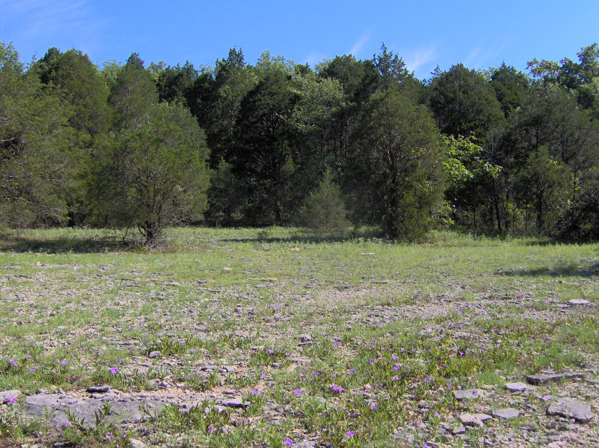
image size=250px
caption=cedar glade
type=Tennessee State Park
location=Lebanon, Tennessee
coordinates=
size=convert|900|acre|km2
opened=
operator=Tennessee Department of Environment and Conservation
annual visitors=
status=Cedars of Lebanon State Park is a state park in
Wilson County, Tennessee , in the southeastern United States. It consists of convert|900|acre|km2 situated amidst the convert|9420|acre|km2|sing=on Cedars of Lebanon State Forest. The park and forest are approximately convert|10|mi|km south ofLebanon, Tennessee .Cedars of Lebanon State Forest is known for its
cedar glade s, a unique type of ecosystem that has adapted to the thin (or nonexistant) soil layers that often occur in the eastern Central Basin. These glades are typically flanked by thick stands of red cedar, a type ofjuniper tree that can survive in soil layers too thin to support most large wooded plants. The presence of the red cedar in the basin reminded the region's early Euro-American settlers of the Lebanese cedar forests of Biblical fame.Geographical setting
Cedars of Lebanon State Park is situated in the eastern Central Basin approximately convert|15|mi|km west of the eastern
Highland Rim , convert|15|mi|km east of Nashville and convert|20|mi|km north of Murfreesboro.U.S. Route 231 , which runs north-to-south, splits the state forest into eastern and western sections. The state park (i.e., the developed area) is located in the eastern section along Cedar Forest Road. The western section consists of an undeveloped state forest. convert|1043|acre|km2 of the western section has been classifed as a state natural area. [" [http://www.state.tn.us/environment/na/natareas/cedars/ Cedars of Lebanon State Forest] ." Retrieved: 12 August 2008.]Like most karst areas, Cedars of Lebanon State Forest is drained in large part by underground streams. The water in the forest probably ends up in nearby streams, such as Hurricane Creek. [Charles Wilson, Jr., "Geology of Cedars of Lebanon State Park and Forest and Vicinity in Wilson County, Tennessee" (Tennessee Division of Geology, 1980), 9.] These streams empty into the Stones River's
J. Percy Priest Lake impoundment, which is located just a few miles to the west.Natural information
Cedars of Lebanon State Forest is underlain by
Ordovician period limestone, formed roughly 460 million years ago fromcalcareous ooze deposited by a primordial sea that once covered Middle Tennessee. Weathering of this rock has led to the creation ofkarst formations such as joints, underground streams, caves, andsinkhole s, which are common throughout the park and forest. [Charles Wilson, 18.] The forest is located in a flat section of the Central Basin characterized by thin soil layers where the limestone bedrock is often exposed. [Information obtained from interpretive signs at Cedars of Lebanon State Park, 9 August 2008.]Cedar glade communities have adapted the basin's harsh barrens, where the soil is too thin to support most plant types, especially large wooded plants. The glades are typically open areas resembling rock or gravel-strewn meadows. Most glades include small areas of bare rock where nothing grows, gravelly areas where only grasses grow, and patches of very thin soil that support shrubs and small red cedars. Cedar glades are typically surrounded by stands of red cedar known as cedar thickets. Beyond the cedar thickets, the soil is thick enough to support a hardwood forest consisting primarily of oak and hickory. [Information obtained from interpretive signs at Cedars of Lebanon State Park, 9 August 2008.]
The cedar glades of Cedars of Lebanon State Forest are home to 350 plant species, 29 of which are endemic to the cedar glades. Flowering plant species living in the glades include the endangered Tennessee Coneflower ("Echinacea tennesseensis"), the Prickly Pear cactus ("Opuntia humifusa"), Limestone flame flower ("Talinum calcaricum"), Gattinger's Prairie Clover ("
Dalea gattingeri"), Glade Phlox ("Phlox bifida"), and Nashville Breadroot ("Pediomelum subacaulis"). Nonflowering plants includereindeer moss and glade moss. Along with the red cedar, trees in the surrounding forest includewhite oak andshagbark hickory . Wildlife chiefly consists of rodents and birds. [Information obtained from interpretive signs at Cedars of Lebanon State Park, 9 August 2008.]History
Infobox nrhp
name =Cedars of Lebanon State Park Historic District
nrhp_type = hd
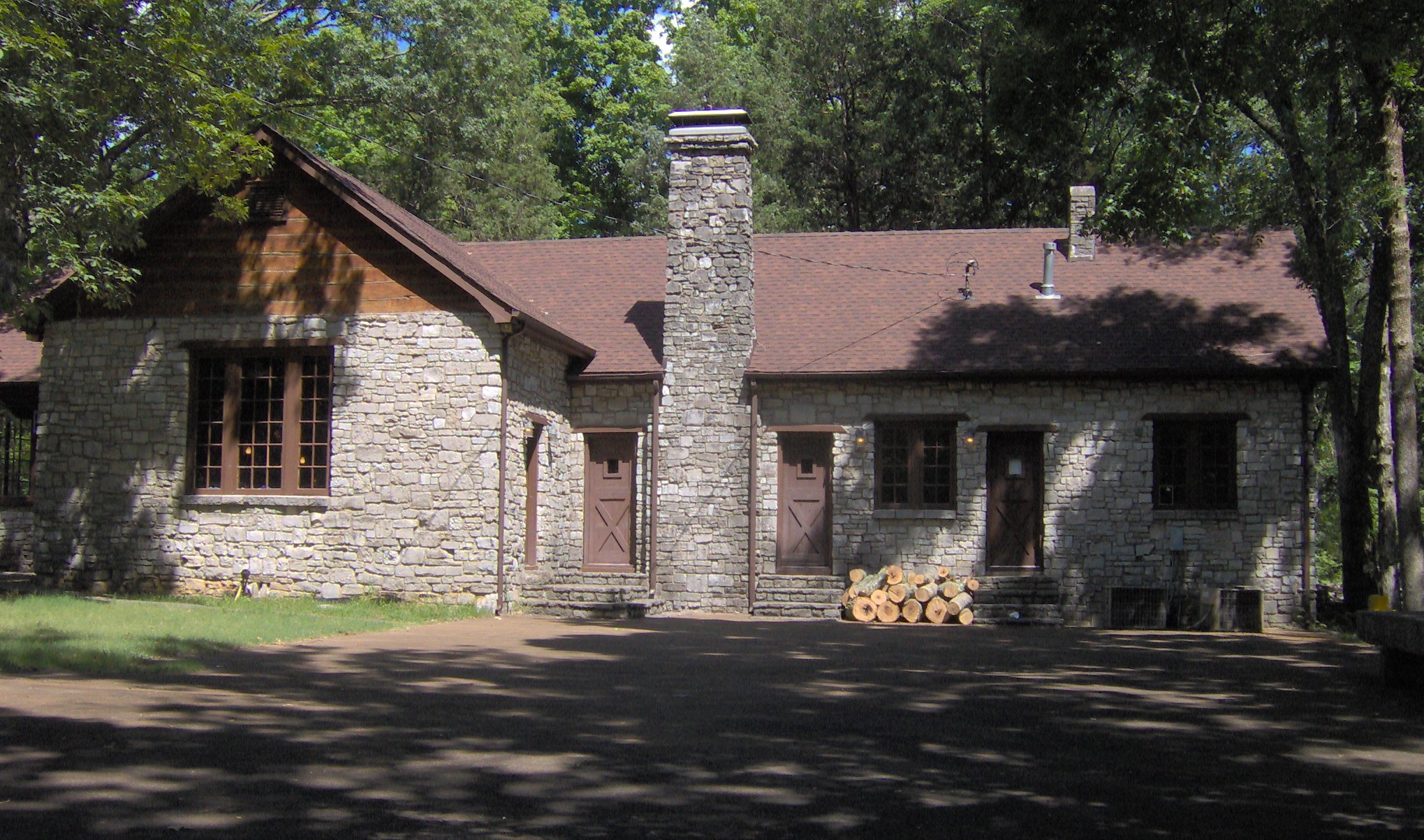
caption = Cedar Lodge
location =
nearest_city =Lebanon, Tennessee
lat_degrees =
lat_minutes =
lat_seconds =
lat_direction =
long_degrees =
long_minutes =
long_seconds =
long_direction =
area =
built = 1925-1949
architect =
architecture =
added = 1995
visitation_num =
visitation_year =
refnum = 95001274
mpsub =
governing_body = TDECThe earliest Euro-American settlers arrived in Wilson County in the late 1790s. The city of Lebanon, established in 1802, was named after the abundance of red cedar in the area. The settlers believed (mistakenly) that the red cedar stands were similar to the cedar forests of ancient Lebanon, which were harvested byPhoenicia n city-states and used in the construction of theTemple of Solomon . The first Wilson County courthouse and many other early structures in the county were constructed using red cedar logs. [James Drake, "An Historical Sketch of Wilson County, Tennessee" (Lebanon, Tenn.: The Press of the Democrat, 1976), 14. Originally published in 1879.]For much of the 19th century, the barren glades were largely devoid of human habitation, with the exception of a few small farms. In an 1879 essay on the history of Wilson County, James Drake described the various soil types in the county, which included a "dark soil, peculiar to the cedar flats, the least desireable of any we have, and subject to drought, being usually near the rock." [Drake, 10.] The town of Gladeville was established in 1852 just west of the modern state forest boundaries and grew into a sizeable hamlet until the outbreak of the
American Civil War . [Drake, 16.]In the late 1800s and early 1900s, the high demand for lumber led to the harvesting of most of the forests in the Central Basin. Red cedar in particular was popular for use in the making of furniture, fence rails, and pencils. In the cedar flats of Wilson County, small farmers were struggling with depletion of the already-thin soil layer caused by poor farming tactics. In 1935, as part of the
New Deal , the federal government initiated a plan to resettle farmers living in badly eroded lands to allow the devastated forests to recover. As part of the Lebanon Cedar Forest Project, the federalResettlement Administration helped move the farmers in the cedar flats to new locations, and theWorks Project Administration constructed forestry and recreational facilities and planted thousands of red cedar seedlings. The work was supervised by theUnited States Forestry Service . "Lebanon Cedar Forest" officially opened in 1937, with local newspaper editor Dixon Merritt presiding over the opening ceremony. Although the land was managed by the Tennessee Department of Conservation, the federal government retained ownership until 1955. [" [http://www.state.tn.us/environment/parks/Cedars/pdf/history.pdf History of Cedars of Lebanon State Park] ." Retrieved: 13 August 2008.] [Sandy Suddarth, " [http://tennesseeencyclopedia.net/imagegallery.php?EntryID=C051 Cedars of Lebanon State Park] ." "The Tennessee Encyclopedia of History and Culture", 2002. Retrieved: 14 August 2008.]Botanists began noting the ecological importance of the cedar glades as early as 1901, when German-born doctor Augustin Gattinger (1825-1903) mentioned the glades in his book "The Flora of Tennessee and the Philosophy of Botany". Research conducted by
Elsie Quarterman ofVanderbilt University led to the forest's designation as a national natural landmark in 1973. [Information obtained from interpretive signs at Cedars of Lebanon State Park, 9 August 2008.] In 1995, Cedar Lodge and several other structures built by the WPA in the 1930s and 1940s were placed on theNational Register of Historic Places .The park today
Cedars of Lebanon State Park has 117 campsites, 11 picnic shelters, a swimming pool, convert|8|mi|km of hiking trails, a group lodge, and a meeting hall. A small museum, the Merritt Nature Center, displays some of the forest's natural features. The park also maintains a
disc golf course.The park's eight miles of hiking trails range in size from convert|0.5|mi|km to convert|5|mi|km. The convert|0.5|mi|km|sing=on Cedar Glades Trail, which begins at the park visitor center, is a self-guided interpretive trail that crosses several cedar glade habitats characteristic of glades found in the eastern basin. The convert|2|mi|km|sing=on Cedar Forest Trail, which begins near the junction of Cedar Forest Road and WPA Road, loops through a mixed oak-hickory and red cedar forest and passes several sizeable sinkholes and blockfields. The convert|0.5|mi|km|sing=on Dixon Merritt Trail begins behind the Merritt Nature Center and provides access to Jackson Cave. The convert|0.5|mi|km|sing=on Limestone Sinks Trail is another self-guided trail that passes several large limestone sinks. The convert|5|mi|km|sing=on Hidden Springs Trail, which starts near the picnic area, loops through multiple terrain types characteristic of the state forest, including a large limestone sink and associated dry streambed, several substantial cedar glades, and a dense stand of mixed red cedar and oak-hickory forest.
Jackson Cave is one of 18 known caves located in the state forest and the immediate vicinity. The cave's entrance is convert|30|ft|m wide and convert|4|ft|m high, and the cave corridor has an average width of convert|12|ft|m and an average height of convert|6|ft|m. The cave extends approximately convert|1000|ft|m from its entrance to a large pool of water. [Wilson, 14.]
Photo gallery

References
External links
* [http://www.state.tn.us/environment/parks/Cedars/ Cedars of Lebanon State Park] — official site
* [http://www.state.tn.us/environment/na/natareas/cedars/ Cedars of Lebanon State Forest State Natural Area] — official site
* [http://www.nature.nps.gov/nnl/Registry/USA_Map/States/Tennessee/NNL/CG/index.cfm Cedar Glades Natural Area] — National Park Service entry
Wikimedia Foundation. 2010.