- Cordell Hull Birthplace State Park
-
Cordell Hull Birthplace

Nearest city: Byrdstown, Tennessee Coordinates: 36°34′54″N 85°10′55″W / 36.58167°N 85.18194°WCoordinates: 36°34′54″N 85°10′55″W / 36.58167°N 85.18194°W Built: 1850-1874 Governing body: TDEC NRHP Reference#: 72001250 Added to NRHP: 1972 Cordell Hull Birthplace State Park is a state park in Pickett County, Tennessee, in the southeastern United States. Cordell Hull (1871–1955) served as U.S. Secretary of State under President Franklin Roosevelt and played a pivotal role in the creation of the United Nations in the mid-1940s.
Contents
Geographical setting
Cordell Hull Birthplace State Park is situated along the Highland Rim, a barren and hilly area where the Cumberland Plateau descends westward into the Central Basin. The site is approximately 4 miles (6.4 km) south of the Wolf River, 4 miles (6.4 km) north of the Obey River, and 7 miles (11 km) east of the confluence of these two rivers at Dale Hollow Lake. The park is located along Tennessee State Route 325 a few miles west of the road's junction with Tennessee State Route 111 at Byrdstown. The park is managed by the Tennessee Department of Environment and Conservation.
History and features[1]
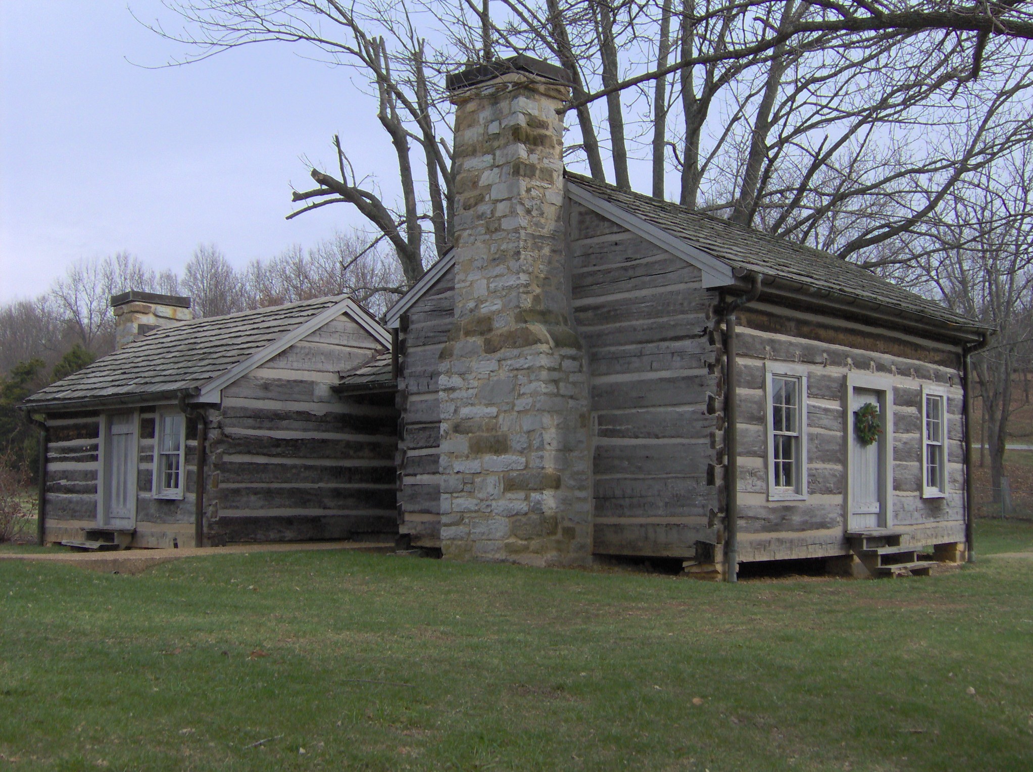
The 45 acre (.18 km²) site includes the refurbished log cabin where Hull was born in 1871 and a museum housing a number of Hull's personal items, including his 1945 Nobel Peace Prize. In 1953, the State of Tennessee purchased the cabin from the Amonett family and placed it in the hands of the Cordell Hull Birthplace and Memorial Association. The cabin was taken apart and rebuilt in the 1950s after its purchase by the state, and placed on the National Register of Historic Places in 1972. The museum was built in the 1960s.
In the 1970s and 1980s, oversight of the Hull Birthplace shifted between Pickett State Park to Standing Stone State Park, although the staff of both were deemed lacking in the necessary background for historical interpretation. After a report by Tennessee Technological University placed the structure on its endangered places list in 1986, the State of Tennessee and Pickett County improved the site's management. The cabin was again rebuilt in 1996 in hopes of reestablishing historical accuracy that had been ignored by the previous rebuilding. In 1997, Cordell Hull Birthplace State Park was created when the state legislature approved funding for a full-time staff for the site.
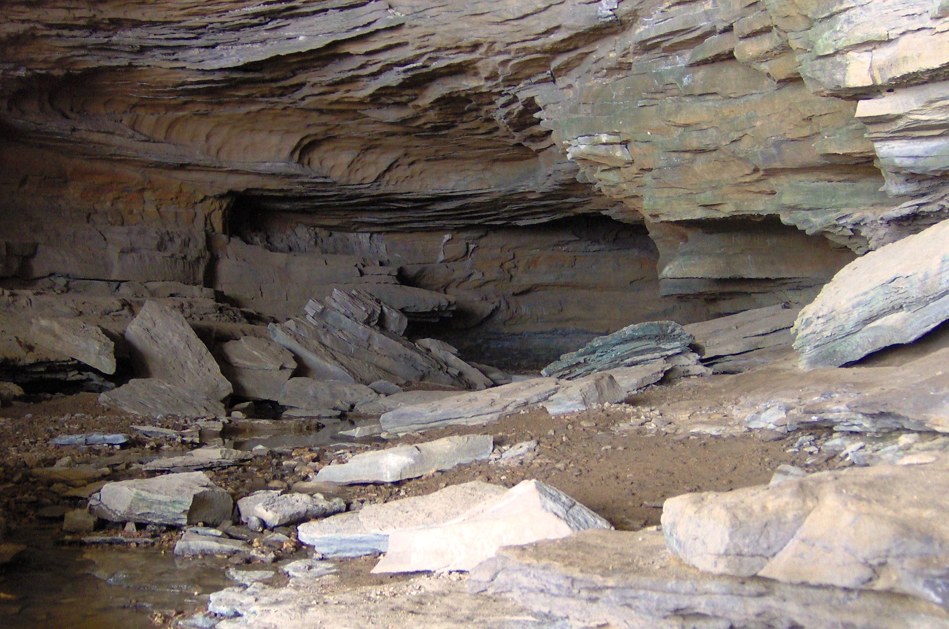
Bunkum Cave
 Bunkum Cave
One of many substantial caves located on the limestone-rich Highland Rim, Bunkum Cave is situated along the headwaters of Cove Creek, just south of the Cordell Hull Birthplace. The mouth of the cave is approximately 100 feet (30 m) wide and 30 feet (9.1 m) high (30m x 9m).[2] A 1992 survey of the cave by the Tennessee Division of Archaeology found evidence that the cave had been occupied during the Middle Woodland period (c. 1000 B.C. - 1000 A.D.). William Hull, Cordell's father, used the cave to house a moonshine still.[3] The state purchased the cave and the surrounding 29 acres (120,000 m2) in 2002 as an addition to the Cordell Hull Birthplace. Shortly thereafter, a 2.5-mile (4.0 km) loop trail was constructed to allow access to the cave's entrance. At present, a permit is required to explore the cave beyond its lighted area.
References
- ^ The information in this section obtained from: Tennessee Office of Strategic Planning, "The Cordell Hull Birthplace Area Management Plan," (December of 2002), 4-6.
- ^ Lana Rossi, "Cordell Hull and Bunkum Cave," 2002. Retrieved: 16 December 2007.
- ^ "The Cordell Hull Birthplace Area Management Plan" (2002), 14.
External links
- Cordell Hull Birthplace State Park — official site
- Cordell Hull Birthplace & Museum State Park - Friends of Cordell Hull, detailed information
- Article from Tennessee History for Kids
Categories:- Protected areas of Pickett County, Tennessee
- Tennessee state parks
- Houses on the National Register of Historic Places in Tennessee
- Museums in Pickett County, Tennessee
- Historic house museums in Tennessee
- Biographical museums in Tennessee
Wikimedia Foundation. 2010.