- North Carolina Highway 75
-
NC 75
Route information Maintained by NCDOT Length: 21 mi (34 km) Existed: 1934-35[1] – present Major junctions West end:  SC 75 near Rock Hill, SC
 NC 16 in Waxhaw, NC
East end: 
 NC 84 / NC 200 in Monroe, NC
Location Counties: Union Highway system ←  US 74
US 74US 76  →
→NC 75 is a twenty-one mile North Carolina state highway. Its entire length runs through Union County and it serves as the primary connector between the towns of Waxhaw, Mineral Springs, and Monroe. The route roughly parallels a CSX railline for its entire span.
Contents
Route description
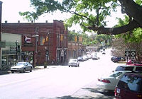 The terminus of NC 16 at NC 75 in Waxhaw
NC 75 officially ends in the west at the North Carolina-South Carolina state border. The road continues on into South Carolina as SC 75 for 13 miles (21 km) before that route ends at US 521/SC 5 at Van Wyck outside Rock Hill, South Carolina. From NC 75's western terminus, the route travels east six miles (10 km) to enter the town of Waxhaw. In downtown Waxhaw, NC 75 meets the southern terminus of NC 16 before continuing east, passing the Museum of the Waxhaws outside of town.
In the neighboring town of Mineral Springs, the route turns to continue on a northeasterly path. Ten miles after passing through Mineral Springs, NC 75 eastbound joins NC 84 eastbound through central Monroe. The two routes stay concurrent for one mile (West Franklin Street) to both terminate at NC 200 (Charlotte Avenue).
History
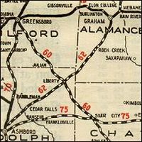 An early 1920s map of NC 75 in central North Carolina.
- Before 1927: NC 75 was originally the forerunner to US 15, US 64 and US 501. It ran from Lenoir eastward to the Virginia border.
- 1927: The western half of NC 75 was truncated to make way for US 64 and NC 90. The remaining NC 75 was then rerouted, moving the terminus to Rockingham.
- 1933: NC 75 is decommissioned, leaving US 15 to cover a majority of its alignment. Parts of the old highway are now NC 22, NC 27, NC 211 and NC 73.
- 1935: The 75 is recommissioned as a former segment of NC 25.
- Mid-1970s: A section between Waxhaw and Mineral Springs is rebuilt, shaving three miles (5 km) off the route's total length.
References
External links
Categories:- State highways in North Carolina
- Transportation in Union County, North Carolina


Wikimedia Foundation. 2010.