- North Carolina Highway 12
-
"NC 12" redirects here. NC 12 may also refer to North Carolina's 12th congressional district.
NC 12
Route information Maintained by NCDOT Length: 148 mi (238 km) Existed: 1962 – present Major junctions South end:  US 70 in Sealevel, NC
 US 64 / US 158 in Nags Head
US 158 in Kitty Hawk via Ocean BlvdNorth end: The North Beach Access Ramp North of Villages at Ocean Hill in Corolla, NC Location Counties: Currituck, Dare, Hyde, Carteret Highway system ←  NC 11
NC 11US 13  →
→NC 12 is a North Carolina state highway that traverses the northeastern shoreline of North Carolina, linking the islands of the Outer Banks. It is a popular route for visitors touring the Outer Banks. Most sections of NC 12 are two lanes wide and three segments of the route are connected by ferries.
Contents
Route description
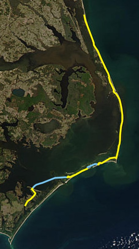
Beginning at its northern terminus in Corolla, North Carolina (near the Currituck Beach Lighthouse), NC 12 (affectionately known as the "Beach Road") travels south along the Bodie Island shoreline through the cities of Duck, Southern Shores, Kitty Hawk, Kill Devil Hills and Nags Head before entering the Cape Hatteras National Seashore. Before crossing over Oregon Inlet to Pea Island, NC 12 passes by Bodie Island Lighthouse. Continuing south, the highway crosses onto Hatteras Island, site of the famous Cape Hatteras Lighthouse. In the town of Hatteras, North Carolina, vehicles following NC 12 board a free ferry to Ocracoke Island, home of the Ocracoke Lighthouse. In the community of Ocracoke, NC 12 follows a toll ferry to Cedar Island where the route continues 12 miles to Sealevel and ends at U.S. Highway 70.
 North Carolina Highway 12 is routed along the Outer Banks. Yellow indicates roadbed while blue indicates the ferry routes.
Attractions along the way
- Currituck Beach Lighthouse at Corolla
- Wright Brothers Memorial at Kill Devil Hills
- Jockey's Ridge at Nags Head
- Bodie Island Lighthouse within the Cape Hatteras National Seashore
- Cape Hatteras Lighthouse near Buxton
- Ocracoke Lighthouse near the village of Ocracoke
- Portsmouth on Portsmouth Island (view only from ferry)
Hurricane Isabel
Hatteras Island was cut in two on September 18, 2003 by Hurricane Isabel which opened a new inlet 3,000 feet (910 m) wide and 30 feet (9.1 m) deep through the community of Hatteras Village on the southern end of Hatteras Island. This new inlet was temporarily named the Isabel Inlet after the hurricane. Road access along NC 12 was temporarily severed until the island was repaired and restored by sand pumped ashore by the Army Corps of Engineers.[citation needed]
Hurricane Irene
NC 12 was severed in two places by Hurricane Irene in late August 2011. The road was breached by two small inlets, about 200 feet (61 m) across apiece, in the Pea Island National Wildlife Refuge, and north of Rodanthe. As a result, the only way to access Hatteras Island was by ferry. On October 10, 2011, a temporary bridge opened over the largest breach. The bridge, which is 662 feet (202 m) long, could be in place for more than 10 years while other solutions are thought out.[1]
History
- 1920s: NC 12 is born as a route from Pollocksville, North Carolina (near New Bern) to the Virginia border, through Kinston, Rich Square, Tarboro, and Murfreesboro.
- 1934: NC 12 north of Kinston was truncated and US 258 took its place.
- 1950s: NC 58 completely took over NC 12's remaining route and NC 12 was decommissioned.
- 1962: A road linking the southern and central Outer Banks communities is paved and designated as NC 12.
- 1963: A bridge across Oregon Inlet is constructed and NC 12 is routed along it. This bridge was built to eliminate the need for ferry service to and from Hatteras Island and to provide a quick hurricane evacuation route.
- 1987: NC 12 is extended north of Nags Head along the Virginia Dare Trail (then Business US 158).
- 1988: NC 12 is extended further to Corolla, its present northern terminus.
- 2003: Hurricane Isabel created the Isabel Inlet, severing NC 12's link to the lower Hatteras Island communities. This segment of shoreline was later filled and the missing NC 12 roadway was rebuilt, this time farther from the shore. This is NC 12's current alignment.
- 2007: Subtropical Storm Andrea caused high winds to push waves over dunes and onto the highway on Hatteras Island, leaving water a foot deep and sand 2 to 3 feet (0.91 m) deep in some places.[2]
- 2011: Hurricane Irene washed out more than one section of the highway.[3]
Junction List
County Location Mile Destinations Notes Currituck Corolla North Beach Access Ramp NC 12 ends Dare Whalebone US 64 west / US 158 west – Manteo, Kill Devil HillsCarteret Sealevel US 70NC 12 begins 1.000 mi = 1.609 km; 1.000 km = 0.621 mi
Concurrency terminus • Closed/Former • Incomplete access • UnopenedSee also
- Cedar Island
- Hatteras Island
- Oregon Inlet
- North Carolina Ferry System
References
- ^ Fernandes, Deirdre (October 10, 2011). "N.C. 12 has opened, restoring traffic to Hatteras Island". The Virginian-Pilot (Norfolk, Virginia). http://hamptonroads.com/2011/10/nc-12-reopen-restoring-traffic-hatteras. Retrieved October 11, 2011.
- ^ Season's first named storm unleashes band of rain | HamptonRoads.com | PilotOnline.com
- ^ [1]
External links
The Outer Banks of North Carolina Landforms Places Currituck County · Dare County · Hyde County · Carteret County
Carova Beach · Corolla · Duck · Southern Shores · Kitty Hawk · Kill Devil Hills · Nags Head · Manteo · Wanchese · Rodanthe · Waves · Salvo · Avon · Buxton · Frisco · Hatteras · Ocracoke · PortsmouthWaterways Lighthouses Protected areas Transportation North Carolina Highway 12 · U.S. Highway 64 · U.S. Route 158 · Virginia Dare Memorial Bridge · Dare County Regional Airport · First Flight Airport · Billy Mitchell Airport · North Carolina Ferry SystemHistory Categories:- State highways in North Carolina
- Transportation in Currituck County, North Carolina
- Transportation in Dare County, North Carolina
- Transportation in Hyde County, North Carolina
- Transportation in Carteret County, North Carolina
- Outer Banks

Wikimedia Foundation. 2010.