- North Carolina Highway 7
-
NC 7
Route information Maintained by NCDOT Length: 12 mi (19 km) Existed: 1932 – present Major junctions West end:  US 321 (Chester/York Streets) in Gastonia, NC
 I-85 in Gastonia
I-85 in Lowell/McAdenville
I-85 in western Belmont

 US 29/74 in western Belmont
East end: US 29/74 in eastern Belmont, NCLocation Counties: Gaston Highway system ←  NC 6
NC 6NC 8  →
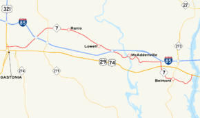
→NC 7 is a twelve-mile (19 km) North Carolina state highway. It is possibly the most confusing in the state to follow. During its stretch, entirely in Gaston County, NC 7 switches roads and merges many times. Its main purpose is to connect eastern Gaston County municipalities with the county seat of Gastonia.
Contents
Route description
Gastonia, Ranlo, and Lowell
NC 7's western terminus is at US 321, just north of downtown Gastonia. US 321 at this point is divided onto two roads: North Chester Street and North York Street. NC 7 is also known as Ozark Avenue in the city of Gastonia. Traveling in a northeasterly direction, NC 7 crosses I-85 for the first time and shortly after, intersects with NC 279. After crossing Spencer Mountain Road into the town of Ranlo, NC 7 becomes the aptly named Lowell Road since the next town NC 7 enters is Lowell. Once inside the Lowell town limits, NC 7 is also known as West First Street. In downtown Lowell, NC 7 turns left onto Main Street and quickly turns right onto Third Street, where NC 7 makes its second crossing of I-85 (exit 23).
McAdenville and ChristmasTown USA
Immediately after crossing I-85, NC 7 enters one of North Carolina's most famous cities: McAdenville. Every Christmas season, McAdenville residents deck nearly every square foot of the town with decorations; the event is known as ChristmasTown USA. During this time, NC 7 can become a traffic nightmare as tourists flock to McAdenville. Through this segment, NC 7 is known as Main Street. Immediately after crossing the South Fork Catawba River and leaving downtown McAdenville, NC 7 makes another turn, onto Riverside Drive, which is renamed McAdenville Road a half-mile down the road.
Cramerton and Belmont
After skirting the outskirts of Cramerton, NC 7 once again changes road. This time NC 7 moves right onto Old NC 273 in Belmont; exit ramps to another interchange with I-85 (exit 26) are found near this intersection. Oddly, NC 7 crosses US 29/74 and then loops around downtown Belmont, before going back to US 29/74, where it ends. Through town, NC 7 is known as Main Street, and then as Catawba Street. NC 7 and NC 273 do intersect in the center of downtown Belmont. Three quarters of a mile after this intersection, NC 7 comes to its eastern terminus.
History
- 1932 - NC 7 is born on its current alignment through Gaston County.
- 1934 - For a short time, NC 7 is longer. It runs further west of Gastonia, to Kings Mountain, North Carolina on today's US 29/74 and US 74 Business.
- 1939 - US 29/74 is rerouted to make a straight run from Kings Mountain to Gastonia, and NC 7's length is moved back to what it was in 1932.
External links
Categories:- State highways in North Carolina


Wikimedia Foundation. 2010.